Volcanic Cave Areas in Victoria
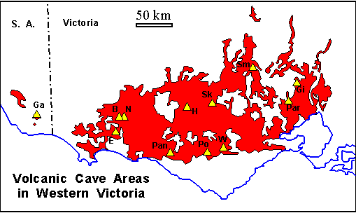
The extent of the Newer Volcanics Province is shown in red. Volcanic cave areas are shown in Yellow triangles and Labeled as follows:
This site also has pages describing the way volcanic caves are formed and decorations and features found within volcanic caves.
B: Byaduk E: Mt. Eccles Ga: Mt. Gambier Gi: Gisborne H: Mt. Hamilton N: Mt. Napier Par: Parwan Pan: Panmure Po: Porndon Sk: Skipton Sm: Smeaton W: Warrion Hill NOTE: Most of the caves require a permit from the manager (e.g. The local ranger at Mt. Eccles) before they can be entered. No permit is needed for Tunnel Cave and Natural Bridge at Mount Eccles or for Harman Cave at Byaduk.
Mount Napier is one of the younger volcanoes in the area, probably erupting about 8,000 years ago. A few small caves occur in the scoria of the summit crater, and several small lava tubes and an arch are known on the slopes of the mountain. A scoria cone there may be a rootless vent fed from a lava tube. It feeds a short channel with several roofed segments. There are also some interesting subsidiary explosive craters on the sides of this mountain. A long lava flow runs down the Harman Valley to the west of Mount Napier, and contains the extensive Byaduk Caves (see below).The Byaduk Caves are near the start of a long, tunnel-fed lava flow that runs down the Harman Valley to the west of Mount Napier. Collapse of parts of the main feeder tunnel has exposed the largest and most spectacular tunnels, arches and collapse dolines in the region. The largest tunnels are up to 18 m wide, 10 m high and extend to depths of 20m below the surface. There are also some smaller but more complicated caves, and a multilevel system which has a shallow surface maze, and two lower levels connected by lava cascades and chutes where the lava drained downward to the lowest level.

Collapse doline of Bridge Cave, Byaduk. A second collapse hole is behind the person on the surface. The Tumuli: Further down the Harman Valley the surface of the flow has excellent examples of surface pressure ridges and clusters of 'tumuli': rounded steep-sided domes of lava up to 10m high and 20m across that formed when the lava crust was pushed up by pressure from below.
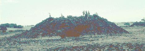
A Tumulus in the Harman Valley
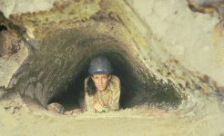
At Mount Eccles the main volcano erupted between 20 and 30 thousand years ago. It has a deep steep-walled elongate crater which contains Lake Surprise. The crater wall has been breached at its north-western end by a large lava channel (or "canal" as they are called locally) that flows west and then branches into two main channels running to the west and to the south. A line of smaller spatter and cinder cones and craters extends to the southeast from the main crater. Another small but well-defined lava canal runs southwards from one of these and ends at the Natural Bridge, which is a roofed over section of the canal. The pointed, 'gothic' roof of this cave (see photos) suggests that it was roofed by levee overgrowth (a process described elsewhere) - and the contorted layers visible in its walls (second photo) would be linings that were built up and then slumped while still hot. Tunnel Cave is found where the lava canal leaves the main crater. This is an easily accessible cave, right next to the walking track.

Entrance to Natural Bridge Cave,
Note "gothic" roof shape.Beyond this central area, basalt lava flows form a field about 16 km long and 8 km across. From the western end of this lava field a long flow, the Tyrendarra Flow, runs 30 km southwards to the present coast and continues offshore for a further 15 km - indicating that it formed at a time of lower sea level. This must also have had a major feeder tube, but no drained sections have been discovered to date.
Most of the longer caves at Mount Eccles are in or adjacent to the lava canals, but there are a number of small caves scattered throughout the area, and the known distribution may simply reflect the more intensive exploration along the main canals. The 'stony rises' on the surfaces of the lava flows do not lend themselves to easy exploration, or navigation! The caves associated with the canals are generally formed in the levee banks on each side and would have fed small lateral lava lobes or sheets when the canal overflowed . Some are simple linear feeder tubes, but many have branching forms and complexes of low broad chambers which suggest draining from beneath the solidified roof of a series of flow lobes. They show a good range of lava 'decorations' .
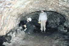
Small lava tube in the South Canal. Larger tube beside South Canal.
Mount Gambier is a set of large scoria cones and craters and a maar lake that formed in a violent steam-driven explosion. It was thought to be fairly young, but recent work has pushed the age back to greater than 28,999 years. Several small weathering caves occur in the ash deposits. There are also a few small lava flows, and small lava caves are reported in the base of these flows. However, this area is better known for its limestone caves and water-filled sinkholes.
The Gisborne Bone Cave was first described and mapped in 1859. It is a small but complex network of small passages at two levels, most of which were originally nearly filled with sediments (and animal bones). It has a small outflow stream, presumably fed by seepage from the hill above. The cave is in weathered tuff beneath basalt, and is not a primary lava cave. Its origin is uncertain - Gill (1964) suggested that it may have been 'dug out by fossorial animals'! From the descriptions, this might be a 'piping cave' formed by the seepage water carrying away the fine clay minerals to leave small tunnels. If so, it is quite a different type of pseudokarst and unrelated to the volcanism.
Near Mount Hamilton there is one large, complex, multilevel, lava cave with a difficult entrance, and several smaller caves. The large cave has about 1200 m of passages reaching to depths of 15m below the surface, and is the longest and most complex system in the province. It is a set of branching and anastomosing tubes up to 5m high and 6m wide with smaller constrictions at intervals. An early explanation of the complex form was by to the breaching and draining of a single thick flow that was partly solidified. An alternative explanation might be a multi-level variation of the drained lobe process.
Parwan has a single 240 m tunnel with several broad low arched chambers, considerably modified by collapse. The floor is of red soil, and several interesting minerals have recently been collected, including one, 'Parwanite', which appears to be a new type. This may be one of the oldest caves in the region as similar basalt lava flows 25km to the east have been dated at 2.5-2.7 Million years.
At Panmure a single bifurcating lava tube has been intersected by a quarry. This one still has many bats - possibly because it is seldom visited. This appears to be in a flow 540,000 years old.
Mount Porndon has some interesting surface volcanic features and two lava tubes. Porndon Arch Cave is a simple 100 m long tunnel with a typical arched cross-section up to 15m wide and 9 m high. It has a well developed lava bench. The Rubbish Cave appears to be more interesting as the floor and roof have a similar curvature and the floor rises to join and match the roof at the end of the cave, suggesting that either there is a tube-in-tube or that the present floor might be a roof lining that has sagged down to the floor! This cave was reported to originally have been longer but the entrance section collapsed at some time in the 1930s.
The single cave at Mount Widderin consists of two connected broad chambers and several smaller chambers at the end, all much modified by collapse. The cave had a large bat colony in the last century but these had already left by 1895. The guano deposits contained an interesting insect population and a number of unusual mineral deposits - it is the type area for several phosphate minerals as well as for an insect species. Unfortunately it has suffered from heavy visitation, so both insects and minerals have probably now been trampled into oblivion.
Near Smeaton, Mount Kooroocheang is a large composite ash cone which contains two hornitos. Armchair Pot is a single small shaft about 9m deep with walls coated by melted rock. A low rock wall, the 'armchair', partly surrounds the entrance. The shaft probably developed by the escape of gas and molten material through a break in the crust of a lava flow and the 'armchair' was probably built up from semi- solidified spatter blown out of the shaft. The second hornito is nearly filled with a convex basalt plug.
At Warrion Hill five small lava caves have been recorded in 'stony rises' country. The longest is about 50m of low wide tunnel.
Last modified on 2 June 1999
HTML: Copyright © 1998,1999, K.G. Grimes
Email: ken-grimes@h140.aone.net.au
May be reproduced for non-commercial use provided this
copyright notice is retained in full.
URL for this page:http://www.netserv.net.au/cwork/ackma99/grimes/VCAreas.html