Natural Bridge, Mount Eccles
Note that although you can explore much of the cave by natural light from the entrances, you should bring torches (with decent batteries!) if you want to go right through as it gets a bit gloomy in the middle and it is easy to slip on the damp rock. A bright floodlight will show the full range of colours, which is not normally visible
 Natural
Bridge is a "lava tube" formed by the roofing of a lava channel.
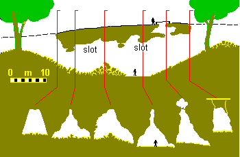
The diagram shows a long section and cross-sections. The sections
show the angular "gothic" roof shape which indicates that this roof developed
by the inward growth of levee banks on each side. This process is
described in another page. As well
as growing out and over the channel to form a roof the layered banks slumped
downward while still semi-liquid. We can see the resulting contorted
layers exposed within the cave where parts of the lining have broken
away.
Natural
Bridge is a "lava tube" formed by the roofing of a lava channel.
The diagram shows a long section and cross-sections. The sections
show the angular "gothic" roof shape which indicates that this roof developed
by the inward growth of levee banks on each side. This process is
described in another page. As well
as growing out and over the channel to form a roof the layered banks slumped
downward while still semi-liquid. We can see the resulting contorted
layers exposed within the cave where parts of the lining have broken
away.
 |
 |
| Entrance to Natural Bridge Cave,
Note "gothic" roof shape. |
Contorted roof inside the cave indicates slumping of the levee layers. |
The small hole on the surface connects to the main cave below. Do not climb into this. The guard rail is there for a good reason - the apparent floor of the small upper chamber often has a cover of loose leaves which can hide a dangerous hole and 10m fall into the main cave below!
There is an interesting walk from the car park, back up the lava channel to its source in a small crater, and you can continue from there right back to the main crater and lake at Mount Eccles.
Last modified on 2 Sept 1998
HTML: Copyright © 1998 K.G. Grimes
Email: ken-grimes@h140.aone.net.au
May be reproduced for non-commercial use provided this
copyright notice is retained in full.
URL for this page:http://www.netserv.net.au/cwork/ackma99/grimes/VC3H10.htm