Introduction
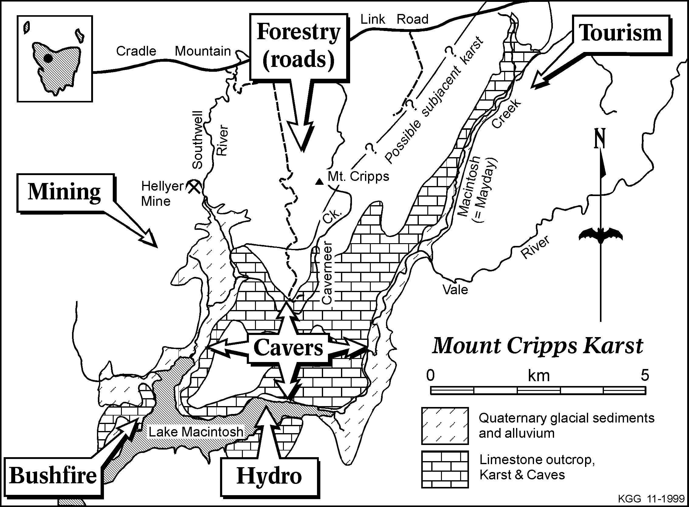
The Mount Cripps karst lies 80 km south of Burnie in the north west of Tasmania. The well-known tourist destination of Cradle Mountain lies approximately 20km to the southeast. The karst area is bounded to the north by Mount Cripps and to the south by Lake Mackintosh, an impoundment formed when the Hydro Electric Commission flooded the Mackintosh and Sophia river valleys. To the east is the Vale River and Mount Remus, and to the west is the Southwell River and Mount Charter. The Mount Cripps area has been documented using the prefix "CP", but was formerly known as "MY" as currently listed in the 1985 ASF Karst Index book under "Mount Mayday". Much of the information used in this article has been recorded in 'Speleopod', the journal of the Savage River Caving Club.
For many years the remoteness of the Mount Cripps karst area caused it to remain unvisited and unknown. Whilst a track of sorts existed along the Vale River, the heavily wooded hills and gullies to the sides had until recent years only been viewed from the air. Attempted exploration of the Mount Cripps karst was carried out by members of the Southern Caving Society in the late 1960s and early 1970s. The karst was only accessible from the north by a private logging road near Mayday Creek and from Tullah to the south via old mining tracks in the Sophia valley. As Lake Mackintosh formed, Southern Caving Society members included boat trips along the banks of the rising impoundment. Hydro Electric Commission personnel who had located the limestone alerted them. Campsite Conduit (CP 48) and The Gallery (CP 53) were discovered on one of these boating trips. The karst has been systematically explored since 1988 by The Savage River Caving Club and has yielded over 200 caves of various types (Gray & Heap, 1996).
The lack of drainage concentration from neighbouring impermeable rocks has prevented large stream caves being formed such as are common in other major karst areas in Tasmania. Therefore streamsinks that engulf permanent creeks are rare, but examples include Stettle Pot (CP 42), The Water Race (CP 19) and Epicin Cave (CP 145). Most of these streamsinks contain intermittent creeks, which can be quite spectacular in wet conditions, e.g. Top Cliff Sink (F 50).
Apart from numerous solution dolines there are also collapsed dolines e.g. Quasitomo Cave (CP 30). Blind valleys ending abruptly at cave entrances are also evident. Double Creek Sink (CP 81 and CP 88) is at the convergence of two valleys forming one underground drainage system. Cliff lines are a common surface feature with some extending into the dolines e.g. The Colosseum (F 19). Well-developed rundkarren is apparent in many areas of little soil cover; most of which is covered by moss or lichen. The karst is characterised by large-scale closed depressions and a high density of caves with limited surface drainage.
The hydrology of the Mount Cripps Karst has been difficult to determine due to the lack of permanent streamsinks and the probability of major resurgences lying beneath Lake Mackintosh. The Savage River Caving Club has carried out one major study, but the results were inconclusive apart from the Double Creek Sink system (CP 81 and CP 88) being linked to Ultimate Outflow (CP l60) along the Vale River.
Of particular note are the evolution of this karst in an area that was subject to multiple Pleistocene glaciations and the presence of well-developed polygonal karst. This type of karst is completely pitted by crowded closed depressions, dolines or sinkholes so that narrow ridge-like divides between them form a crudely polygonal shaped network. The area is one of few south-eastern Australian Palaeozoic limestone karsts with its original forest cover still intact.
Human impacts
The following information aims to highlight some of the human impacts, which have occurred in and around this area of "pristine" karst over the past twenty years. Human impact on the Mount Cripps karst in recent times has come from several definite areas:
- FORESTRY OPERATIONS (Roads and associated quarries, plant invasion, improved human access).
- MINING OPERATIONS (Stream sediments, quarries for gravel and limestone, continuing exploration).
- HYDRO-ELECTRIC COMMISSION (Flooding and changes to karst hydrology, improved access, exotic fish).
- BUSHFIRE (Vegetation and soil damage).
- TOURISM (Visitation causes 'wear and tear').
- CAVERS (Track access and erosion, 'wear and tear').
1. Forestry operations
The karst is vegetated by Tasmanian rainforest, which is a cool temperature, myrtle dominant rainforest. Large eucalypts pierce the canopy with mixed amounts of other rainforest species beneath. These include Sassafras, Leatherwood, Blackwood and Celery Top Pine, which are all commercially prized for specialised timber products and craft wood.
The gradual push southwards by APPM Forests, Burnie to extend their exploratory roading programme and subsequent logging operations led to an assessment party exploring the karst in December 1986. The access road followed the western slopes of Mount Cripps and along an obvious ridge leading to the karst area. The road was cut through steep country and had to negotiate several steep gullies. Gravel for the road was easily obtainable nearby with several pits and small quarries still visible adjacent to the road. When limestone was found all operations were immediately stopped pending a survey to establish the likely extent and nature of cave and karst development in the area (Gray & Heap, 1996). A boom gate was erected to restrict access and this is still in use today, despite several attempts by unruly elements to destroy it in order to reach an abundance of firewood and myrtle craftwood. Numerous padlocks have been broken and the gate has been cut with a power saw. The gate has proven to be an effective control in caving activities where the Savage River Caving Club has taken on the role of guides for state, interstate and international cavers. The roading programme avoided construction on the limestone but one of the gravel pits and road run off are within a karst catchment. Water running from this area flows into the Quasitomo Cave system (CP 30). The local gravel supply was seen as an economical, local source for the Hellyer Mine. No quarry operation has begun up to date. Although the roads avoided the karst directly, problems can still arise from subjacent karst collapse beneath a different surface rock type.
With the roading came a variety of plants colonising the disturbed areas. Apart from the local rainforest plants in the area reseeding in the road gravel, several opportunistic species have colonised the roadsides. These include Acacia mucronata, Prostanthera lasianthos, Coprosma hirtella, Oxylobium ellipticum and Epacris impressa. Similarly exotic plants have also been introduced, the most visible being the bright yellow gorse, which once seeded, is very difficult to eradicate.
Prior to 1991 the Mount Cripps karst was managed by APPM Forests, Burnie (now North Forest Products), as part of its 1926 forest concession. Once the exploratory programme ceased, permission was given to Savage River Caving Club to explore the area and to prepare reports for the company on the karst development to assist in determining the most appropriate management for the area.
This was to be the beginning of another human impact to the region, cave exploration! (See later). The Savage River Caving Club has had a good working relationship with North Forest Products and Forestry Tasmania throughout the exploration phase at Mount Cripps (Warner, 1995). When the club produced a book called "Beyond The Light" (Gray & Heap, 1996), which described in detail the caves, and karst of Mount Cripps, North Forest Products gave financial assistance for its publication.
Prior to the Regional Forest Agreement (RFA) the Mount Cripps area became a deferred forest, classified as a RAP, Recommended Area for Protection, but subsequent to the RFA, the RPDC, Resource Planning and Development Commission have changed the status of many RAP's, including Mount Cripps, to potential reserves that permit exploration and/or mining. (Clarke, 1998).
2. Mining operations
The world-class Hellyer underground mine was opened in 1989 on a blind ore body discovered in 1983. The mine is located to the south of the Cradle Mountain link road, on the western side of the Southwell Valley, on the northern end of the Cambrian Mt. Read Volcanic Belt. The mined ore is rich in zinc, lead and copper with small amounts of silver and gold. The ore is concentrated on site, with the concentrates railed to Burnie for shipment. The main porthole for the mine itself lies approximately 1 kilometre to the north west of the karst boundary within the Southwell River valley. The ore is trucked away from the valley to the processing mill and associated tailings area. However, fine sediment clouding the length of the Southwell River from the mine to Lake Mackintosh has been observed by the author. Runoff from the mine access road may have been the cause.
Other pressures put on the Mount Cripps karst due to nearby mining operations have included plans to quarry for gravel and recently for limestone to be used in the treatment of tailings. The effect of limestone quarrying would have an obvious direct impact on the karst generally; it would destroy cave and karst features, release sediment into stream caves threatening aquatic cave fauna and there would also be the threat of pollution from spillages. A karst expert is currently undertaking an assessment into the environmental aspects of a limestone quarry at several proposed sites on the karst with input from Savage River Caving Club members.
With the signing of the Regional Forest Agreement in November 1997, deferred forest status was extended to the region pending the area becoming a reserve in the near future. However the mining industry were given certainty of access allowing exploration and mining to occur in reserved areas.
3. Hydro-Electric Commission
The building of a dam in 1981 by the Hydro-Electric Commission, which created Lake Mackintosh, was the first major step in providing easy access to the area. Unfortunately it has been via the lake that the maximum damage has been done. The impoundment flooded the button-grass plains in the Sophia Valley and the heavily wooded areas along the Vale River and Southwell River Valleys. Large numbers of myrtle trees were drowned up to the maximum supply level of the lake. This level fluctuates leaving some dead trees "high and dry" around the perimeter of the lake. The vast number of dead trees killed by the lake formed a corridor which allowed fire to decimate the vegetation around the lakes shores in early 1995 (see later).
The inundation of the Mackintosh and Sophia river valleys flooded numerous outflow caves, which were known to local bushwalkers (Gray & Heap, 1996). Adjacent karst areas have also been submerged beneath the lake e.g. White Hawk Creek, as have several cave sites of Aboriginal occupation. A major excavation carried out by La Trobe University in 1990-91 gave a clear picture of occupied sites in this area extending back to the end of the previous ice age 10,000 + years ago (Stern & Marshall, 1993).
One cave system noted for its masses of speleothems is located within a few metres of the lake and is easily accessed. This may cause problems in the future where the unwitting public may visit such a cave from the comfort of their boat. Some damage has already occurred in this cave.
Lake Mackintosh is used for recreational use such as boating and fishing. The lake has been stocked with rainbow trout with one large specimen being seen swimming upstream in Caverneers Creek some 4 kilometres from the Southwell Inlet.
4. Bushfire
Several major bushfires began in the area in late 1994 and early 1995 following unusually dry summer months. A devastating fire, which was to affect the Mount Cripps karst, started in early January 1995. An electrical storm was officially "assumed" to be the cause but there is anecdotal evidence that a campfire left by fishermen may have been the true cause. (R. Boyle pers comm.) The fire quickly jumped from one side of the lake to the other via the dead myrtle stags in the lake. The fire thus spread into the karst region on the northern side of Lake Mackintosh, damaging approximately 20-30% of it. The soils overlying the limestone are shallow and damage by fire can cause alteration of the acid balance due to depletion of humus. Similarly landslips and soil movement may occur on the steeper slopes. This has occurred in the vicinity of The Sanctuary (CP 50) where the vegetation was destroyed allowing soil and many limestone shards to accumulate on the lower slopes. The fire has also affected caves with active stream ways. Sediment influx and charcoal debris has been washed into some of the active systems. Charcoal flecks and burnt plant matter were found in the entrance stream way of Dimple Cave (CP 27) approximately fifteen months after the Mount Cripps fire. (A. Clarke pers comm. 1996). A further inspection six months later revealed a substantial accumulation of charcoal debris and burnt myrtle leaves. Previously collected aquatic amphipods present on the first visit were completely absent on the last inspection in the same stream way section of Dimple Cave.
Members of the Savage River Caving Club have undertaken experimental monitoring of re-growth on several karst sites affected by the bushfire. After four years the trend is in favour of rainforest species regenerating the area, after initial eucalypt seedlings were decimated by wildlife.
5. Tourism
In 1993 a proposed 154-bed tourist development at Lake Lea in the Vale of Belvoir, 14km NE of Mount Cripps, posed a serious threat to water quality in the Vale River, which rises in that area. Further downstream the river flows along the eastern boundary of the karst into Lake Mackintosh. The Vale of Belvoir is a high altitude, sub-alpine grassland and is also a karst area. Treated effluent was to have been piped for several kilometres and then pumped into the river. Apart from the problem of water pollution along the course of the Vale River, the Department of Environment and Planning failed to take into account the karst hydrology of the region. Strong lobbying by several groups including Savage River Caving Club, North West Walking Club and the Tasmanian Conservation Trust put pressure on local and state government officials by highlighting the problems of the proposal. The development did not progress beyond the planning stage. There are still proposals for tourism projects in this area and other demands include recreational fishermen, four-wheel driving and campers.
The nearby Cradle Mountain Lodge has conducted four-wheel drive tours to Mount Cripps advertised as half-day trips to its patrons. Although primarily interested in the rainforest rather than the karst, the increased traffic has put pressure on the area. Deteriorating road conditions, litter and toilet stops have all been problems encountered.
6. Cavers
It seems ironic that a group of dedicated people with a common interest in cave exploration would pose a threat to the surface karst and the caves beneath. The need for detailed exploration of Mount Cripps has been essential over the past twelve years to guarantee some form of protection afforded by the Public Land Use Commission as part of the Regional Forest Agreement. However non-deliberate damage has occurred to the surface karst via the tracks cut into the area and cumulative damage is evident within the caves themselves.
The Savage River Caving Club has been aided in their exploration of the karst by the erection of a small, unobtrusive overnight accommodation site, "Th'ut", located in rainforest near the northern boundary of the karst. This has reduced the need to erect campsites in the area, thus minimising local impact.
The soils overlying the limestone are shallow and fragile which means the passage of small groups of people along set tracks quickly causes damage that might take many years to recover. In 1992 the SRCC realised the need for some form of control to protect this delicate environment. This included controlling maximum party sizes and the maintenance of only three main access tracks into the karst. All minor tracks would have flagging tape removed when exploration was concluded in that area. Continued use of the boom gate was encouraged to limit access to the karst. Even with these safeguards in place there has been trampling of vegetation and track erosion. Steep sections of track have been most vulnerable to excessive wear, as on the Philrod Track near Caverneers Creek. This steep section of track became so eroded that it was closed indefinitely with a new track contouring around the slope. Thick scrub has also been regularly cut through to keep these main tracks accessible. This has safeguarded random "bush bashing" to get to different regions of karst, thus minimising the amount of surface damage.
The caves too are equally sensitive (Kiernan, 1989). The caves of the Mount Cripps area lack the ability to erase muddy footprints, with the likelihood that marks left today will still exist for many years into the future. The most heavily visited caves are also those needing the most protection: Philrod Cave (CP 37), Snowy Mountain Cave (CP 11) and The Sanctuary (CP 50). In Philrod Cave (CP 37) a delicate floor of soft sediment encrusted with moonmilk has been totally destroyed by excessive foot traffic, with gullying occurring in the mud. Many of the smaller caves contain calcified bones, shells and delicate floors, which can be destroyed with one careless footstep. Fragile clastic deposits have been damaged in Snowy Mountain Cave (CP 11) along the entrance stream way. Once again gullying has occurred at the head of a short pitch where the ladder sits on soft humus deposits. Accidental damage to speleothems is evident in several caves, including The Sanctuary (CP 50), where numbers of straw stalactites have been broken by careless passage through the cave. Several cave entrances have been dug open to allow exploration e.g. Roaring Forties One (CP 89), altering the air exchange between the caves and the surface. This may have a long-term effect on such caves where destruction or desiccation of speleothems can occur due to an unnatural change in cave air meteorology. Similarly, cave fauna can be vulnerable to even a slight modification in cave environment.
Conclusion
Despite this catalogue of human impact and damage in and around the Mount Cripps karst, it remains an area of outstanding beauty with unique values, whose protection has been proposed by both government and public groups alike. The Savage River Caving Club will continue to strive for a reserve status to cover the Mount Cripps karst, which should be managed primarily for the preservation of its unique features that contribute to biological and geological diversity, and should not promote public visitation to such a fragile landscape.
Acknowledgements
I would like to thank the Editor/Librarian of the SRCC, Lyndsey Gray, for keeping accurate records of club activities at Mount Cripps, without which articles such as this could not be written. I would like to thank Ken Grimes for editing the final draft. I would also like to thank Arthur Clarke for his encouragement and advice in the compilation of this paper.
References
Clarke, A. (1997). Management prescriptions for Tasmania's Cave Fauna. Report to the Tasmanian Regional Forest Agreement and Heritage Technical Committee.
Clarke, A. (1998). The Tasmanian Regional Forest Agreement (RFA); "Non-outcomes" for Cave and Karst Conservation in Tasmania. ACKMA Journal No.33. pp.28-31.
Gray, L. and Heap, D. (eds.) (1996). Beyond The Light: The Caves and Karst of Mount Cripps. Savage River Caving Club Inc. Burnie, Tasmania.
Kiernan, K. (1989). Issues in Cave and Karst Management. Australian Parks and Recreation, 25 (4): pp 28 - 32.
Stern, N. & Marshall, B.(1993). Excavations at Mackintosh 90/1 in western Tasmania: a discussion of stratigraphy, chronology and site formation. Archaeol. Oceania, 28: pp 8 - 17.
Warner, A., 1995: Mt Cripps Karst Management - Land management, Thoughts and Actions. 'Proceedings of the 11th Australasian Conference on Cave and Karst Management. Tasmania, 1995. pp 97 - 102.