Abstract
A Cave Impact Assessment Rating System (CIARS) was developed to quantify the physical impacts of recreational caving on a range of cave environments. The CIARS method also sets a base upon which repeats of assessment allow the rate and degree of change in the physical state of the cave to be quantified. The CIARS method utilises a set of criteria to enable visual assessment of floor, wall, and ceiling impacts in areas of a cave. It is an attempt to render visual descriptions of physical cave impacts quantifiable and replicable by different operators. The CIARS method was trialled and developed in several caves and eventually applied to the Zweihohlen and Henry Lambert Sections of Gardner's Gut Cave, Waitomo, New Zealand (an open access cave heavily used by recreational cavers). Results indicate that the more severely impacted areas of a cave are those with trails located on clastic floor materials, areas with unmarked or non-defined trails and those where trails are located close to walls or are in confined sections of passage. The lowest impact ratings were in those sections where trails were located on rockfall deposits in relatively undecorated areas of the cave. The impacts of recreational caving were rated as severe in the Zweihohlen and Henry Lambert Sections of Gardner's Gut Cave reflecting the level and intensity of use of the cave.
1.0 Introduction
The aesthetic and scientific values of wild caves (caves not modified for tourist development) are being degraded as a result of recreational use (Spate and Hamilton-Smith, 1991). Cave managers and cavers accept that all recreational use of wild caves will have an impact on the resource and, in most cases, the impacts are irreversible (Aley, 1976). This is because natural rehabilitation processes in caves operate slowly in the low energy cave environment. It is, therefore, important to attempt to quantify the extent and severity of impacts in order to establish appropriate management regimes for wild caves and to determine the acceptable limits of environmental change (Wilde and Williams, 1988). The primary reasons for assessing and monitoring recreational impacts on the cave environment are to; provide cave managers with a baseline condition of the cave resource, quantify the degree and rate of change, and assist with identification of the cause of any changes.
Recreational caving results in a variety of impacts on the physical cave environment (Gillieson, 1996; Bunting, 1998). In the first instance there is direct contact between the caver and the floor, walls, and ceiling of the cave. Cavers moving through a cave cause direct impacts to the physical cave environment such as disturbances to cave sediments and cave breakdown deposits, erosion of cave rock surfaces, damage caused by bolting and rigging, modification of cave entrances and passages, speleothem breakage and disturbances to fossil deposits. In addition there are impacts associated with sediment transfer to previously clean areas of cave, carbide dumping, carbide staining on cave walls and ceilings, and the introduction of energy sources from mud and food residues, faeces and urine.
Documented attempts at quantifying recreational impacts in caves have been limited (Seabrook, 1972; Bodenhamer, 1995) and may indicate difficulties in quantifying and subsequently documenting recreational impacts in the cave environment. Cave photomonitoring is another method that may be used to assess and monitor the effects of recreational use on caves. The term "cave photomonitoring" is used to describe precise photographs of selected points within the cave taken on regular basis (Uhl, 1981). The main problem with photomonitoring is the difficulty in accurately and efficiently replicating the system once established (Werker and Werker, 1995; Bunting 1998). In addition photomonitoring involves a high cost of time, equipment and money.
This paper describes the development and application of a visual impact assessment method for wild caves. Criteria are developed that can be used to monitor physical change to the cave environment. The criteria enable impact effects to be evaluated consistently, thus permitting different caves to be compared with one another and also to be compared over time.
2.0 The Cave Impact Assessment Rating System
The Cave Impact Assessment Rating System (CIARS) was developed to visually assess and quantify the impacts of recreational activities that have occurred on the physical cave environment. The method was developed by initially observing and recording physical impacts of recreational caving during visits to various New Zealand caves. A set of impact assessment rating criteria was developed to describe the range and severity of impacts observed. The CIARS criteria are grouped into three distinct divisions; floor, wall, and ceiling.
Areas of the cave are divided into manageable sections, between 2 and 8 meters in length, and floor, wall and ceiling impacts in each of the sections are rated for severity of the impacts following Table 1. For those criteria requiring a percentage assessment, area percentage charts (eg Bates et al., 1982) may be used. The boundaries of each section should be recorded on a cave map so that the assessment may be repeated at a later date to determine the rate, extent and severity of changes. Cave base-maps to be used for impact assessment techniques require a scale of about 1:240 to be of appropriate detail to accurately identify impacts caused by recreational use (Bodenhamer, 1995) although maps at a scale of 1:125 proved to be more appropriate for application of the CIARS method (Bunting, 1998).
A score according to the level of impact (between 0 - 3) is visually assessed for each criteria (Table 1). To determine a total rating for each environment (floor, wall or ceiling) in the section of the cave, the scores for each variable are added and the mean number (impact rating) is determined for that environment. If a variable is not present in a section of cave it is not scored and is not included when calculating the mean impact rating for the particular section. Ratings are determined for the floor, wall and ceiling environments in each section of the cave in order to establish where changes have been occurring when reassessing the same section.
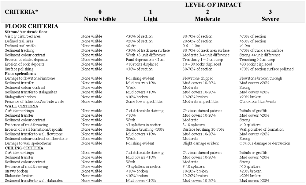
Table 1. Criteria for Cave Impacts Assessment Rating System (CIARS). The criteria are defined and described in Section 3 below.
A final Section Impact Rating is determined for the entire section by calculating the mean of the scores for all the criteria that were assessed in the section of cave. The mean number calculated for each section of cave is used instead of the total sum of the impacts as some criteria are not present in every section of cave assessed, and as such, receive no impact rating. The impacts in each section of cave are then classed as light, moderate, or severe, dependent on the Section Impact Rating for each section (Table 2).
Table 2. Classification of Section Impact Ratings for Each Section of Cave
| Section Impact Rating | Classification of Impact for Section |
| Criteria not Present in Section | |
| 0 | No Impact Visible |
| >0 - 1.38 | Light Impact |
| 1.40 - 1.94 | Moderate Impact |
| 1.94 - 3.00 | Severe Impact |
The Section Impact Rating boundaries for the classification of impact for each section of cave (Table 2) were determined after trialing and applying the CIARS method to sections of different caves with various levels of physical impacts.
3.0 Disturbance Assessment Criteria
Each of the criteria listed in Table 1 are defined and described in more detail below.
3.1 Floor Impacts
a) Impacts to silt/mud/sand/rock floor material
(i) Visibly disturbed area
The amount of visibly disturbed floor area is scored as a percentage of the floor area in the section. Disturbance includes the defined trail areas, and evidence of impacts to the floor off defined trail areas. Boot imprints readily impact soft or very loosely consolidated surface materials. Impacts off the defined trail can eventually lead to the establishment of unplanned trails leading to further impacts on the cave environment. Boot imprints off-trail may also be an indicator of large or poorly managed groups of cavers.(ii) Defined trail area
The amount of defined trail area is scored as a percentage of the floor area in the section. The defined trail is the most obvious trail through the section of cave being assessed. This is influenced by the size of the cave environment in relation to the space occupied by the individual caver going through it.(iii) Defined trail width
The defined trail width is scored as an average of the defined trail width in the section. Common caving practise is for caving parties to move through a cave in single file to limit their impacts on the cave floor so a defined width of less than 0.6 m can easily accommodate cavers moving in single file. Defined trail width is likely to be greater in those areas of caves where cavers must crawl and drag their caving packs alongside. Excessive width of the defined trail area may also reflect large or poorly managed caving parties.(iv) Sediment tracking
Sediments may be tracked into the cave from outside or between different areas of the cave. The score for sediment tracking is determined as a percentage of tracked sediment evident on the defined trail area.(v) Sediment colour contrast
The greater the colour contrast between sediment and the surface it is transferred to, the greater the visual impact. Colour contrast is determined between the colour of materials on the disturbed surface and on the adjacent undisturbed surface using Munsell Soil Colour Charts. A weak colour difference is defined as a less than three-unit difference in hue, value or chroma on the colour chart. A moderate difference is defined as a 3 - 4 unit difference, and a strong difference defined as a unit difference greater than 4.(vi) Erosion of clastic deposits
Erosion of clastic deposits is caused by the activities of cavers moving across the cave floor and may result in the development of depressions or incisions in the cave floor. Multiple incisions may develop in areas of the cave where cavers must crawl and drag their knees across the floor surface. The depth of the depressions or incisions in the cave floor determines the severity of erosion.(vii) Erosion of rock deposits
Visitor movement up and down rockfall slopes and conglomerate banks within caves causes considerable reworking and movement of material downslope. This has an aesthetic impact and may lead to the establishment of unplanned trails. In some cases rocks are intentionally moved to the side of the trail to facilitate access to passages. The score is determined by counting the number of rocks greater than fist size that have obviously been displaced in a section.(viii) Surface polishing
Movement of visitors up and down limestone faces may lead to a polishing effect to the point where it becomes difficult to climb the faces and thus cavers will seek an easier route, thereby expanding the impact. Surface polishing and rounding can also occur in areas where cavers must brush past wall surfaces or where large boulders are used as hand and foot holds. The score for this criteria is determined by estimating the percentage of the bedrock and/or large rocks (those rocks so large that they cannot be easily moved) in a section that are impacted.b) Impacts to floor speleothems
Floor speleothems include areas of flowstone, rimstone, and stalagmites. Stalagmites are defined as those speleothems formed vertically upwards from the floor with a height greater than 5 cm.(i) Damage to flowstone/rimstone
The rating for damage to flowstone or rimstone is determined by observing the level of damage to the flowstone/rimstone area in each section. If the flowstone or rimstone in the area is pristine it is rated as not impacted, evidence of polishing is rated as light impact. Small chips to edges of flowstone or rimstone are rated as moderate impact. If the flowstone or rimstone in the area is broken through to the material beneath, the section is scored as severely impacted.(ii) Sediment tracking
The percentage of the speleothem surface with mud cover is estimated in each section.(iii) Sediment colour contrast
Sediment colour contrast on floor speleothems is determined as defined in Section 3.1a(v).(iv). Sediment transfer to stalagmites
The impact of sediment transfer onto stalagmites is determined by estimating the percentage of stalagmite surface area covered by transferred sediment.(v) Stalagmites broken
The impact of stalagmite breakage is determined by estimating the percentage of stalagmites broken in each sectionc) Presence of Litter
The severity of litter impacts depends on the type of litter/waste. Litter that can be easily removed such as sweet wrappers or clothing threads are classified as low impact while wastes such as food scraps and flagging tape remnants are classed as a moderate impact. Litter such as carbide waste dumps, flash bulbs and human waste are classified as a severe impact.
3.2. Wall Impacts
A cave wall is here defined as the wall area from the floor to a height of 1.6 metres. This was considered to be the limit of where most impacts to cave walls occur. Separate assessments should be made of both the left and right passage walls if possible. To prevent confusion over which is the left wall and the right wall, the direction of travel should be recorded on the cave map.
(i) Carbide markings
The severity of carbide markings is rated whereby just detectable staining is classified as a light impact, obvious stained patches are classed as a moderate impact and initials and/or graffiti are classified as a severe impact.(ii) Sediment transfer
Sediment transfer onto cave walls is caused by cavers hands and/or clothing touching the walls as handholds or for balance. The classification for sediment transfer to cave walls is the same as that described Section 3.1b(i).(iii) Sediment colour contrast
Sediment colour contrast is determined using the Munsell Soil Colour Charts as described in Section 3.1a(v).(iv) Evidence of mud throwing
Mud throwing in caves is deliberate degradation of the cave aesthetic environment. The number of mud splatters, caused by cavers throwing mud on the cave wall in each section, is counted.(v) Erosion of wall formations and deposits
The destruction of cave wall formations and deposits occurs as cavers touch or brush against areas when moving past. Broken coralloid formations littering the floor is evidence that a wall has been impacted. Destruction of wall formations and deposits is determined as a percentage of the wall area impacted in each section.(vi) Sediment transfer to wall flowstone
The classification for sediment transfer onto flowstone walls is the same as that described in Section 3.1b(i).(vii) Sediment colour contrast on wall flowstone
Sediment colour contrast is determined using the Munsell Soil Colour Charts as described in Section 3.1a(v).(viii) Damage to wall speleothems
Damage to wall speleothems is determined by the level of damage to the wall speleothems in the section. The area is either pristine and so classed as not impacted, if some surface polishing is evident the area is scored as a light impact; if some small breakage or chipping is evident the area is scored as a moderate impacted. If major breakage is evident eg broken shawl formations, large areas of wall flowstone damaged, the area is scored as a severe impact.
3.3. Ceiling Impacts
The CIARS assessment for ceiling impacts is only of the ceiling directly above the visibly disturbed floor area. Any ceiling area greater than 3 m above the visibly disturbed floor area is not included in the rating as it is unlikely that ceiling areas higher than 3 m above the floor will be impacted.
(i). Carbide markings
The severity of carbide markings on ceilings is determined in the manner described in Section 3.2(i).(ii) Sediment transfer to ceiling
Sediment transfer onto cave ceilings is caused by cavers hands and/or clothing touching the ceiling. The classification for sediment transfer to the cave ceiling is the same as that described in Section 3.1b(i).(iii) Sediment colour contrast
Sediment colour contrast is determined using the Munsell Soil Colour Charts described in Section 3.1a(v).(iv) Evidence of mud throwing
Evidence of mud throwing is determined by counting the number of mud splatters on the ceiling as described in Section 3.2(iv).(v) Straws broken
Damage to straws is determined by recording the number of broken straws in each section as a percentage of the total number of straws in the section.(vi) Stalactites broken
Stalactites are those speleothems formed vertically downwards from the ceiling/wall with a length greater than two cm. Damage to stalactites is determined by estimating the percentage of broken stalactites in the section.(vii) Sediment transfer to stalactites
The severity of the impact is determined by estimating the percentage of the stalactite surface area that is covered in transferred sediment.
4.0 Application of the CIARS Method
During October and December 1997, the CIARS method was applied to the Zweihohlen and Henry Lambert Sections of Gardner's Gut Cave, Waitomo, New Zealand (Figure 1). This is an open access cave heavily used by recreational cavers.
The (CIARS) methodology was applied to 20 sections of the Zweihohlen and Henry Lambert Sections of Gardner's Gut Cave (Figure 1). The 20 sections were selected to present a variety of floor surface environments and passage characteristics. A summary of the results of the Cave Impact Assessment Rating System for the Zweihohlen and Henry Lambert Sections of Gardner's Gut Cave are given in Table 3. Seven of the sections assessed were rated as lightly impacted, 8 sections were rated as moderately impacted, and 5 sections were rated as severely impacted.
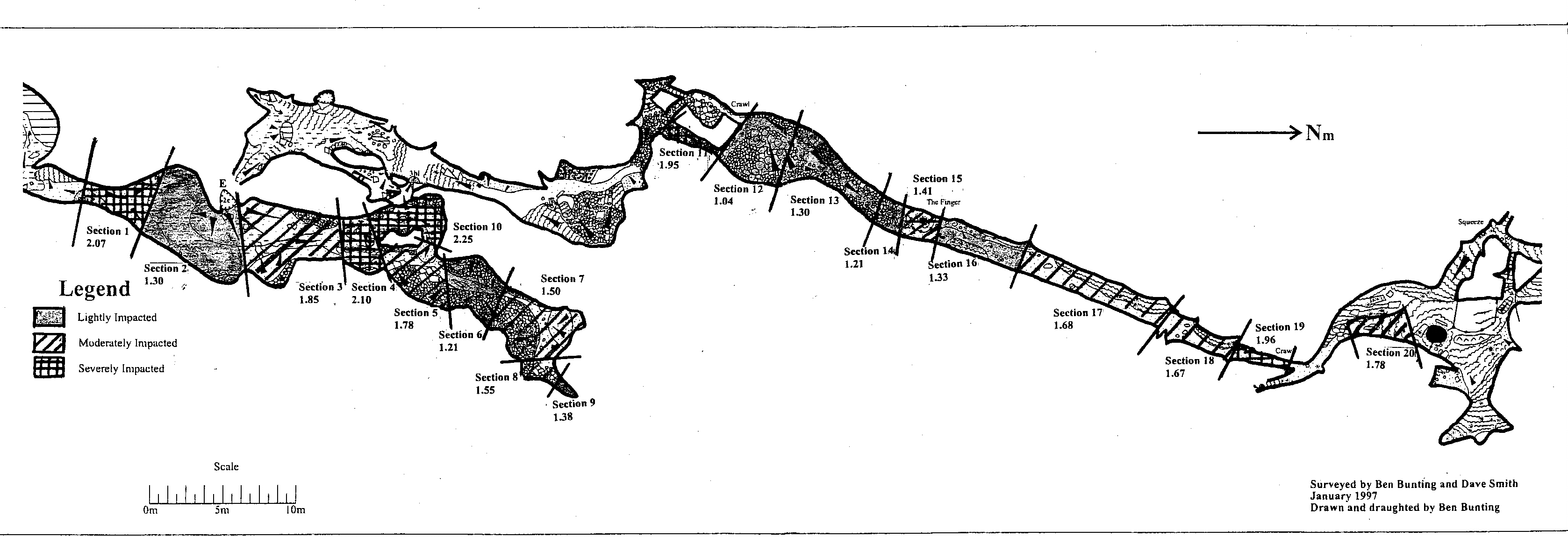
Figure 1. Map of Zweihohlen and Henry Lambert Sections of Gardner's Gut Cave showing areas of cave assessed and CIARS overall mean impact ratings.
The lowest Section Impact Ratings were recorded in those sections (2, 6, 12, and 14, Table 3) of the cave where trails were located on rockfall deposits in relatively undecorated areas, some distance from the cave walls and ceilings.
The greatest impacts of recreational caving were recorded for the cave floor. Impact ratings for sections of cave with predominantly rock floor areas (Sections 6, 7, 8, 12, 13, and 14) were lower than floor areas of softer clastic material (Sections 1, 17, 18 and 19 which indicates that rock floors are far more resistant to impacts than softer floor materials. This result may also indicate that trails are more easily defined on rockfall surfaces as the uneven nature of rockfall deposits limits trail widening. Research on surface trails has shown that trail widening can be limited by rough trail surface conditions (Leung and Marion, 1996).
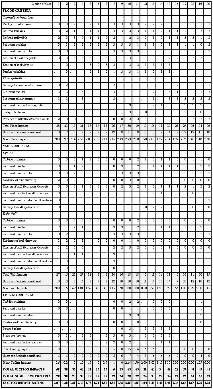
Table 3. CIARS Results for Assessed Sections of Gardner's Gut Cave
Impact ratings for wall impacts were greatest in those areas of passage which are most confined such as sections 10, 11, and 19. Passage restrictions in sections 11 and 19 require cavers to crawl and contact the cave walls and, as a result, wall impact ratings in these sections were high (Figure 1).
Ceiling impact ratings were greatest in sections 4, 7, 10, and 12 due predominantly to breakage of straws and stalactites.
Section 10 received the highest overall impact rating for any section rated in the Zweihohlen and Henry Lambert Sections of Gardner's Gut Cave (Table 3). The reasons for this are the stalactite breakages from the low ceiling, soiling of formations, and polishing of the surfaces of the two holes in the floor where cavers crawl though to the next level of passage. Section 10 is an area where guided groups frequently wait before they descend by rope to the next level of passage.
5.0 Discussion
The results of the CIARS method confirm that impacts to the cave floor are the most common impacts in a cave. Floor impacts are often the most overlooked by cave managers (Spate and Hamilton-Smith, 1991). Many impacts to the cave floor cannot be avoided as cavers have to walk or crawl somewhere as they move through the cave; however proper management practices such as route marking and defining trail boundaries with tape can ensure that impacts are concentrated on trails only (Buecher, 1995).
The cave wall surface includes wall formation (eg. flowstone, coralloid formations), and wall sediment deposits. The impact on wall surfaces is dependent on the size of the passage through which cavers are moving, and the proximity of trails to cave walls. Crawl-ways and narrower sections of the cave are likely to be more severely impacted. Physical impacts to cave walls occur as cavers brush against walls as they travel through the cave, or by transferring sediment from hands and clothing onto clean wall surfaces when using the walls as handholds or for balance. Wall impacts such as mud throwing or graffiti in caves are deliberate degradation of the cave aesthetic environment. Carbide markings range from accidental stained patches, where the naked carbide flame has come in contact with the cave wall for too long, through to the intentional inscribing of initials or other graffiti. In all cases the stained patches can not be removed.
Impacts to the cave ceiling, except for thrown mud, only occur if the ceiling or ceiling formation are within reach of cavers. Ceiling impacts have the potential to be greatest in areas where ceilings are lowest such as low passages and crawlways.
In establishing and repeating impact assessment methods in caves, it is important to limit additional impacts that may result from monitoring (Bodenhamer, 1995). When applying the CIARS method every effort was made to stay on the established trails within the cave. In order to see impacts it was useful to use a powerful handheld light source in addition to a headlamp. Areas of cave located off the trail that could not be clearly observed were not included in the CIARS method. In almost all cases, the type of assessment and monitoring information that is generated by staying on trails will be more than adequate to detect resource changes and aid in management decisions (Bodenhamer, 1995).
The results of the CIARS method provide quantitative data on the level of impacts for floor, wall, and ceiling environments in each of the sections of cave assessed. The CIARS method allows cave managers to quantify impacts to cave floor, wall, and ceiling environments. The size of the section to which the CIARS method is applied is at the discretion of the cave manager, however if the boundaries of the section/s are clearly defined on a cave map then the same section/s of cave can be reassessed at a later date to determine the extent and severity of human induced changes.
Ideally, only a few key sections of cave would need to be regularly reassessed, such as those areas of cave where impacts have the greatest potential to occur. For example, those areas near entrances, in decorated areas of passage, and at turn-around points at the end of passages or other areas where caving parties pause. Resources unique to a particular cave such as fossil deposits and unique speleothems can be added to the CIARS variable list and rated according to criteria decided on by a cave manager.
The main limitation of the CIARS method is that it is difficult to apply in large chambers as it is difficult to accurately assess large floor areas and, there is potential for a degree of operator variability in scoring some of the variables. The method is however faster and more cost effective than regular photo-monitoring.
6.0 Summary and Conclusions
A Cave Impact Assessment Rating System (CIARS) has been developed that utilises a set of criteria for assessing floor, wall, and ceiling impacts in areas of a cave. A Section Impact Rating (SIR) is calculated for each area of cave. A ranking of lightly, moderately, or severely impacted may then be applied according to the SIR for each section of cave as.
At the Zweihohlen and Henry Lambert Sections of Gardner's Gut Cave floor impacts were greater than wall and ceiling impacts in all sections of cave assessed. Areas of cave with the highest SIR were those that contained the greatest amount of cave formations which could be potentially impacted, and areas of narrow passage where caver traffic is confined. Most sections of the cave that were assessed had a SIR that ranked them as moderately or severely impacted reflecting the confined passage and high recreational use of the cave.
The lowest Section Impact Ratings were in those sections where trails were located on rockfall deposits in relatively undecorated areas of the cave. This may be because the difficult characteristics of the rocky floor limit cavers from moving off defined trails and also because there is less visible damage caused by walking over rocks (Campbell et al., 1998). Sections of cave assessed that had trails located on clastic materials received far greater impact ratings than those sections with trails located on rockfall deposits.
The CIARS method provides cave managers with valuable information about the present condition of the cave and may be repeated at a later date to determine the extent of further impacts. The CIARS method could be used in conjunction with photomonitoring to provide a means of pictorial assessment of cave conditions.
Acknowledgements
The authors acknowledges the Department of Conservation and the Waikato Branch of the Royal New Zealand Forest and Bird Society for financial assistance and the support of the New Zealand Speleological Society.
References
Aley, T. 1976. Caves, cows and carrying capacity. National Cave Management Symposium Proceedings 1975. Albuquerque: Speleobooks, 70-71.
Bates, D.N., Belisle, J.M., Cameron, B.H., Evans, L.J., Jones, R.K., Pierpoint, G., and van der Broek, B. 1982. Field Manual for Describing Soils. Ontario Institute of Pedology, Guelph. Ontario.
Bodenhamer, H.G. 1995. Monitoring human caused changes with visitor impact mapping. Proceedings 1995 National Cave Management Sympossium, Indiana: 28-37.
Bryan, R.B. 1977. The influence of soil properties on degradation of mountain hiking trails at Grovelsjon. Geografiska Annaler 59: 49-65.
Buecher, R.H. 1995. Footprints, routes, and trails: Methods for managing pathways in the cave environment. Proceedings 1995 National Cave Management Sympossium, Indiana: 47 - 50.
Bunting B.W. 1998. The impact of recreational caving on the physical environment of wild caves. Unpublished M.Sc. thesis, University of Waikato, Hamilton, New Zealand, 171p.
Campbell, I.B, Claridge, G.G.C. and Balks, M.R.. 1998. Short and long term impacts of human disturbances on snow-free surfaces in Antarctica. Polar Record 34 (188): 17-26.
Gillieson, D.S. 1996. Caves: processes, development, management. Blackwell, Oxford. 324p
Leung, Y. and Marion, J.L. 1996. Trail degradation as influenced by environmental factors: a state of the knowledge review. Journal of Soil and Water Conservation 51 (3): 130-136.
Seabrook, J. 1972: A quantitative approach to cave conservation, in Goede, A. and Cockerill, R. (eds), Proceedings of the 8th Biennial Conference of the Australian Speleological Federation, Hobart: 61-62.
Spate, A. and Hamilton-Smith, E. 1991. Cavers impacts - some theoretical and applied considerations. Proceedings Ninth AKCMA Conference: 20-30.
Uhl, P.J. 1981. Photomonitoring as a management tool. Proceedings 8th International Congress of Speleology. Georgia: 476 - 478.
Wilde, K.A. and Williams, P.W. 1988: Environmental monitoring of karst and caves. Proceedings of a Sympossium on Environmental Monitoring in New Zealand with Emphasis on Protected Natural Areas. Otago University, Department of Conservation: 82 - 90.