Preface
For readers who may have missed it, the first part of this article was published in the last issue of this journal. Part I included an introduction outlining basic West Coast geography and geology and a brief history of human occupation. It defined the West Coast, for this study, as the entire coastline west of the Alpine Fault, some 800 kilometres. Overall impetus for the work came from a realisation that sea erosion was taking a very real toll on the whole coastline, including the many sea-caves and karst areas, and that making some form of written and pictorial record for posterity would be a worthwhile task.
The five selected study sites below have thus been taken from a wider work on the subject for which research is currently ongoing. Input from other readers is welcome and a full bibliography and other photographs are available on application to the author. For those of you who are unfamiliar with the West Coast it would be useful to have a map of the South Island to hand. Many of the places referred to in South Westland are well off the beaten track.
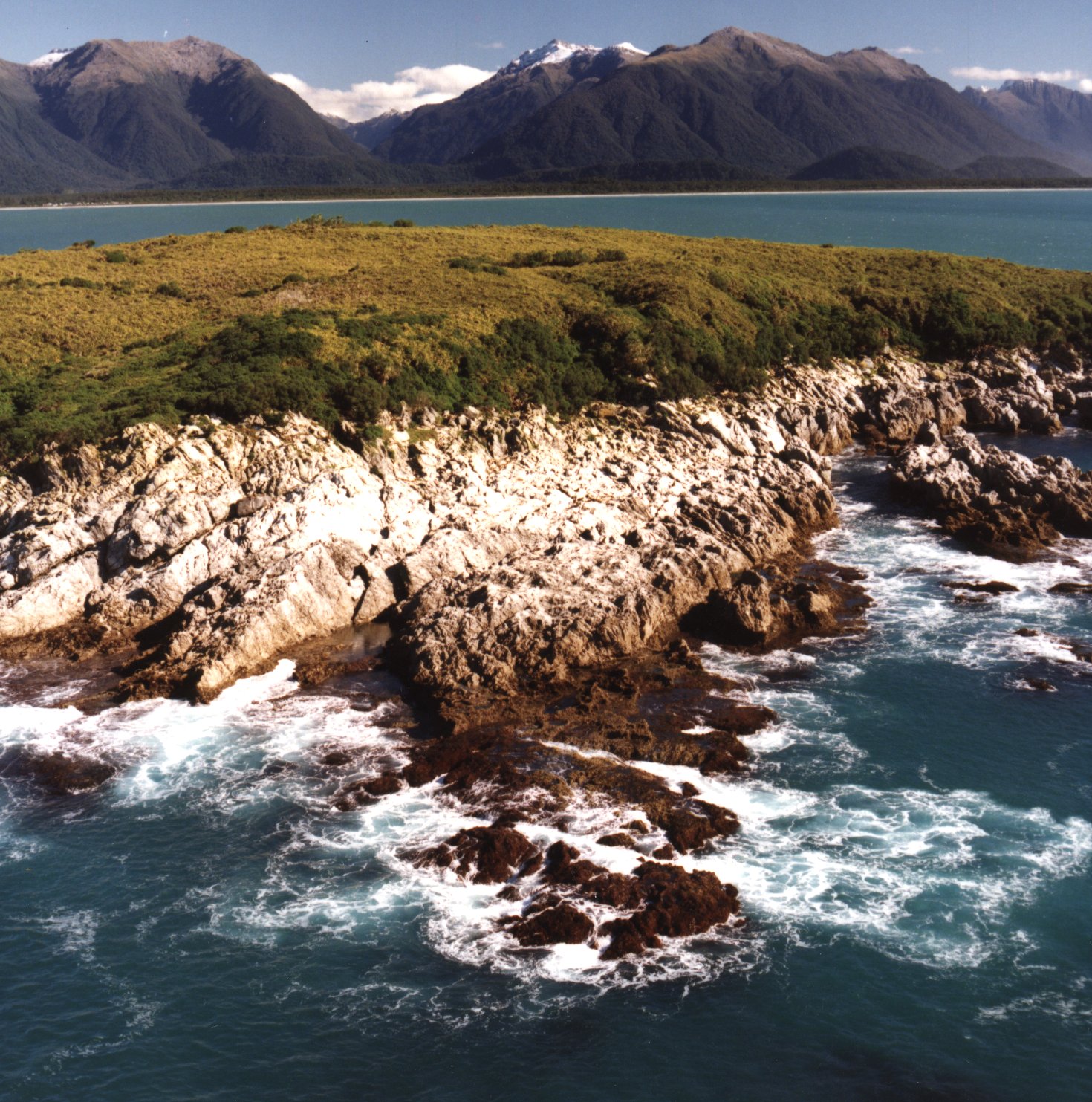
6. Te Ana Puta, Point Elizabeth
Thirty kilometres south of Punakaiki one comes to a major block of Tertiary limestone, the Cobden Limestone Formation. This formation underlies almost the whole of the Kumara - Moana district northwest of the Hohonu Fault, a major local fault running parallel to the Alpine Fault. The Cobden Limestone outcrops in a distinctive horseshoe with narrow steep escarpments and wider dip slopes that form the backdrop to Greymouth, largest town on the West Coast. A section of this escarpment, known locally as the Twelve Apostles, runs north along the coast from the Grey River to Point Elizabeth and forms the bulk of the Rapahoe Range Scenic Reserve which is managed by the Greymouth-Mawheranui D.O.C. office. In 1981 a New Zealand Walkways Commission "Walkway," based on an old track from 1865, was opened from Cobden's North Beach out to Point Elizabeth and then on to Rapahoe. Until about 1905 this used to be the main route further north.
Extensive searching of old newspapers and government archives from this period and checks with many locals reveal that while the goldminers knew there were caves in the Point Elizabeth area, their whereabouts were not recorded. The sea-caves just south of the Point were probably noted but even in those days it was too dangerous to go round this way, even at low tide. The gold miners used the Maori route that went across the back of the headland well away from the Point so that it wasn't until the 1990's that the big sea-caves just south of Point Elizabeth were fully explored.
Te Ana Puta or "the cave with the escape holes," only became fully known after a chance chat in the Rapahoe pub between the author and a local whose uncle had been into the cave via the sea entrance years ago. The main or No.1 Sea-cave entrance, noted on the 1911 Geological Map by P.G. Morgan, is in fact quite noticeable from seaward but access via this route is limited to occasions when the tide is dead spring low with a flat sea. While this is not very often - at best twice per year - it did occur just after the "chance chat" and so the hunt was on.
Between 1991 and '95 members of the Poutini Potholers explored over a kilometre of quite sporty cave which is located in the Tarapuhi Limestone member of the Cobden Limestone. This limestone also forms the distinctive offshore stacks - the Needle, Big Rock and Shag Rock - which are home to shags, seals, seagulls and a large flock of starlings. The first trip into the cave via the sea entrances revealed a tomo which took four months to find from the track, the bush being incredibly thick and slow going. Eventually six tomos or "escape holes" were located and mapped and there are still more. At the bottom of most of the tomos there are bones, both moa and cow, (hence the Kneecow Tomo!) all of which have been left in situ.
There is no streamway in the cave, instead there is a tidal section mapped as "The Lakes" where fresh water running into the cave from above and seawater entering via the tide, meet. The depth of water through this section is very variable, depending as it does on tide level and rainfall. Sometimes it's impassable and at others only knee deep, but whatever the state the mud and sideways travel along the 30o dip slope make for a very wet and slippery trip.
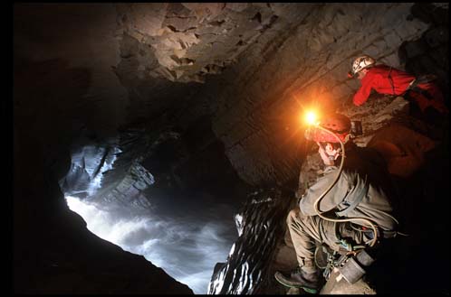
Another problem can be the airwaves that draft strongly through the cave when the sea is rough at high tide. Waves slam in through both sea-cave entrances causing constant changes in air pressure that can give one quite sore ears, while the nearest tomos become blowholes and "breathe" quite gustily. A rope once chucked down the Bentpot Tomo in readiness for abseiling came right on back up again. The most popular trip into this cave is probably the one at high tide via the Bentpot to see the sea-cave doing "its thing" (see photograph) rather than a through trip at low tide. The noise and light effects can be pretty awesome.
Whatever trip one takes underground this cave runs along right under the Point Elizabeth Walkway with all the tomos being only 30 - 50 metres off the track. With up to 20,000 people going through the track per year the Department of Conservation and local cavers have kept fairly quiet about Te Ana Puta as it is not a place for beginners. The chances of slipping down a tomo or being lost in the bush or cave are quite high. Two search & rescue exercises have been carried out to establish the best routes for getting an injured caver out but given the difficult in-cave travel one would hope that this never happens. The local boat tour operator who runs trips out to the Point area to look at Hectors Dolphins and the other wildlife, points out the sea-cave entrances but generally keeps "mum" about the cave proper. At Te Ana Puta, the dilemma about "keeping quiet or going public" is very much to the fore.
 |  | 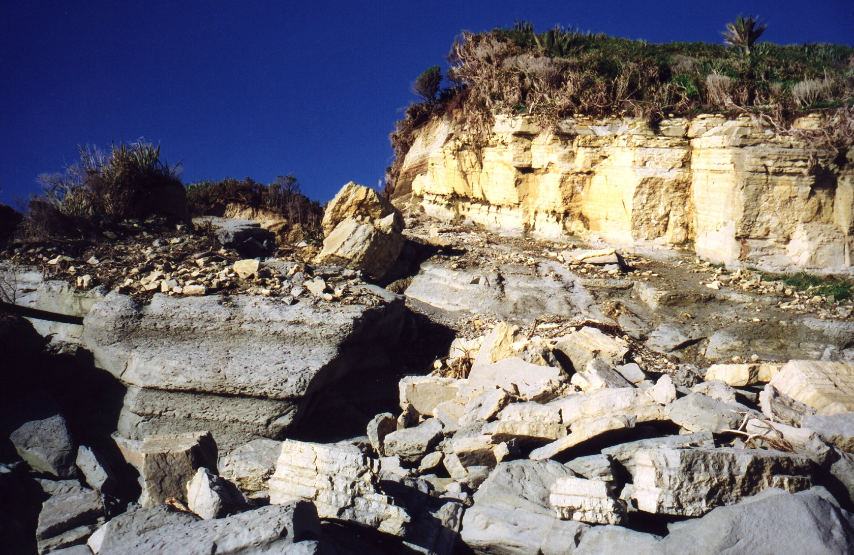 |
| Looking from the northwest back across Taumaku to Okuru and the Turnbull River valley. Photograph by Shane Hall, Area Manager, D.O.C. Greymouth | One of the two large sea-caves between Jackson Head and Smoothwater Bay Photograph by Bob Cannell of Round-About-Haast Tours | Massive erosion after big storms in 2001, of the Puketahi Mudstone layer of the Cobden Limestone Formation 400 m south of Te Ana Puta Cave |
7. Abbey Rocks and the Lithographic Quarry
There is a long gap now down the coast from the Taramakau River to the Paringa where there is no coastal karst and very few sea-caves of any kind. Repeated glacial action in the recent past has covered much of the coastal plain with glacial gravels along this section of coastline, masking any underlying sedimentary rock including limestones. However south of the Paringa River there was less glaciation so that sedimentary strata of one kind or another, are now found all the way south to where the Alpine Fault crosses the coast near Milford Sound.
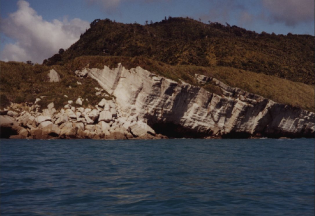
A band of Eocene limestone, the Abbey Formation, outcrops on the north side of the Paringa River mouth and then runs south in a thin band behind the coast to outcrop about 10 kilometres further south at a place known to Maori as "Pau-a-rek" meaning 'sweet shellfish' (European mis-spellings are Paureka or Pawa Riki). The offshore outcrop of sea-stacks and reefs is known as Abbey Rocks while the onshore outcrop became a quarry site in the 1870's.
The middle and lower strata of the Abbey Formation are atypical for West Coast limestones with both being described by geologist Simon Nathan in his 1976 Government Survey as quite fine grained. The lower strata is also, "well bedded, creamy white, highly foraminiferal in a micritic groundmass, and in places extensively deformed". This is far more akin to Amuri Limestone, also Eocene, which is found extensively east of the Southern Alps in Canterbury and Marlborough, than to other Tertiary limestones found elsewhere on the West Coast. This difference, and the rock's potential, were quickly recognised by early prospectors.
The first known people on the scene were prospectors William Docherty and Richard Arthur in November 1873. They quickly recognised the lithographic potential of the rock and during the following year took out a lease on the area, floated a company - "the Pawa Rika Lithographic Stone and Land Investment Company, Ltd." - and shipped in the necessary materials to set up a quarry, camp and jetty for ships to take off the stone. By the time Government Survey geologists Herbert Cox and Alexander McKay visited the site in January 1876, samples were being hewn from blocks of rock at the back of the beach in readiness for shipping to Melbourne for evaluation and to the Philadephia Exhibition for display.
Unfortunately closer scrutiny at Melbourne showed the rock was not quite up to the standard of the better known (at the time) German lithographic limestones and between doubts about the quality of the stone and the economics of the venture, the project was shelved although at least one lithograph was made by Harrison and Co. in London between 1875 and 1880. This was of the S.S. Waipara loading lithographic stone near Abbey Rocks and the quality of the prints shows that the Abbey Formation limestone really did have real potential. Further proof of this has also been shown during the 1980's revival of interest in lithographic printing techniques at the University of Canterbury's School of Fine Arts. Samples of the German Solnhofen Limestone, of Amuri Limestone and Abbey Formation Limestone were analysed by chemical analysis and electron photomicrographs which showed that while the German stone is still best, the other two are well in the running. If Abbey Formation rock were more readily available and in good quantities, it could still be used for fine lithographic work today.
After another abortive attempt to revive the quarry in 1906, when more stone was collected for the Christchurch Exhibition, the site was abandoned. The leases, then ownership of the land changed hands over the years and by 1957 none of the title plans of the sections in the general quarry area had "quarry" marked on them. By 1976 when an Archaeological Site inspection was made, the quarry site could not even be found although some old wagon wheels, well corroded, were located and then left in situ. In 1995 D.O.C. acquired the land the site is on and today the only reminders that Pauareka ever existed are a set of spoked tram wagon wheels at the back of the beach, an old photograph of the stone jetty in the Hokitika Archeological Sites register, copies of the S.S. Waipara lithograph in the Hocken Library in Dunedin and the Hokitika Museum and of course the Abbey Rocks. The actions of the sea, the heavy annual rainfall and the dense bush have all but swallowed up the site of what was once somebody's pipe dream.
8. Arnott Point Area Volcanic Caves
Travelling on down the coast one crosses the Moeraki River, closely followed by the Whakapohai, and after this is a rough stretch of coastline backed by terrain extremely difficult for roadmaking, so difficult that for many years the road finished at Lake Paringa. But post World War II the roadmaking began in earnest with first the road over the Haast Pass being finished and then, in 1965, the northern link. The chosen coastal route, whilst very scenic, provided many headaches for the engineers and even today there are constant slips along the section south of Knights Point near Breccia Creek. Much of the severely deformed rock in this area dips steeply and is prone to erosion.
When tourists stop in droves at the Knights Point Lookout to view the scenery southward over Arnott Point they have little idea of the Maori and sealers who've been there before them or the dramas that went with the road making. Most know nothing either of another drama that was once enacted outside the small cave at Arnott Point or of the almost hidden sea-cave near Breccia Creek. They go away, after admiring the view, perhaps reading the interpretation panels, wondering maybe who Knight was (a dog actually!) and looking for-ward to their cappuccinos at Fox Glacier.
Both of these caves are in a Paleocene volcanic rock, the Arnott Basalt, a localised formation of black rock interbedded with volcanic tuff and breccia containing abundant interstitial calcite and zeolite. The overlying tuff and breccia is also highly calcareous in places. Poorly preserved foraminifera found in the base of the basalt indicate that the rock was probably deposited up through the underlying Whakpohai Sandstone Formation from several volcanic vents under the sea, the main one being near the present mouth of Breccia Creek. Access to both caves is only feasible along the beaches when the sea is settled and at low tide. Even then the going is fairly slow on steeply shelving sand and around rocky bluffs.
The cave at Arnott Point was the site of a major altercation in 1826 between a sealing gang and local Maori. The fight, long remembered by Maori, was well documented by one of the sealers, an American John Boultbee, in a diary that has proved an excellent primary resource for those researching both early New Zealand and Australian history. Boultbee's gang was one of four put ashore in April 1826 at George Sound, Fiordland, by Captain John Kent out of Port Jackson, New South Wales. With instructions to head north they sailed and rowed their open boat to their base at the Open Bay Islands, taking only a few days.
By this time there were few New Zealand fur seals anywhere along this coast due to the excesses of earlier sealing expeditions. However working hard, Boultbee's gang were able to procure a few here and there. On the fateful day they had rowed even further north to the area around the Whakapohai River mouth but on the return trip one crewmember was too tired to row back out to the Open Bay Islands. Despite knowing there were Maori in the vicinity, the gang decided to sleep in the cave that was well known to some of them.
At this stage relations between the resident Maori, some of them displaced persons from wars between the various tribes on the east coast and self exiled to the West Coast, and the sealers were not good and there had been cases of unwarranted violence on both sides. Knowing this the sealers took some precautions but the Maori band attacked well before first light and fully surprised the sleeping sealers. After a desperate fight, where the Maori used lances and the sealers an oar and muskets, the latter launched their boat safely leaving behind two dead, one of whom was the man too tired to row back to the islands.
The cave itself is relatively small, although as Charles and Neil Begg found when researching their book, the World of John Boultbee in 1978, quite large enough to shelter the six men in Boultbee's gang. To visit the cave, which is right at Arnott Point, they walked south along the beach at low tide from Murphy Creek. In their own words they found it "about 1.5 metres high at the entrance and 3 metres wide. Inside the ceiling rose so that is was possible to walk erect in the main compartment which extended 3-4 metres into the cliff. Fragments of seaweed and a few small pieces of driftwood on the floor suggested that a high spring tide might reach the cave." Once their eyes were accustomed to the low light they also found seal bones and an old boot that they thought probably belonged to a more recent cave user.
The second cave in the Arnott Basalt is located about a kilometre further south where Breccia Creek spills over a small waterfall to meet the sea. Gerry McSweeney, owner of the "Wilderness Lodge" at Lake Moeraki, told the author about this and a visit made on the way home from an Easter caving trip to Jackson's Bay in 1994. Access to this cave is better from the south, travelling north at low tide from Cole Creek. On the '94 visit it was found that a big rock fall has all but covered the cave mouth that is only a metre or so to the right of the top of the waterfall. One has to climb up about 8 metres over large but stable rocks, to squeeze through a metre diameter hole. Then it's back down the rocks on the inside to find a 4 metre wide cave which one can walk about in and which goes back at furthest about 10 metres.
With its level sandy floor this cave is probably a better shelter than the one at Arnott Point although not a place to be ambushed in! Despite being formed in basalt there are small stalactites up to 5 cms. long growing from the roof in a number of places, deposited from the water percolating through the overlying calcareous tuff and breccia. On the floor were two (seal?) bones and here too there was an old boot. Perhaps the pair to the one at Arnott Point?
9. Open Bay Islands
The next karst one comes to forms the Open Bay Islands that were named by Captain Cook back in March 1770 as the Endeavour beat its way up the West Coast. These are located some 30 kilometres further on down the coast from Arnott Point and about 10 west of the Haast river mouth. Of the two islands Taumaka is about twice the size of the smaller Popatai, being 658 metres long by 258 wide and both are only just over 20 metres above sea level at highest. The islands and reefs are all formed of a creamy-yellow Oligocene Limestone, much folded and weathered into a hard, almost brittle rock, razor edged where exposed. Both islands are also capped with a layer of glacial gravels and in places, glacial erratics.
Steve Attwood, formerly media spokesman for the Department of Conservation at Hokitika, accompanied other staff on a seal counting trip to the islands in 1994 and wrote up his experiences in an article for the Christchurch Press. He described Taumaka as "covered in a dense tangle impenetrable kiekie with a narrow border of scrubby bush giving way to the rocky shore. On the east side the rocks form vertical cliffs plunging into a deep, clear sea. On the west, however the limestone lies in flat beds, eroded by the sea into sheltered inlets, deep pools, and rocky shelves which form an ideal haul-out, mating and birthing place for hanata (seals)." In the early days the sealers found these shelves difficult to haul their whaleboats across but they preferred using the islands for a base rather than the mainland, as there were no sandflies or mosquitoes.
Whether there are caves or not is unknown (although suspected) but given the limited height of the limestone above sea level, any there are could not be extensive. According to Don Neale, West Coast Conservancy Marine Officer, who visits the islands for the annual seal counts, there's probably more scope for underwater caves. He says that a large, deep slot at the southwestern end of Taumaka is well worthy of exploration. Steve Attwood also commented on possible caves in his Press article when he wrote that amongst the "cacophony of noise" on the island (from the sea, the seals and the birds), there were "deep woofs of trapped air exploding out of caves along the tide line."
In the early 1990s ownership of the islands was returned from the crown to local Maori so that visits to the islands are now off limits to the public. However as the owners are happy for the island to retain it's Wildlife Refuge status there are occasional trips out there by scientists and D.O.C. staff to conduct various studies and there is still a hut on Taumaku for their accommodation. The islands once more have a good size population of N. Z. fur seals, a protected species since the 1940's, while Fiordland Crested penguins, gannets, terns, shags, shearwaters and noisy sea gulls all form a large bird population. Occasionally tourists come out to the islands from nearby Okuru by boat or helicopter to view the wildlife, although they cannot land. Not only a refuge for wildlife but for a remnant of karst that has survived several periods of glaciation in the not so distant past.
10. Caves of the Far South: The Frenchmans Gold
From Jackson Head at the southern end of Jackson's Bay a band of Oligocene limestone runs parallel to the Alpine Fault, now much nearer the coast. Sometimes the limestone outcrops on the coast as at Jackson Head or the south end of Big Bay while in other places it outcrops inland. The last small coastal outcrop is near Madagascar Beach just north of Milford Sound where the Alpine Fault crosses the coast and heads out to sea. However wherever the limestone is, exploration in this part of the world is much more difficult than further north because the coastal road runs out at Jackson's Bay while the inland one finishes at the Cascade River. The only access further south is by tramping on down the coast, by light plane to Big Bay Beach or the inevitable helicopter to just about anywhere.
The few people living in the far south are either fishermen like those at Barn Bay, families who like the solitude such as the Longs at Gorge River, white-baiters in season at Big Bay or Hollyford Tourist Company employees at Martins Bay. Generally the area is remote and sea-caves are more likely to be seen by the occasional sea-kayaker paddling up the coast or fishermen out of Milford Sound or Jacksons Bay, than anyone on foot. Perhaps the lack of people and the sheer difficulty of terrain is the reason that no one has ever found the "Frenchman's Gold," supposedly lying in a cave here, somewhere.
Space here is too small to give more than an outline of the many versions of this story but interested readers should read Chapter 6, "The Frenchmans Gold," in Ian Dougherty's 1996 book, Arawata Bill, which outlines most of them. William O'Leary (1865-1947), better known as "Arawata Bill," was an old time prospector and local legend that lived and worked in South-Westland - West Otago from about 1885 to 1940. He spent a lifetime searching the backcountry for minerals, mostly on his own, only spending the odd season here and there working for wages when he needed tucker and company. An emphatic believer in the existence of the Frenchman's Gold, he was always on the lookout for clues but despite a lifetime of looking he died without finding it, having added in his own inimitable way to the stories which many people, even in the early days reckoned were just that, stories.
What's most interesting for cavers is that the gold was supposedly stuffed in a sea-boot and stashed in a cave "somewhere near the mouth of the Cascade River" because it was too heavy to carry. Just who was carrying it also varies: some versions have French mutineers while others have convicts, escaped from Australia with stolen gold and no "French connection." Dates for the episode also vary all the way from the 1830's to the 1890's although most versions agree that those who stashed the gold were shipwrecked or jumped ship and once ashore found themselves so far from any settlements and in such dire straits that to save their lives they ditched the gold. One version has one of the French mutineers passing on a map to others on his deathbed while another has a story about a slip having come down over the mouth of the cave, perhaps started by one group who actually mounted an expedition to look and who went home empty handed.
So where is the cave? Some stories say that it's inland while others don't specify. In the early days most foot travellers kept by the coast so why the gold would be inland is uncertain although one version has the party sailing their small boat up the Cascade after escaping the French ship. In some versions Brown's Refuge - about a day's tramp south of the Cascade and one place where limestone outcrops on the coast - is quoted as the place where the pirate ship was wrecked, in others where the mutineers came ashore. Having read all the stories she can lay her hands on, the author is, in many ways is none the wiser, although she does know the treasure is not in the caves at Gorge River as a letter received in October 2001 from the one resident family has revealed.
Robert Long, otherwise known as Beansprout (another story!) has lived on and off at the Gorge River for 20 odd years and knows the area well having found a number of Maori artefacts near his hut and walked north many times to get provisions and mail (only about 5 months for a letter turn around from Runanga!) According to Robert, just across the river on the north side there is a there is a large limestone overhang facing the sea which is often used by hunters and trampers while in the bluff behind, facing north is a respectable size cave. In his letter he says "there are stalactites and stalagmites inside the cave which is about a 100 feet from the large entrance to the back of the cave where there are pools of water. There are some seal bones fixed in the limestone. But unhappily no sea-boot full of gold.
The most sensible comment the author has found is in Neville Peat's book Cascade on the Run, which is a history of the annual white baiting ventures of the Buchanan family at the mouth of the Cascade River over the period 1940 to 1975. As with almost every book ever written about South Westland, Peat includes a version of the gold story, with his being called the "Frenchman's Den." However he also says that the Buchanan family didn't put much credence by all the stories: for them the "white gold" of the annual whitebait runs was much easier to come by than any searches for the real thing, In fact he writes that Bruce Buchanan "doubted that the mutineers came ashore at Cascade at all on account of the surf. Homminy Cove, near Jackson Head, was a more likely landing spot (in Bruce's opinion). It is sheltered from the south-west swell and is better endowed with caves than the Cascade."
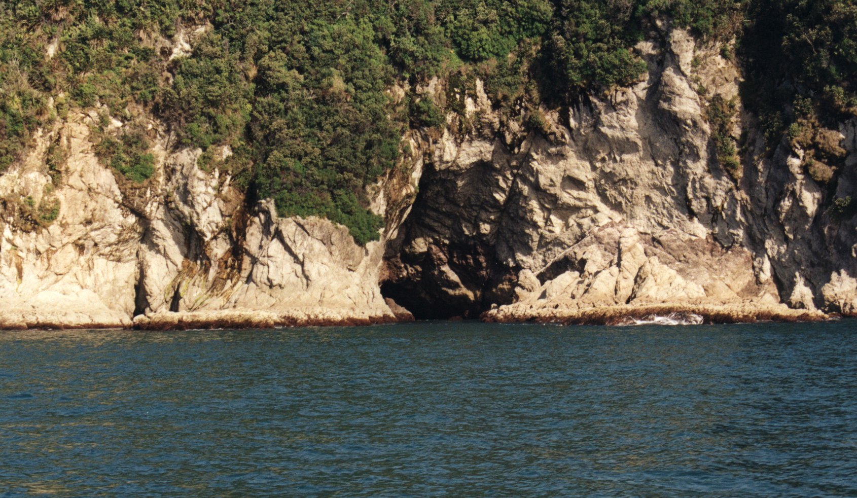
There are other choices too. A bit further north again there are two large sea-caves in the limestone cliffs between Smoothwater Bay and Ocean Beach, just south of Jackson Head (see photograph). Both caves are quite large and reach well back into the cliffs. One or the other must be linked to Serendipity Cave, back up in the hills behind the cliffs, whose main streamway closes down so that is impossible to follow on down. Serendipity, which is now a registered Archaeological Site, was only re-discovered in 1965, having been much used by Maori in the long distant past. But the Otago University tramping party who stumbled across it found no boot full of gold there either.
(Perhaps those of you intending to come to the 2005 ACKMA. Conference here on the West Coast might be interested in an excursion to find the Frenchman's Gold, something a little different from the usual post-conference trips. And like all good bullion seeking expeditions you might even need to put some money up front, for costs and the such like. $500 per head should cover it, so to those ends please send all cheques to the author ... cash of course.)
The Management Perspective
There are two types of impact on sea-caves and coastal karst, the elemental type and the human type. Dealing with the former is straightforward: the elements will continue on their merry way, eroding the coastline, the sea-caves, the karst. Dealing with the second, which is probably the lesser of the two "evils" long term, is a different story.
Because New Zealanders, like people the world over, are inclined to impact very unfavourably on their environment, their behaviours need constraining by clearly set down laws. To that end therefore this country, with it's very long coastline has a comprehensive management system in place which does help to keep most of the places which are the subject of this study, "in some form of care" - away from exploitation and development. Of course being structured by humans the laws are not foolproof
An instance of this has arisen recently right here on the West Coast. Despite being drawn up only recently there is a loophole in the West Coast Regional Council's Regional Coastal Plan which is allowing the commercial exploitation of stone from West Coast beaches: white rock (quartz) fetches a good price in Auckland garden shops. Who is to say that some aspect of one or more of the sea-caves or coastal karst we treasure is not going to become commercially viable in the future? Will "they" want to quarry our cliffs for cement making or for some mineral we barely know of as yet? We can only hope that what is currently in place in New Zealand will cover the unexpected in the future.
Basically the management of all of New Zealand's coastline comes under the brief of the Ministry of Conservation expressed generally through the New Zealand Coastal Policy Statement. Key Acts (there are some others) that cover much of the coastal management are the Conservation Act of 1987 and the Resource Management Act of 1991. The former is carried out by the various D.O.C. Conservancies around the country while the latter is carried out by the various Regional Councils. Under Section 64 of the R.M.A., each Regional Council must have in place a Regional Coastal Plan. For this article most of the 800 kilometres of coastlines comes under the jurisdiction of the West Coast - Tai Poutini Conservancy and the West Coast Regional Council: however the far north, between Cape Farewell and Kahurangi Point coast is looked after by the Nelson Conservancy and the Tasman Regional Council.
For the West Coast - Tai Poutini Conservancy the combined efforts of D.O.C. solicitor Dean van Mierlo, Marine Specialist Don Neale and Land Management Officer Ian Gilbertson came up with the following points about the management of sea-caves. The author's question to D.O.C. about management returned an answer far from straightforward - in fact the email from Deborah Carden, ACKMA member at D.O.C.'s Buller Office said "it's a real maze." So:
- If it's conservation land to the cliff face, any sea-caves would "most probably" be D.O.C. administered, especially if the cliff is vertical. Sometimes the boundary would be to the Mean Low Water Springs or some other line. (doubts already)
- If there is private land or other agency land to the cliff face (eg District Council), and the cave is somewhere between the top and bottom of the cliff, the ownership of that cave would lie with that person or agency, if the cliff is vertical. Traditionally ownership of land includes ownership of the space from the surface through to the centre of the earth, and from the surface to the 'heavens' - you cannot sue NASA or an airline for trespassing in your air space. (what if it's not vertical?)
- If a cave is at the bottom of a cliff that water enters at high tide, ownership would need to be considered on its merits. Land up to high tide is normally Crown land administered by the Ministry of Commerce or the Regional Council. But if it's private land that makes this difficult - each instance must be considered on its merits. Seawater in a cave is usually taken to be part of the coastal marine area. An example is the Pancake Rocks surge pool where the land is conservation land but the sea is probably considered to be coastal marine area (and thus probably under Regional Council management or then again maybe not).
- D.O.C. has management responsibilities too from the Mean High Water Spring Line out to the 12-mile limit. This is in conjunction with the local Regional Council (as stated above they have joint responsibility). Some foreshore is privately owned, some owned by port companies as well and there are Treaty claims as well to foreshore and land above high mean tide. Coastal erosion and accretion can confuse this issue even further (room for loopholes here ...)
- The Foreshore and Seabed Endowment Revesting Act gives DOC the Crown's 'ownership' role for the foreshore and seabed from MHWS out to the 12-mile limit, which is the "Land of the Crown in the Coastal Marine Area' (not conservation land). This Act carries some administrative and management responsibilities.
The West Coast Regional Council's responsibility is to ensure that the terms of the Resource Management Act, particularly the specific provisions of Part II regarding coastal marine areas, are carried out through its Regional Coastal Plan. As part of the Plan the council must provide a framework to promote the integrated and sustainable management of the West Coast physical resources while at the same time safeguarding against activities that could have adverse impacts on air, water soil and ecosystems.
Working through the Plan a quick analysis shows that Section 5.1 lists these four key areas:
Coastal Protection Areas Culturally Significant Areas Coastal Recreation Areas Coastal Development Areas
However these criteria protect only three of the select study karst areas: i.e. Perpendicular Point (plus it's sea-caves which are also archaeological sites), the Punakaiki Pancake Rocks area and the Open Bay Islands. The first two are listed as Culturally Significant while the last that is a Wildlife Refuge, is a Coastal Protection Area. In particular the Coastal Protection Area criteria tends to protect estuary and lagoons, wetlands and beaches rather than clifflines or rocky areas. Only some much protection here.
However it does get better because in section 6.1 which deals with Cross Boundary Issues, i.e. where what happens under the jurisdiction of one agency has affects in another r downstream) the criteria do offer more protection to sea-caves and coastal karst. This Schedule allows for the integration of management across boundaries, mostly with D.O.C. and the three West Coast District Councils. Of the three key areas identified here:
Marine Mammal & Bird Sites Coastal Hazard Areas Outstanding Natural Features and Landscapes
the last is the one where a number of sea-caves featured in this article are located, e.g. "The Wineglass" near Kongahu Point, the Island Sandstone and sea-caves of Perpendicular Point, the Pancake Rocks at Dolomite Point, Te Ana Puta at Point Elizabeth and the sea-caves and karst from Jackson Head south to Big Bay. This is more reassuring.
Finally the Regional Coastal Plan, Section 5.6, also states that, "the WCRC will notify the N.Z. Archaeological Association of all applications for coastal permits which are likely to adversely affect any archaeological sites and historic places identified in the N.Z. Archaeological Association's database." In other words the Archaelogical Association would be drawn into the fray too were there to be any applications for a resource consent to start some form of extractive industry. No real regulatory teeth but it does help.
 |  |  |
| Te Ana Puta from seaward showing from L to R: the First and Second Sea-cave Entrances. The main cave is located in the block of Cobden Limestone up behind the sea-cave entrances | Te Ana Puta - Looking down into the Second Sea-cave entrance from the "cave proper" Photograph by Alan Pryke - Sydney University Speleo Society | Abbey Rocks, courtesy of D.O.C. Collection, Fox Glacier Field Centre |
It is also reassuring because many of the selected study sites such as the Maori Artefact caves at Patarau - Sandhills Creek, Fox River Sea-cave and the Abbey Rocks Quarry Site are registered with the New Zealand Archaeological Association. The West Coast-Tai Poutini Register is kept at the D.O.C. Conservancy Head Office in Hokitika while the register for the far north sites is in Nelson. Each location has it's own Site Record Form which notes key information such as type of site, which map it can be found on and a grid reference, who owns the land the site is on, who found the site, what was found and what has been done, if anything, with any artefacts. Some files have additional pages noting such things as repeat visits by archaeologists or changes of land ownership or photographs.
However you don't have to be a lawyer to realise that the elemental warfare is far more destructive than the paper warfare is protective. The latter may slow up the demise of some sites for a while but the former is slowly gaining the upper hand. It may be infuriating to find recent graffiti scratched into the walls of the sea-caves at the bottom of the Truman Track but a couple of big nor'west storms will soon scour that off again. Fox River Cave, which is so vulnerable, being right by a road and a small holiday settlement, has recently been transferred to D.O.C. management, but how will this stop the river and sea scouring out more of the sea and river entrances? Incongruously on the landward side the locals have built a neat set of concrete steps up to southern entrance and keep the grass mowed, all just 30metres from the nearest dwelling. All very tidy and responsible but toothless in the face of the elements.
This discussion has now come full circle because "in the face of the elements" on a rapidly eroding coastline (see photograph) one can really do no more than keep records and take photographs. The research for this article has been really interesting and will finally fill a book as there is much that is still unsaid, both about other sites and the human history angle. For the most part the local museums are dominated by records about European achievements in goldmining, coalmining, shipping and town development with a bit about the role of pounamau (greenstone) in the lives of early Maori. But there is little about the really early history of both groups, about the diaries of the first European explorers, few early artefacts, or archaeological finds and almost nothing about West Coast geology. Remedying this would be an interesting task for D.O.C., the Archaeological Association and the New Zealand Historic Places Trust. As with so many "good ideas" lack of funding would probably be cited as the biggest stumbling block. We can only hope.