INTRODUCTION
This brief article is an introduction to the long complex history of the Chillagoe District and is designed as an introductory stimulant for those hoping to attend the 15th ACKMA Conference in May 2003.
I have avoided technical jargon wherever possible on the assumption that many will not have a geological background.
The instigator for this paper was my good friend and colleague in science, Lana Little, the Conference Convenor. Some of what follows is directly relevant to karst development but some of the older history is only relevant in the sense of 'ground preparation'. It is however now apparent from research done in the district in the last 10 years that weathering and acidic fluid attack on the limestone/marble units of the current land surface extend back to about 300 million years. There may well be karst of this age but we have no definite age dating to confirm this.
The long complex history is divided below into five main timeslots and this is the same arrangement that I used to lay out a timeline of geological history for Chillagoe's Hub, a new interpretive centre, completed in 2002.
I have labeled the 5 main timeslots The Ancient Basement, The Palaeozoic Sea, The Great Folding and Melting Period, The Great Inland Sea and The Great Lake & Recent Highland Volcanoes. Each of these major periods are sub-divided in to a series of specific sub-events.
1. THE ANCIENT BASEMENT
Bearing in mind that the calculated age of the Earth is 4500 Ma (million years before present) and the oldest known Archaean age rocks in Western Australia & Greenland are 3800 Ma, the first known page in the local history book is relatively recent.
1700 - 1650 Ma. Palaeoproterozoic. Let us wind the clock back 1700 Ma. Our local region at that time was a shallow sea. Sand, silt and mud were deposited in the sea from the erosion of Central and Western Australia. Australia was being stretched away from another continent to the east thought to be North America. The stretching process opened up a submarine rift valley, analogous to the present day Red Sea Rift, between the old Australian block to the west, and an unknown continental block (possibly North America) to the east. Sediments were deposited from erosion of the continents and magma from deep in the earth's mantle rose to the surface to form submarine basalt volcanoes.
1550 Ma. Mesoproterozoic. At this time an episode of compression folded these old rocks to such an extent that some were forced deep into the crust. The deeply buried rocks were changed by heat and pressure and some melted again. The magma rose into the upper crust where it crystallised to form granite bodies.
These are exposed at Dargalong on the road south from Chillagoe to Bolwarra. They are called "Dargalong Metamorphics" because they have been greatly changed by heat and pressure. Many of these rocks have a coarse-grained crystal structure resulting from slow crystallisation during deep burial. They are exposed at the surface because the crust domed up in a later period and the younger and shallower rocks were gradually worn off by erosion over millions of years.
1550 - 470 Ma. There is no record of rocks of this age range in the district - we assume this was a period of erosion of the continental mass.
2. THE PALAEOZOIC SEA
470 Ma - 370 Ma. Around 470 Ma (Ordovician) this region stretched again as two continental blocks started to pull apart. The stretched and thinned crust sagged down below sea level. The western boundary between the land and sea was the major regional Palmerville Fault. The eastern edge is less well defined but may have been the Kuranda Range. This was much like the modern Red Sea between Africa and Arabia - a long narrow sea bounded by long straight faults. Sediment washed into this shallow sea as gravel, sand and silt.
Around 420 Ma (Late Silurian) molten basalt lava rose to the surface and formed underwater volcanoes. Coral reefs grew around the rims of these volcanoes. Hot springs deposited iron, zinc, copper, and lead sulphides and some gold in an underwater setting like the Black Smokers in today's ocean basins such as in the Red Sea. These metal sulphide deposits have been found and some mined at Mungana, King Vol, Mt Molloy, and the Dianne Mine. The main sequence of sediments is known as the Chillagoe Formation and all the karst in the district is contained within this unit. A much higher proportion of sand was deposited as the basin deepened in the Early Devonian (410 Ma to 390 Ma) and the amounts of lava and coral reefs decreased.
Corals, shellfish, radiolaria, worms and crinoids were preserved in the rocks as fossils. The lava and limestone are exposed in a long belt from north of Palmerville, through Mount Mulgrave, Chillagoe, Almaden and on to Mt Garnet. The sandstone occupies much of the area to the north and east of Chillagoe around the Hodgkinson, Mt Carbine, Mt Molloy and Mareeba areas.
At about the same time, magma rose along deep fractures in the Dargalong Metamorphics and crystallised as granite, kilometres deep in the earth. An example is the Nundah Granite exposed along the Bolwarra road around Muldiva Creek. Fluids associated with these granites introduced gold.
 |
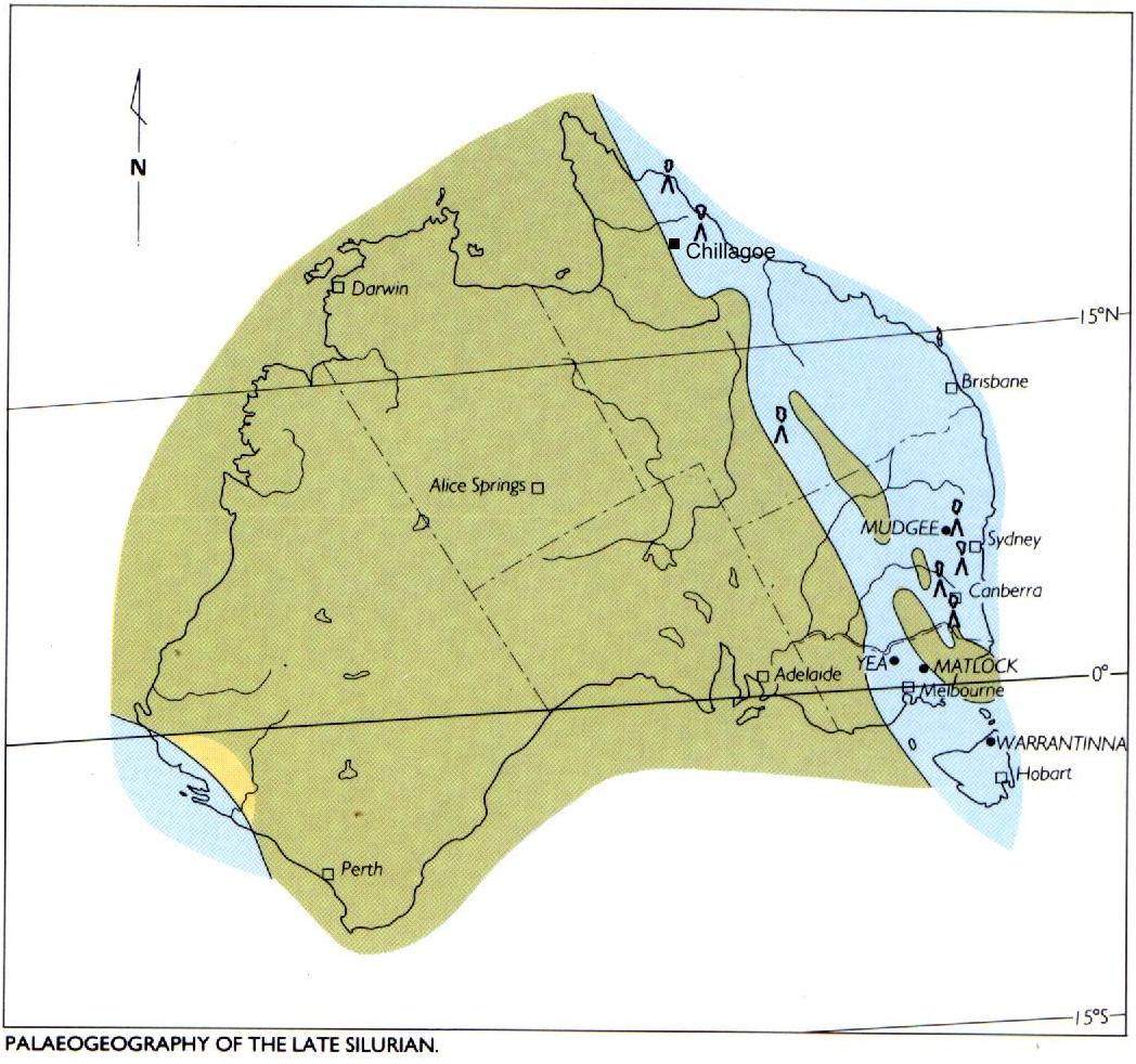 |
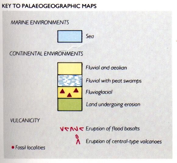
Figure 1: Key to palaeogeographic maps |
Figure 2: Australian palaeogeography in the Late Silurian |
3. THE GREAT FOLDING & MELTING PERIOD
370 - 325 Ma. Late Devonian to Middle Carboniferous. The continental blocks moved together again and compressed the submarine basin rocks. The Dargalong Metamorphics were thrust up towards the northeast over the younger Chillagoe Formation along the Palmerville Fault. These formed a long mountain chain much like the Himalaya of today.
The rocks originally horizontal were folded like a concertina so that they were turned on end almost vertically. A network of branching faults dismembered the sequence into a series of fault slabs. The total thickness of the Chillagoe Formation when horizontal was about 1 km. The thrusting of the fault slabs into a stack has produced a pile up to 10km thick.
The Chillagoe Formation limestones had been deposited as fringing reefs surrounded by thin horizontal sheets of limy reef debris. The folding of the limestone sheets into a near vertical position has produced the long narrow bluffs that we see today. Steep banding in the rocks is evidence of the once horizontal layering. Many of the fossils are similarly layered.
325 - 315 Ma. Middle Carboniferous.
The folded rocks were stretched again. Magma formed deep in Earth during the previous compression phase domed upwards often along faults. Some crystallised as granite several kilometres deep in the earth. Some erupted at surface as very explosive volcanoes, similar to modern volcanoes such as Mt Saint Helens in the USA. The granites contained much tin, which formed mineral deposits such as those around the Tate River, Herberton and Irvinebank. The granites heated the limestone and introduced fluids into the surrounding rocks forming marble and garnet-rich rock called skarn.
315 - 310 Ma. Late Carboniferous. A new episode of squeezing and folding commenced as the granites and volcanoes were cooling. This time the compression was oriented north-south. Many of the faults and folds ran in an easterly direction. Gold deposits formed in and around the hot igneous rocks, such as at Red Dome near Chillagoe. Long thin quartz veins with rich gold crystallised along fault lines. A good example of these narrow veins can be seen at Tyrconnell.
310 - 300 Ma. Late Carboniferous. The region was stretched again. The Palmerville Fault linked with others to form a fault extending from Chillagoe to Newcastle in NSW a distance of 2,500 kilometres. Magma rose and more granites and volcanoes were formed. The main copper, lead, zinc lodes such as the Red Cap and Ruddygore mines near Chillagoe formed at this time. Large tungsten, molybdenum and bismuth deposits such as Wolfram Camp and Mt Carbine also formed on the edges of granite bodies.
From 300 - 280 Ma. Early Permian. The entire continent rotated slightly in a clockwise manner. The area east of the major Palmerville Fault moved more rapidly than in the west, so that dextral (right-handed) movement occurred. Major volcanic activity continued with a huge volcanic caldera forming to the north of Chillagoe in the Featherbed Range area. The name "Featherbed" is clearly an example of bush humour as the range is hard and 'bony', has very poor soil development and low sparse scrub. Prior to the outpouring of the volcanoes, hot springs and geysers were active in the Chillagoe area surrounding the volcanic centres. The first stage of karst cave development had begun in the exposed limestone rocks.
The volcanic eruptions of the Featherbed Range north of Chillagoe occurred over a period of about 20 million years from 300 to 280 million years. These were very major eruptions in global terms. The total volume of preserved volcanic rock is 1600 cubic kilometres, so it is estimated that 2000 to 3000 cubic kilometres of volcanic ash and lava blasted onto the surrounding country. Compare this volume with the Mt Saint Helens, USA event of 1981, which erupted just over one cubic kilometre of material and caused deaths and havoc over an area of hundreds of square kilometres.
Four overlapping volcanic centres are recognised in the Featherbed Range, but at least 5 earlier volcanic centres from the 325 to 300 million year cycles are recognised in the surrounding district. The Featherbed volcanic rocks are preserved in calderas, broadly circular collapse structures. There were 3 stages of development that led to what we see preserved today.
The first eruptive stage produced a line of 4 conical shaped volcanoes and surrounding sheets of thick volcanic ash covering several thousand square kilometres.
The second collapse stage developed because of the emptying of the magma chamber below the volcanoes as the eruptions occurred. The central part of the volcano gradually collapsed into the hole produced by the erupting ash and lava. The collapse calderas are broadly circular in shape with a diameter of up to 30 kilometres, and were commonly filled with water to form a lake.
The third erosion stage produced the shapes we see today over many millions of years. Erosion has stripped off a vast thickness of the volcanic material and washed it down the Walsh and Mitchell rivers to the sea. My research indicates that almost all of surrounding sheet of volcanic ash was eroded away before the start of deposition of the Carpentarian Basin at 140 Ma.
All that remains now is the central collapse caldera part of the volcanoes. This volcanic rock is harder than the surrounding basement rock and so is more resistant to erosion. This is why we now have a range of hills consisting of 4 circular shaped calderas.
280 - 255 Ma. There is no record of rocks of this age range in the district - we assume this was a period of erosion of the continental mass.
255 - 240 Ma. Late Permian. The climate for the period was very cold throughout Australia, with glaciers and ice sheets in many areas. The South Pole was located near Brisbane.
The Mount Mulligan area, 40km northeast of Chillagoe, was a rift valley bordered by faults and with a central shallow lake surrounded by peat swamps and forests. Decaying plants building up layer upon layer formed peat. As it was buried and compressed by thick sand, the peat became coal.
The sandstone and conglomerate form a spectacular mesa with subvertical cliffs of up to 200m. One of the most common fossil plants was Glossopteris. Mount Mulligan was the site of extensive underground coal mining until 1957. It was also the site of one of Australia's worst mining disasters. The entire underground shift of 75 men were killed in a coal gas explosion in 1921.
240 - 140 Ma. There is no record of rocks of this age range in the district - we assume this was a period of erosion of the continental mass.
4. THE GREAT INLAND SEA
40 - 70 Ma. Late Jurassic to Late Cretaceous. In this period the Carpentaria Basin formed to the west of Chillagoe. This very large shallow lake was deepest in the area of the present Gulf of Carpentaria. Global warming produced a major sea level rise in the Early Cretaceous to an elevation of 160 metres ASL. The lake became a shallow sea extending inland at least as far as Wrotham Park station near Chillagoe.
Coral, ammonites, and marine animals such as plesiosaurs and elasmosaurs (relatives of the dinosaurs) thrived in the warm conditions of this marine period around 100 million years ago. A fall in sea level towards the end of this period saw the freshwater lake system develop again.
70 - 30 Ma. Late Cretaceous to Early Tertiary. The eastern part of the continent upwarped to form the Atherton Tablelands highlands. The Tasman Sea, Coral Sea, Townsville Trough and Queensland Trough formed as New Guinea, Lord Howe Rise and New Zealand drifted away.
The Carpentarian Basin sediments were stripped off the Chillagoe area exposing the limestones once again to an extended period of karst cave development. Dinosaurs and ammonites became globally extinct due to major extraterrestrial impact and subsequent volcanic activity at the Cretaceous - Tertiary boundary around 65 million years ago.
5. THE GREAT LAKE & RECENT HIGHLAND VOLCANOES
30 Ma - 10,000 years. Mid Tertiary to Recent. In this period many basalt volcanoes developed in the Undara area and in a small rift valley between the Kuranda and Herberton Ranges on the Atherton Tableland. The most recent active volcanic craters are as young as 10,000 years ago. They are at Lake Barrine and Lake Eacham on the Atherton Tableland, and at Kinrara in the Undara area. Aboriginal people of the area would have watched these volcanoes erupt.
Throughout this long period, the area around Chillagoe was subject to continuous erosion. Extensive cave systems were developing in the limestone and marble. Some very interesting rare fossils dating to 2 million years were found in cave fill at the Tea Tree Cave. Fossils include an ancestral crocodile Quinkana and a giant wombat Phascolonus.
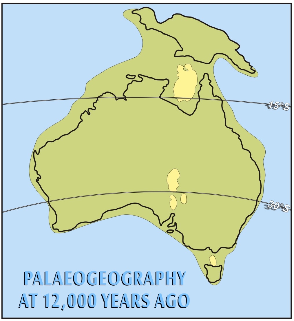
In the period 38,000 years to 10,000 years at the height of the last Ice age, the sea level dropped by as much as 140 metres from today's level. Dry land extended from Arnhem Land to Irian Jaya and from Cape York to Papua.
People could move easily backwards and forwards from New Guinea to Australia. The distance between continental New Guinea and the nearest Indonesian islands was only 100 kilometres.
The Gulf of Carpentaria became a large inland brackish to freshwater lake about 4 times the size of today's Lake Eyre in South Australia. This had a major effect on the plants and animals of the area. Major changes to the fish populations happened over this time. The hunting would have been much better than today and fresh water more bountiful.
 |
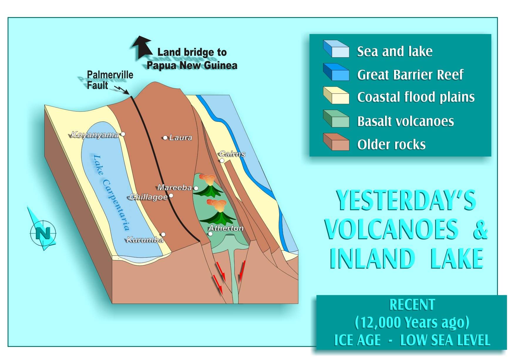 |
| Figure 3: Australian palaeogeography 12,000 years ago | Figure 4: Yesterday's volcanoes and inland sea |
KARST DEVELOPMENT
This summary of the Chillagoe district geological development shows that karst was developed over three significant time intervals.
From 300 - 280 Ma. Early Permian. The first stage of karst cave development had begun in the exposed folded and faulted limestone and marble. Prior to the outpouring of the Featherbed volcanoes, hot springs and geysers were active in the Chillagoe area surrounding the volcanic centres.
The volcanic eruptions of the Featherbed blanketed the Chillagoe district with ash, which covered and preserved the hot spring deposits and karst terrain.
240 - 140 Ma. There is no record of rocks of this age range in the district and we assume this was a period of erosion of the continental mass. A covering of volcanics as outflow from the Permian age Featherbed Calderas was stripped off prior to development of the Carpentarian Basin, exposing the Chillagoe formation to further karst development.
70 Ma to Recent. Recent history has seen several events, which allowed erosion, exposure and weathering of the Chillagoe Formation. In Late Cretaceous the eastern part of the continent upwarped as eastern New Guinea, New Caledonia, Lord Howe Rise and New Zealand commenced drifting away.
The Tasman Sea, Coral Sea, Townsville Trough and Queensland Trough formed in response to this. The Carpentarian Basin sediments were stripped off the Chillagoe area exposing the limestone and marble once again to an extended period of karst cave development.
In the period 38,000 years to 10,000 years, the peak of the last Ice Age, the sea level dropped by as much as 140 metres. This decline in sea level would have induced a greater degree of dissection of the continental uplands around Chillagoe, which were about 500 metre ASL as opposed to the current 350 metres. The sea level proceeded to rise at an average rate of around one centimetre per annum at the end of this extreme ice age and there is some indication that it may still be rising albeit at a slower rate. The degree to which human factors have influenced the latter part of this trend is the subject of much controversy between geological and climatological fraternities.
Clearly, one of the challenges for karst research in this district is age dating, and there is potential for some very old occurrences, possibly as old as 300 Ma.