Madagascar - some background and how to get there
In January 2002, David Merritt from the University of Queensland introduced me to a French film director: Nicolas Gabriel (and his wife Nancy Lamour). They were in southern Tasmania to film glowworms in Mystery Creek Cave at Ida Bay and a rainforest gully at Francistown (near Dover). As a cinematographer/cameraman himself, Nicolas has been directing and producing wildlife documentaries in many remote parts of the world. One of his forthcoming projects was to film the flora and fauna associated with the remote Tsingy de Bemaraha pinnacle karst in western Madagascar and he was looking for several specialists including someone with expertise in cave biology and karst processes.
Was I available? Assuming I could get time off from TASUNI MSc studies, I was certainly very keen to go!
Less than a thousand Australians a year get visas to go to Madagascar, perhaps considered by many to be off the beaten track for tourists, despite having many exciting landscapes which are quite visually stunning, including the expansive areas of perilously sharp tsingy limestone pinnacle karst. Madagascar is also known for its amazing geology and biology, particularly the latter including a diverse mix of arid and wet zone flora, some 50 species of chameleons (half of the known species worldwide) and 22 species of lemurs.
 |
 |
 |
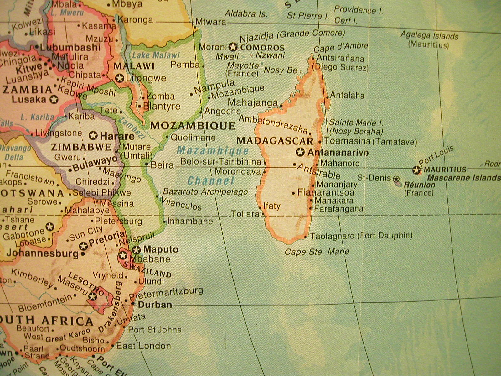
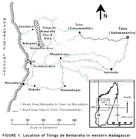
A location map of Madagascar |
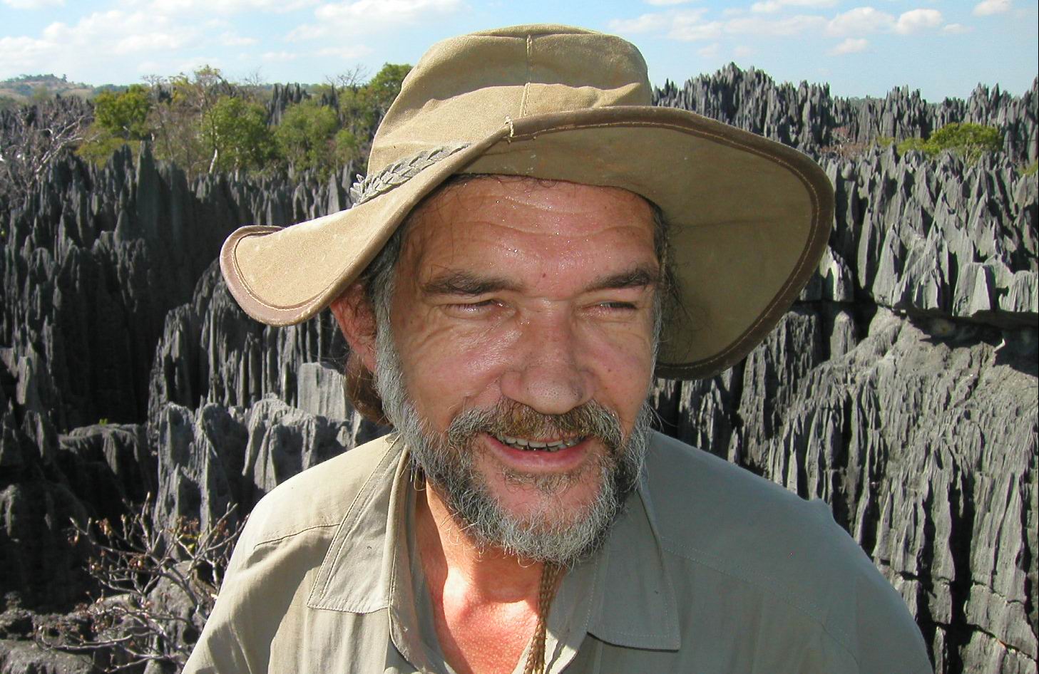
Arthur Clarke at Belvedere summit |
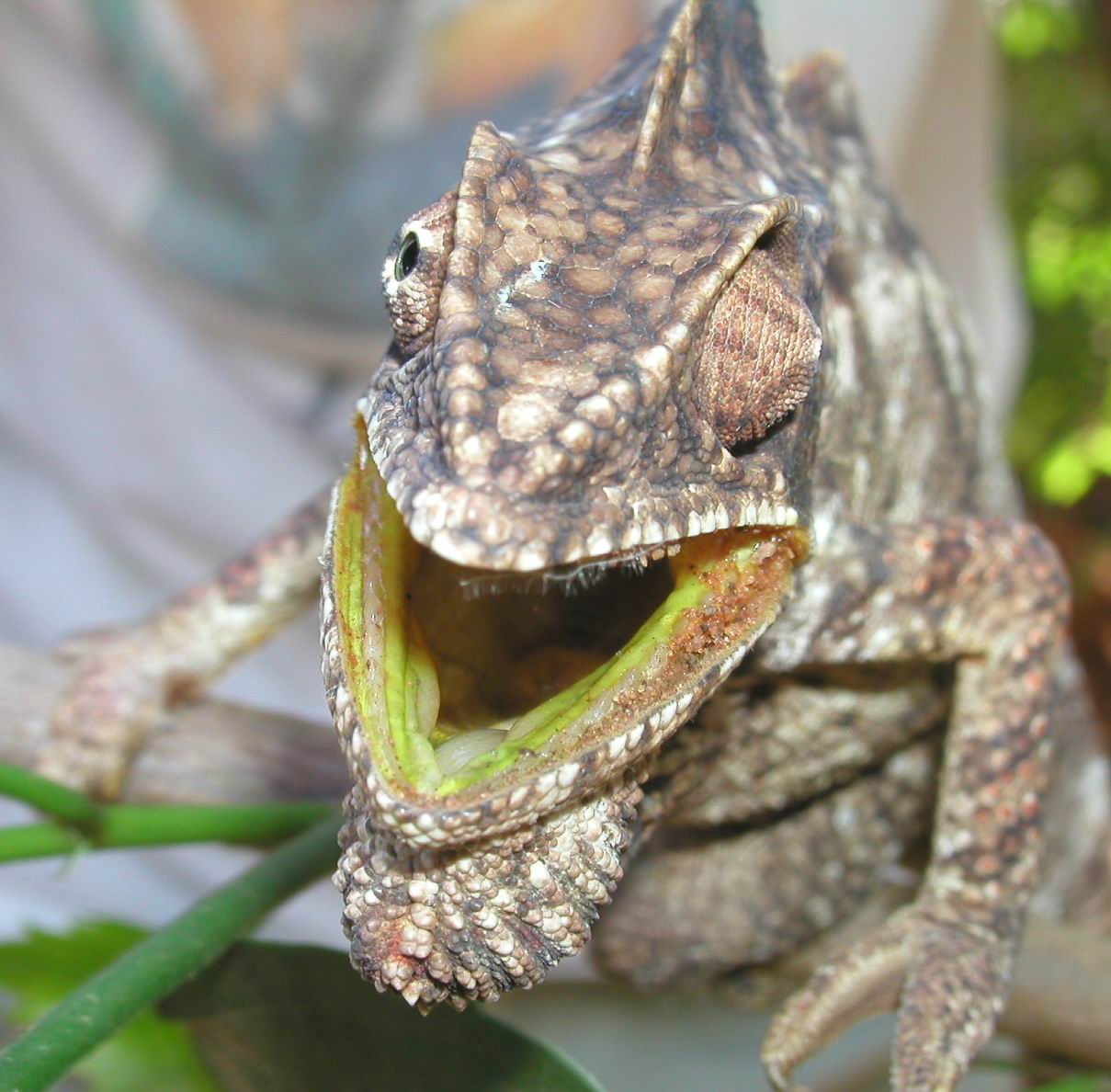
Head & face of chameleon (Furcifer oustaleti) |
Originally part of the African mainland and super continent of Gondwanaland, Madagascar is now an island country located 400km east of Mozambique (in Africa) and around 400km west of the small islands of Mauritius and Reunion. Situated between latitudes 12°S and 26°S, Madagascar is the fourth largest island of the world with a land surface area of 587,000 sq km; it is 1600km long and 570km wide and has a coastline in excess of 5000km. The central part of Madagascar consists of high grassland plateaus and hills with an elevation typically ranging from 600-1200 metres, but the highest mountain (Maromokotro: 2880m) is located in the northern part of the island. As shown in Figure 1, the Tsingy de Bemaraha is situated in central western Madagascar, around 18°S of the equator.
As discussed in more detail further on, Madagascar has a diverse culture with several ethnic groups related to the origins of early hominoid evolution and subsequent colonisation. The European influence dates back to around 1500, when the Portuguese named the island as São Lourenço and in subsequent centuries it became a base for pirates such as Captain Kidd. The first Christian Protestant missionaries arrived from England in 1820 and a treaty was established with the British allowing Madagascar to remain an independent state.
Sixty years later in the 1880s, Roman Catholic missionaries came from France and there was a massive conversion to Christianity, followed by a subsequent expedition of colonists in 1894 leading to Madagascar formally becoming a French colony in 1896. Although the country gained full independence in 1960 (following a civil war that began in 1947), the French influence and their language dominance is still very evident today.
Not surprisingly, the only direct long distance international flight into Madagascar is from Paris. You can also get flights from Reunion, Mauritius and the Seychelles, plus direct flights from Singapore and Johannesburg (in South Africa). Flying with Qantas from Sydney or Perth, the most direct (or indirect?) route to Madagascar goes via Johannesburg, where you stay overnight.
My flight from Sydney to Johannesburg took just over fourteen hours and is one of the longest non-stop flights in the world. Next morning, another flight from Jo-Burg and 3½ hours later ... I arrived at Antananarivo - the capital of Madagascar.
Antananarivo - capital of Madagascar
Many of the passengers arriving at Antananarivo did not have entry visas and simply went across to the booth inside the airport doors to get their passport endorsed. After getting out from airport - feeling like a stranger in a strange land - I was amazed at the crowd of 'welcoming' Malagasy people and the effort it took to exit the airport through a barrage of locals clamouring to assist me: luggage porters, money changers (offering 620,000 Malagasy francs for $100 US dollars) and street kid beggars - all wanting money, a tip or commission for their services (the word 'Malagasy' is used herein relate to the 'people of Madagascar' as well as being used varying as a descriptive noun or adjective describing their customs, monetary system and their language).
Situated in the central east of Madagascar, Antananarivo (better known to locals as 'Tana'), has an unknown population of several million people - no one could tell me how many people lived there! We travelled from the airport at a snail's space, held up by traffic jams on a Sunday afternoon: passing street side markets with slum housing backdrops, driving along narrow roads congested by cars, trucks, buses, cyclists, zebu carts, ponies and pedestrians... Where were they all going? From the outset you would have to say that Tana is an immensely crowded third world country city, where there are too many vehicles and not enough parking spaces!
 |
 |
 |
Jagged tsingy & kamenitza karren near IKOS site |
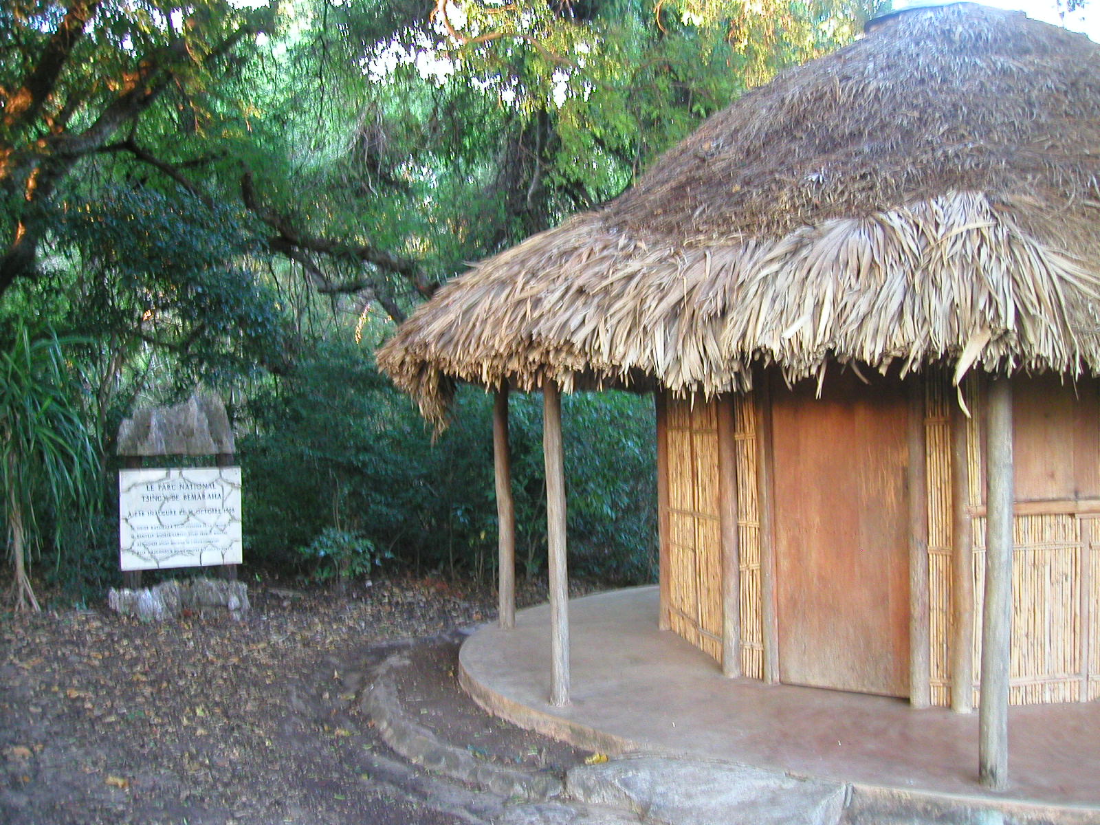
Tsingy de Bemaraha reception at Petits Tsingy |
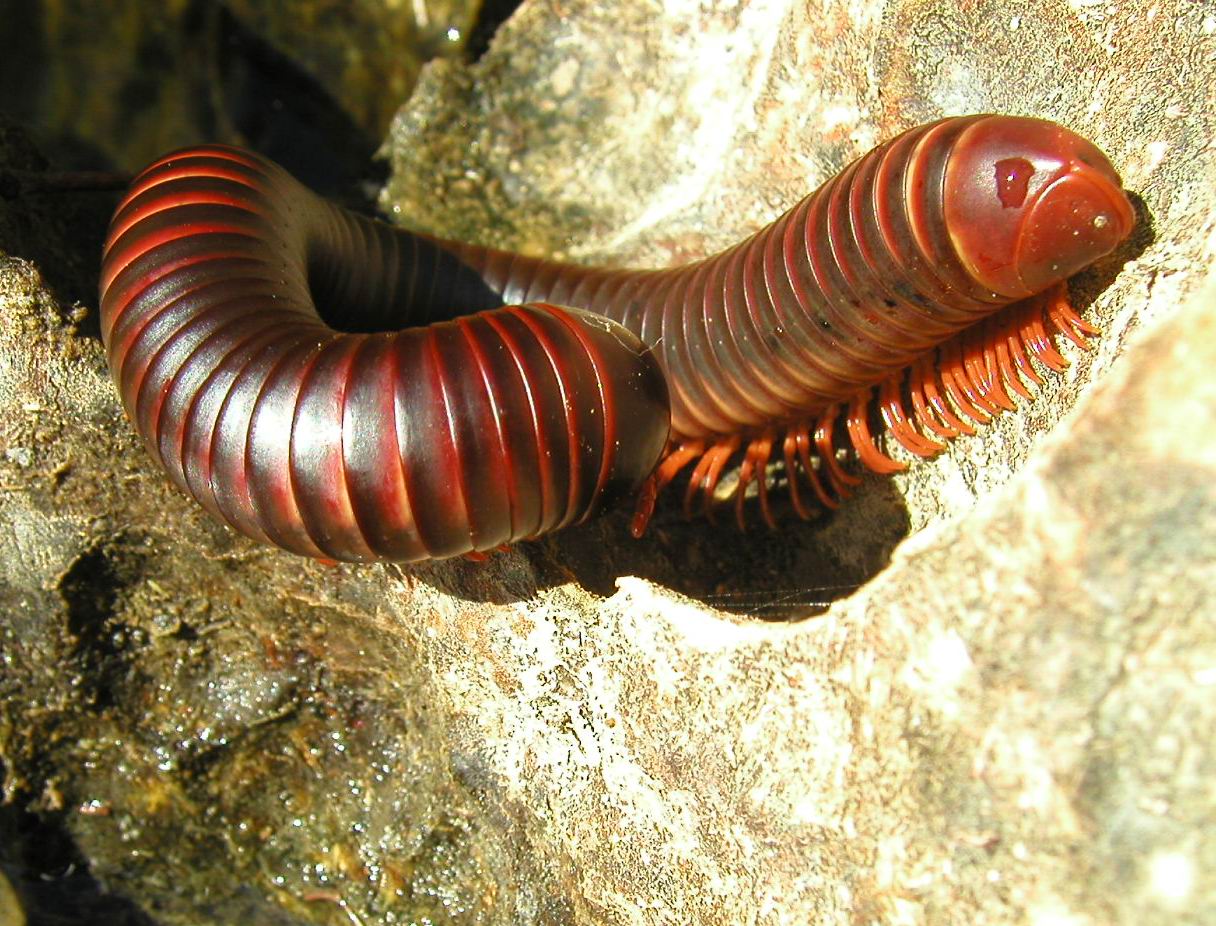
Large epigean millipede beside Dragon Fly Lake |
The sprawling urban centre and suburbs feature lots of narrow two-storey buildings with crumbling brick or mortar rendered walls and terracotta tile or rusted iron rooftops, often weighed down with rocks. I spent my first night in Madagascar at the Relais des Pistards (a hotel for backpackers or trekkers), situated opposite the Tsimbazaza Botanical Gardens and Lemur Park in the inner suburbs of Antananarivo. Experiencing my ever first tropical cyclone, the night sky was lit with brilliant lightning flashes, deafening thunderclaps, howling wind and absolutely torrential rain. Cyclones must be commonplace in Tana, because next morning when the storm had passed - leaving its legacy of fallen branches and a litter of leaves - it was business as usual with everyone out on the streets again. Florent Colney (the proprietor of the Relais des Pistards) was also anxious to get moving; he was the organiser/provedore for our filming expedition to the Tsingy de Bemaraha.
Getting to the Tsingy de Bemaraha Parc Nationale
Flying into Madagascar during early May 2003, before the end of the wet season, you could see swollen rivers and vast stretches of adjacent land inundated with reddish orange coloured floodwaters carrying massive amounts of topsoil or clay. The evidence of soil erosion was very obvious during our long drive west from Tana to Tsiroanomandidy - the first stage of our route to the Tsingy. (Many towns in Madagascar have very long names that are difficult to pronounce let alone to spell, so Tsiroanomandidy is now referred to as 'Tsiro'.)
Our five hour (240km) long journey to Tsiro took us along a sealed but winding and potholed road with numerous roadside washouts, passing sections of severely eroded de-afforested (now agricultural) land and numerous villages with mud brick or mud-walled grass roof houses. Our driver was a local expatriate Frenchman (who couldn't speak any English) and I was accompanied by Christian Holl (sound chaser and composer, producing the musical score for our film) and Francis Demange (a freelance photographer with three cameras taking photos for National Geographic magazine).
Tsiroanomandidy is an old town situated at the end of sealed road west of Tana, with French colonial architecture and ornately designed Catholic churches. Like most other towns in Madagascar, the streets were crowded with locals at street side stalls with the few vehicles dodging potholes, pedestrians and zebu carts. When we arrived in Tsiro, it was 42 degrees Celsius, giving us our first taste of the extreme heat of Madagascar. Sweat was pouring out of us when we sat down for a mid-afternoon lunch - zebu steaks and the local Malagasy 'Three Horses' beer... which has a really great flavour and is probably one of the best beers I have ever tasted. An hour or so later, we were aboard the only plane that day for the 140km flight from Tsiro to Bekopaka - a small village beside the Manambolo River in western Madagascar - used to access the southern reaches of the Tsingy de Bemaraha Parc Nationale, a World Heritage Area national park renowned for its magnificently eroded peaks of pinnacle karst. Seeing Francis with all his cameras and me with my digital, our English-speaking Swiss pilot gave us a photographic treat - a flight detour across some of the Grands Tsingy pinnacle karst, en route to our hill-top landing strip near Bekopaka. (The locals pronounce 'Bekopaka' as 'Bee KOO Puck' and as with many Malagasy town names, the accent is on the second syllable and you don't sound the last letter 'a'.)
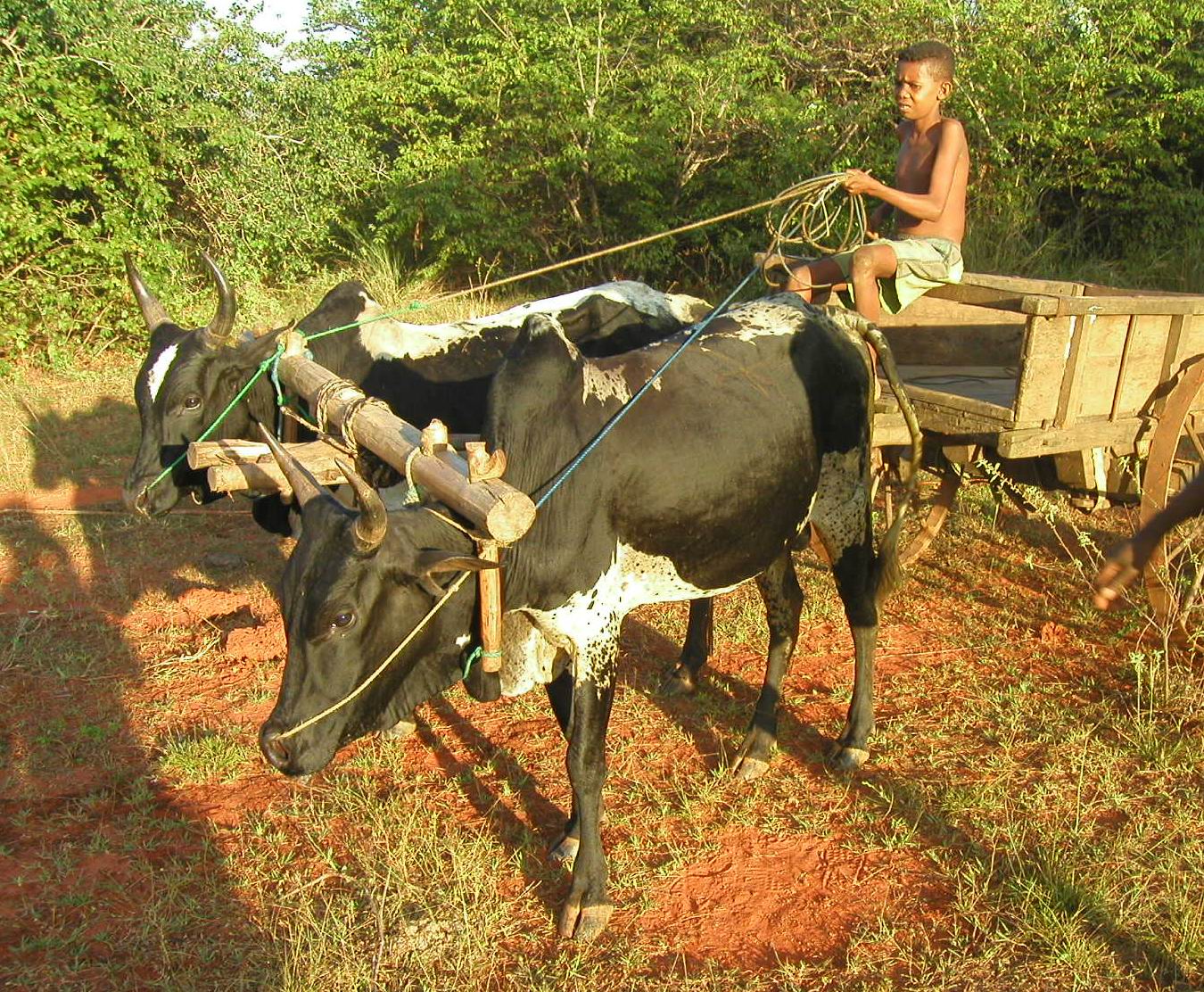
From our hilltop landing strip - a fairly rough, dry and crusty cracked earth surface amidst termite hills - the village of Bekopaka was another 4-5 km away. After our plane departed, we were left to ourselves, seemingly stranded ... wondering what happened next! Eventually, we heard the approaching sound of voices, cracking of a whip and thud of zebu (bullock) hooves towing a flimsy looking wooden cart. Referred to as 'chariots' by the French, these open-ended rickety wooden carts with sideboards have steel rimmed wheels and wooden axle hubs.
Our luggage was loaded on the cart with accompanying equipment, and then securely tied with ropes before we headed downhill towards the rapidly setting sun. The two zebus towing our cartload of luggage were driven by a small boy from the village, paid 25,000 Malagasy francs (Fmg) for his services, the equivalent of about six Australian dollars.
On our one-and-half hour walk to Bekopaka - accompanying the zebu cart - we were joined by two scantly clad Negroid tribesmen who appeared to be a father and son. Both men were only wearing waist-cloths and the older man carrying a spear also had a leather pouch hanging from his shoulder, containing just a plug of tobacco, a knife, pieces of paper (for rolling cigarettes) and an agate flint with metal striker, creating sparks to ignite dry tinder in a small cow horn.
After driving through the streets of Tana earlier in the day, then across the countryside to Tsiro and now further west to Bekopaka (arriving in the dark), it was apparent that many ethnic groups were represented in the population of Madagascar, with a predominance of Malay-Indonesian peoples in the east and Afro-Arabic people in the west.
An overview of the ethnology and cultural diversity of the Malagasy people
During our filming expedition in the Tsingy de Bemaraha, we were joined by a number of specialist scientists and consultants including Monsieur Ramilisonina - an ethno archaeologist from Tana, one of the very few participants who spoke good English. According to Ramilisonina, it is still unknown when early hominoid man arrived in Madagascar, but there is evidence that some of their culture still exists today due to inter-marriage between the later Vazimba people and some of the colonising groups that came from Asia and Africa.
Ethno-archaeologists describe the evolution of hominoids and development of cultural diversity in Madagascar in six different time zones - 1: Konka time; 2: Gola time; 3: Vazimba time from around 300-400 years BC to the 14th Century when there was subsequent 'inter-mingling'/inter-marriage with colonists; 4: Malagasy time from the 14th century onwards; 5: French time from the 1880s till 1960; and modern Malagasy time since independence. There were five different groups of people in different parts of Madagascar during the Vazimba time.
The first two groups were of short stature and had long hair covering their feet and body. These included the actual so-called Vazimba people living in the cooler elevated central plateau area around Antananarivo and the Kalanoro peoples who lived further east. The third group was the Kindoky, a race of tall people with long hair - described by Monsieur Ramilisonina as being a 'man-like animal' - which lived in the arid western Madagascar region including the tsingy limestone areas. A fourth group: the Kokolampo were also tall with long hair, but were confined to the far south and the last group. The Kimosy, also described as being tall, longhaired and having the appearance of a man-like animal lived in the southeastern parts of Madagascar.
Set against this backdrop of hominoid evolution within Madagascar, there has been five or six invasions of colonists from foreign lands! From the first century to fifth century AD, the first 'wave' of colonists sailed some 5000km by sea from Indonesia, followed by the next influx coming from what is now Malaysia in the 5th and 7th centuries; both groups colonising and inhabiting the eastern and central parts of Madagascar. From the 7th to 10th century, there was a migration of African peoples, mainly from the Mozambique area, settling in the western parts.
From the 9th and 10th centuries continuing into the 12th century, there were colonists from the Arabian Peninsula who predominantly settled in the north and in the 14th century there was a further migration from the Indian sub-continent.
The final group of colonists were from Europe, as explorers set sail in the 15th and 16th centuries to find fortune for themselves and their countries, leading to the French who arrived in the 1880s and 1890s, declaring Madagascar as a colony for France in 1896.
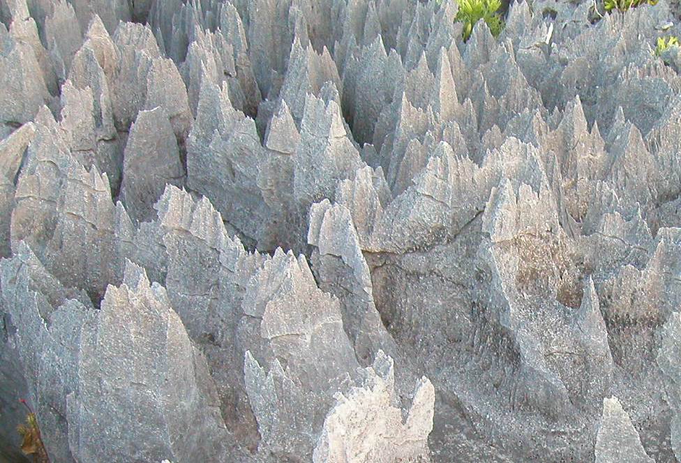
The Tsingy de Bemaraha of western Madagascar
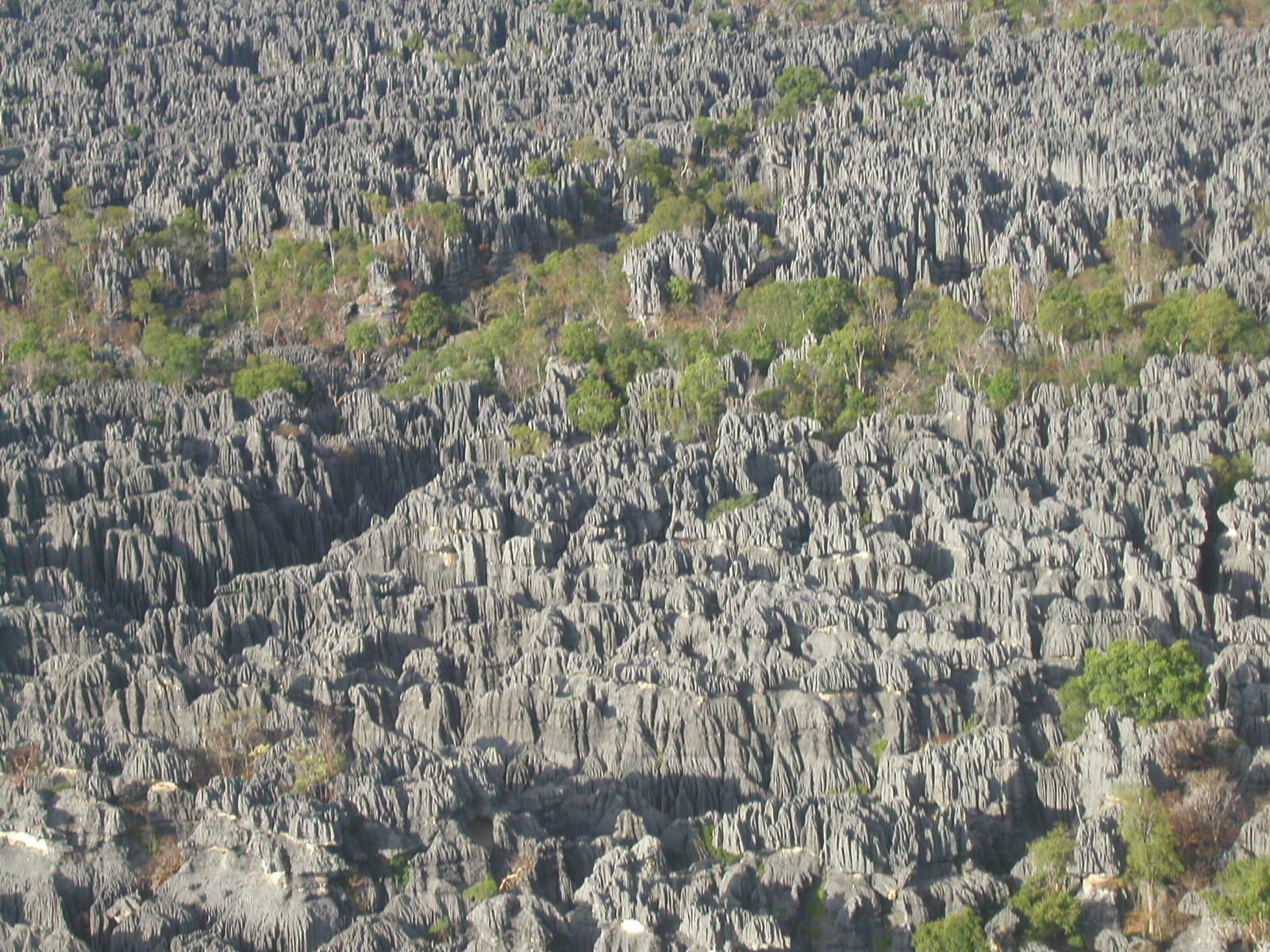
The Tsingy de Bemaraha Parc Nationale is one of two large areas of extensively eroded pinnacle karst located in the arid parts of Madagascar; Bemaraha is in the west and the other area, Ankarana (described by Greg Middleton in 1995), is in northern Madagascar. Although shown on maps as a continuous zone, the 152,000 hectare Tsingy de Bemaraha Parc essentially contains two separate areas of limestone: the low relief 'Petits Tsingy' adjacent to the Manambolo River (2.2km east of Bekopaka) and the more extensive higher relief 'Grands Tsingy' further north where limestone pinnacles are reportedly in excess of 100m high. Both areas are partially forested, with dense thickets forming in the canyons and fault grabens between elevated blocks of pinnacle karst.
The surface vegetation in the tsingy itself is quite unique with many endemic xerophytic and/or water storage plants. Although the tsingy receives torrential downpours in the wet season, very little water remains on the surface and in dry season, the only moisture for 6-7 months is the nightly dew so it is essentially an arid environment.
The 'arid' flora at Bemaraha typically includes cactiform succulents such as Euphorbia and Cynanchua, numerous bulbous stemmed plants or trees that hold water in their internal pith (e.g. Pachypodium, Adenia and the occasional baobab), the many thorned, narrow or spiny leafed xerophytic or xerophilous species (Pandanus and Dracaena) and the leafless plants such as Conniphora with photosynthesising trunks and branches. Surrounded by vast stretches of open savannah grassland, the Tsingy de Bemaraha bears a slight similarity to the sharply fluted outcrops of limestone in the Gregory National Park of The Northern Territory.
The word 'tsingy' means 'on the tip of the toes' in Malagasy, which is actually the way you have to walk on the rare flat spots between sharp points or on the thin near razor edge crests of the jagged karren flutes of the karst pinnacles or plateau regions.
 |
 |
 |
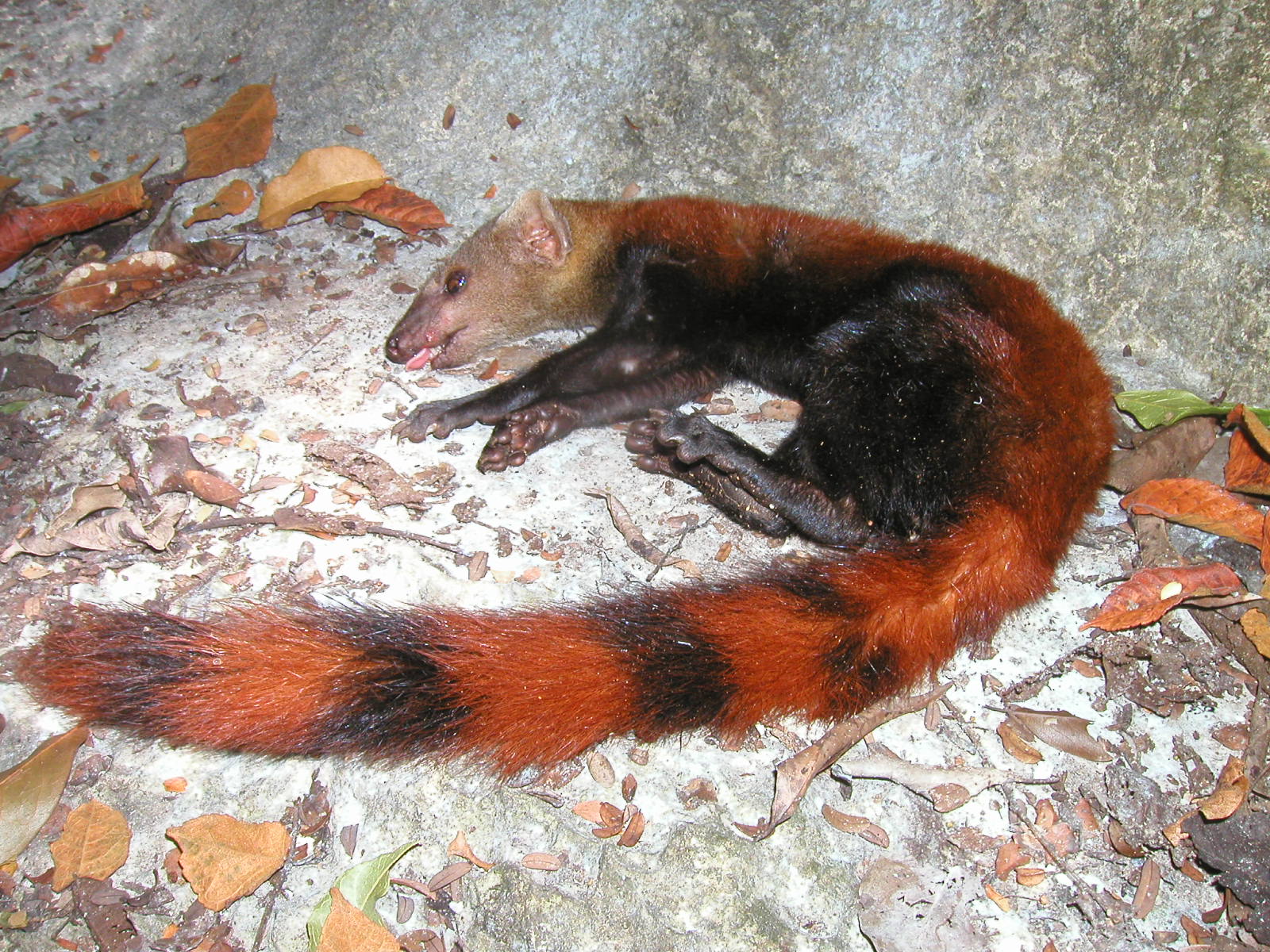
Sedated Malagasy mongoose on rock shelf |
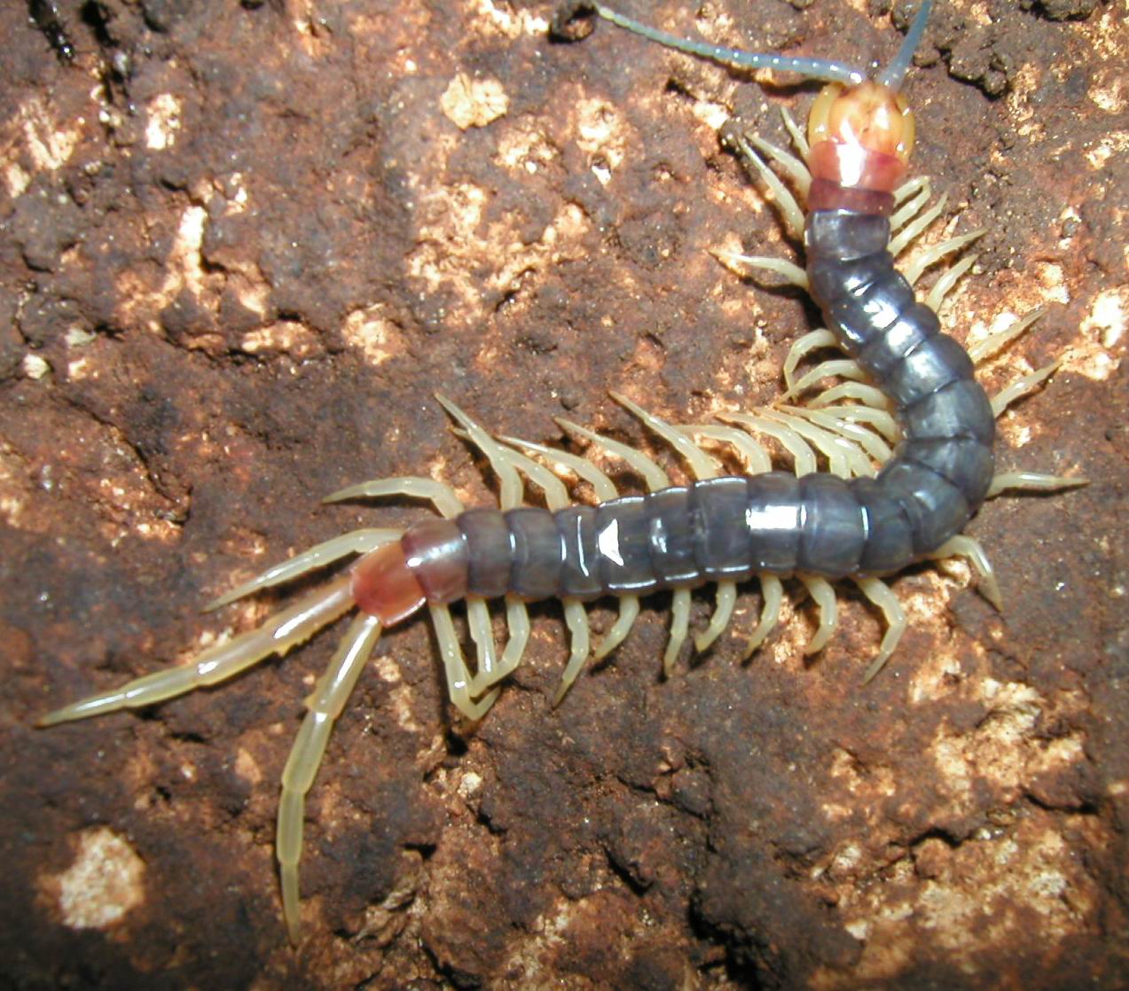
Scolopendron (Cave Centipede) |
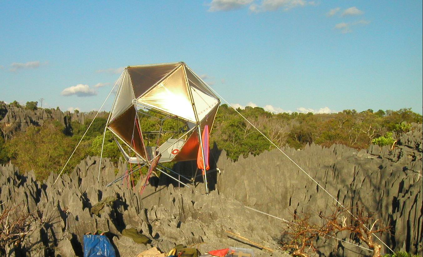
IKOS laboratory on top of Grands Tsingy |
However, there are many other meanings according to who translates this word to you. For example, I was also told that 'tsingy' is a Malagasy word for the sound that the flutes of this sharp edged abrasive limestone make when you walk over it. In fact it was perilously sharp with extremely thin, often barely 1mm thick flesh cutting razor-like edges on both the vertical karren flutes and the ridge crests themselves, so we had to clamber across the surface, with gloved hands often 'on all fours'.
In some of the few more plateau-like exposures of the Bemaraha Parc tsingy, you could occasionally avoid these sharp edges by stepping in kamenitza solution pans and smooth surface drainage channels. Although most Malagasy locals and Parc officials believe the tsingy's origin is due solely to the limestone purity, the heavy torrential wet season downpours and wind-driven cyclonic rains are likely to be a more major contributing influence to the development of this sharp-edged and abrasive tsingy karren.
Filming our documentary - in western Madagascar
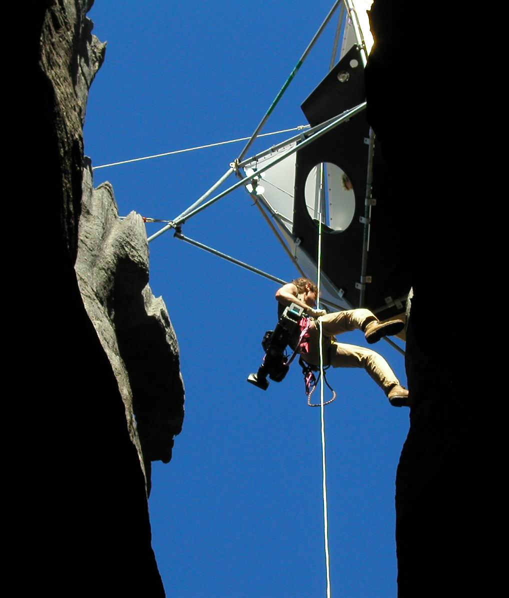
Titled 'Voyage au Centre de la Pier' (Journey to the Centre of the Stone), our documentary incorporated a number of pre-conceived concepts in production of the film. Some of these concepts were quite elaborate including having a cameraman (or two) in a motorised paraglider to film the tsingy limestone, its canyons and flora from the air. Another novel aspect of our documentary was our 'IKOS' - a specially designed, thermally insulated pre-fabricated globe-shaped geodesic structure that functioned as our field laboratory. Positioned at a relatively exposed site (in the Grands Tsingy) with supporting struts and guy ropes anchored into the limestone, it was suspended over a cave entrance (albeit a 35m deep grike). Three of us, our resident speleologist Jean-Claude Dobrilla (who works at Bemaraha Parc) and two scientists - a young herpetologist from Tana (Jasmin Randrianirina) and I as cave biologist - were filmed abseiling from the IKOS and prussiking back up. The IKOS was designed to depict us as scientists operating in the field, conducting various experiments on the solubility of the limestone and chemistry of its groundwater, as well as filming tsingy flora and fauna. The IKOS could accommodate up to four people at a time, sleeping in hammocks but it was very cold at night and a popular place for mosquitoes! In addition to our SRT activity, we were joined by expedition botanist (Jean-Jacques Delavaux) and filmed climbing the exposed limestone flutes and performing Tyrolean traverses on doubled ropes suspended between tsingy pinnacles across a 10-12m wide deep canyon with the 'Belvedere' (Tsingy de Bemaraha high point) as a backdrop.
Our film director's brief was twofold. Firstly, looking at the evolution of the species living in western Madagascar and more particularly in the Tsingy of Bemaraha, then secondly, to study the relationships /oppositions between two ecosystems at the same location - the hot and dry desiccating environment at the surface and the fresh or moist to humid, more constant temperature region in the cavernous depths below. Given that the Tsingy de Bemaraha has a unique array of endemic flora and fauna, there were many species of plants and animals that were on our hit-list as a 'must see'. As specialists in our respective fields, we were asked to sample, capture or locate sites where various noteworthy plants and animals could be seen and filmed in situ in caves, on the surface, in the surrounding forested karst or in either of the two especially prepared laboratories - in the IKOS or at the campsite filming laboratory. Some captured animals were sedated first to make them docile, so they could be filmed more easily before scampering off into the wild through the forest or across the tsingy limestone surface.
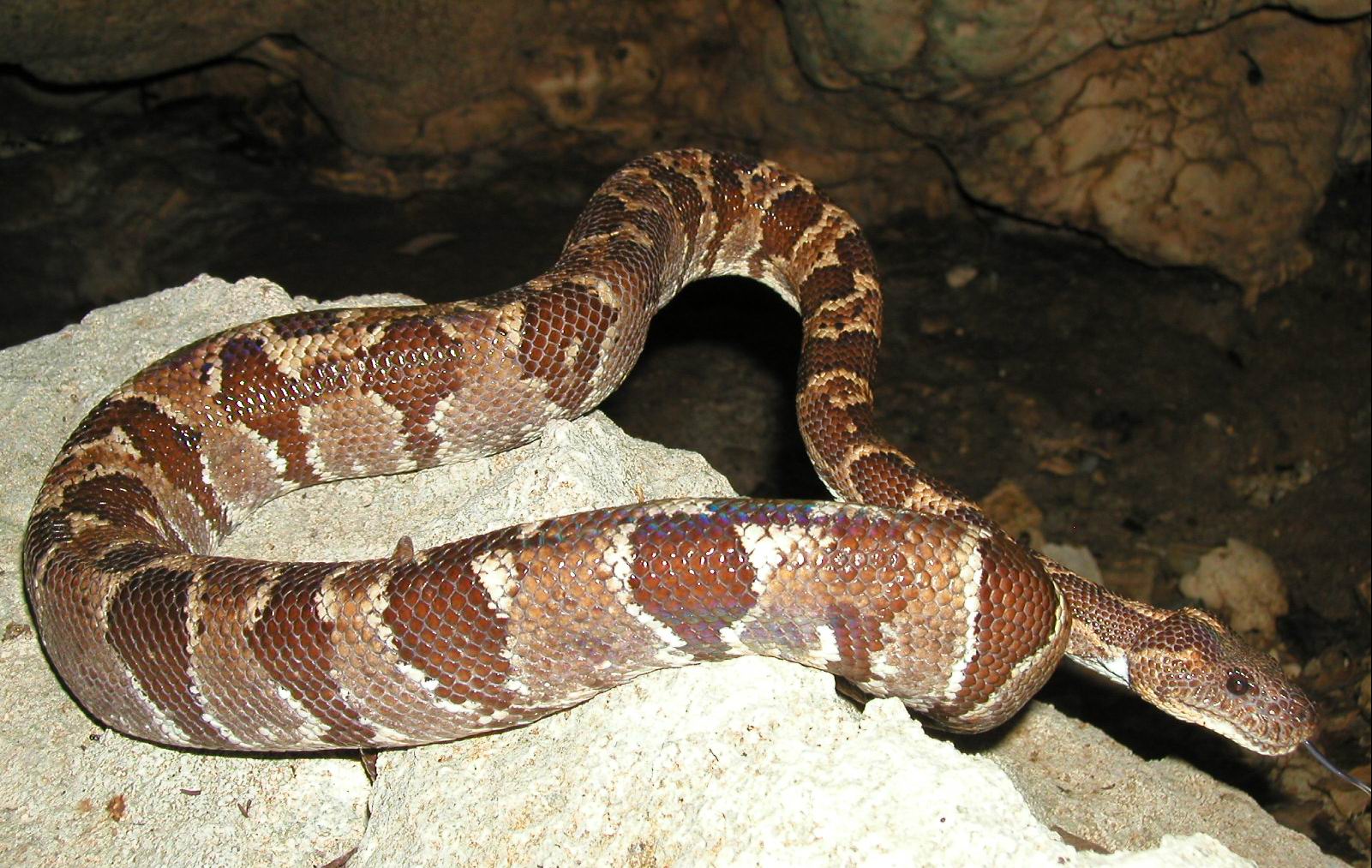
The first part of our documentary was filmed at the Petits Tsingy in the heat of the day, so it was a lot more pleasant when we found ourselves in a cave. Guided by Jean-Claude Dobrilla, the first cave we entered was Anjohy Manitsy (Cold Cave), but it took us three hours to get there, walking through humid forests, ducking under poisonous bean pods, avoiding wasp nests or the multi-coloured Nephila orb spiders in their tangly webs and clambering across tsingy limestone. This was the only dry cave we visited and it was the first (and only time) I was asked to handle snakes. While being filmed in Anjohy Manitsy, an aggressive male colubrid snake bit me and as blood spurted from my fingers, I became quite upset after just being (wrongly) told that the snake was venomous! For much of our remaining time at Bekopaka and in the Petits Tsingy, we experienced heavy rainstorms and spent time being filmed in our individually tailor made wet suits sitting on inflatable U-Boats. Filming occurred in several locations: the flooded canyons of the Circuit Touristique Tantely; amidst the calcite rafts in Anjohy Rana Manga (Blue Water Lake Cave); and on Angidina Farihy (Dragon Fly Lake) surrounded by sharp and abrasive tsingy limestone. This lake setting was quite picturesque, with lemurs gallivanting in the treetops beyond, but it was very uncomfortable, as the daytime temperature reached a scorching 44 degrees.
The wet season in Madagascar was still happening during the second week of May 2003. There was no ferry service for vehicles across the Manambolo River (you had to cross via dugout canoes), besides which most roads were impassable to anything other than zebu carts. Zebus seem to be everywhere in Madagascar. They are their equivalent of our beef cattle, with a conspicuous hump on their back like Brahmans, but their broad and erect horns make them appear more akin to what we would call bullocks or perhaps buffalos. So the only available transport north from Bekopaka to the Grands Tsingy (our next filming site) was via zebu carts, with twenty expeditioners and Malagasy helpers walking alongside.
Our Grands Tsingy base camp was located about 17km north of Bekopaka, situated in a forested graben canyon (down-faulted block) between 50-60m high massifs of tsingy pinnacle karst. Our tents were positioned on the flat forest floor each side of a small clear water stream running through the canyon under the tree canopy that was home to bands of chortling lemurs each night. On one side of this canyon, elevated above the forest floor, a semi-circular cave entrance overhang was converted to be our communal living area.
We had meals in a dining area complete with table and benches made of Malagasy mahogany; adjoining this was a food store area, kitchen with open fire and gas stove, an elaborate water filtering system, camp hardware equipment store, battery charging area and further along near the generator site: a filming laboratory.
This campsite filming area was quite elaborate with a large sheet of laminated seven-ply bolted on to limestone blocks to form a level table base complete with flexible optic fibre lights, microscopes, endoscopes and elaborate macroscopic filming devices with joystick control, telescopic and swivel mounts, various clamping devices, aquariums, terrariums, plus preview monitors, editing monitors and associated filming facilities. Beyond was the sound-muffled area where two petrol driven generators where housed besides another flat area where ducks, chooks (chicken) and turkeys lay in waiting (with their feet tied), feeding on kitchen scraps before going into the cook pot. We even had a pig on site and produced our very own bacon.
An overview of fauna and cave ecosystems in the Tsingy de Bemaraha
Amongst the four-legged animals that were caught in pre-baited cages or pitfall traps, we saw three types of mammals: the Ring-tailed Malagasy Mongoose (Galidia elegans occidentalis); a smooth-haired (mouse-sized) insectivore (Microgale sp.) and the rarely seen Malagasy fosa (Cryptoprocta ferox). Not to be confused with the Malagasy civet or Fanaloka (Fossa fossana), the Malagasy fosa is a brown-haired arboreal and ground-dwelling carnivore with a large cat-like body, but a dog-like face, long whiskers, long tail, short legs but long claws. In the tree canopies, we saw two types of lemurs: the black-faced, white-bodied Sifaka and the western avahi (Avahi occidentalis); and in old tree hollows we caught glimpses of the tiny nocturnal lemur (Lepilemur edwardsi).
Chameleons seemed to be everywhere with the endemic Brookesia perarmata and species of Calumna and Furcifer most prevalent, one of which we saw swimming in a lake. Lizards (e.g. Oplurus), various Mabuya skinks and geckos (the minature Lygodactylus and larger Phelsuma day geckos) were seen basking on limestone outcrops; various species of snakes (Boidae and Colubridae) were seen in the forest or in caves, where frogs (mantelids and ranids) were also common. A single turtle (Pelomedusa subrufa) was found near one of the very few perennial lakes. In a few of the tsingy caves we saw colonies of tiny insectivorous bats (microchiroptera) and a few giant fruit bats (megachiroptera) were filmed in the sheltered diaclase canyons. There were numerous invertebrates (too many to list here individually), but notable amongst these were the butterflies, spiders and scorpions seen both on the surface and in caves, plus the giant cockroaches, beetles and dragon flies found in the forest and tsingy.
From a brief overview of the very few caves actually visited in both the Petits Tsingy and Grands Tsingy, it appears that there were two main types of cave ecosystems at Bemaraha. Firstly, those where the dominant source of energy (or nutrient) was derived from organic matter falling from the surface, washed in by streams or associated with tree roots and secondly, those caves with colonies of bats and vast amounts of guano supporting a range of small guanophiles and larger invertebrates such as cave scorpions, spiders, centipedes and butterflies, plus a few frogs and quite large snakes: e.g. Boa madagascarensis. There were quite different species assemblages in both types of cave ecosystems with opilionids (harvestmen) and coleoptera (beetles) being amongst the dominant small macro-invertebrate species in the stream caves and pseudoscorpions as the dominant small species in the bat guano caves.
Archaeological finds in the Tsingy de Bemaraha
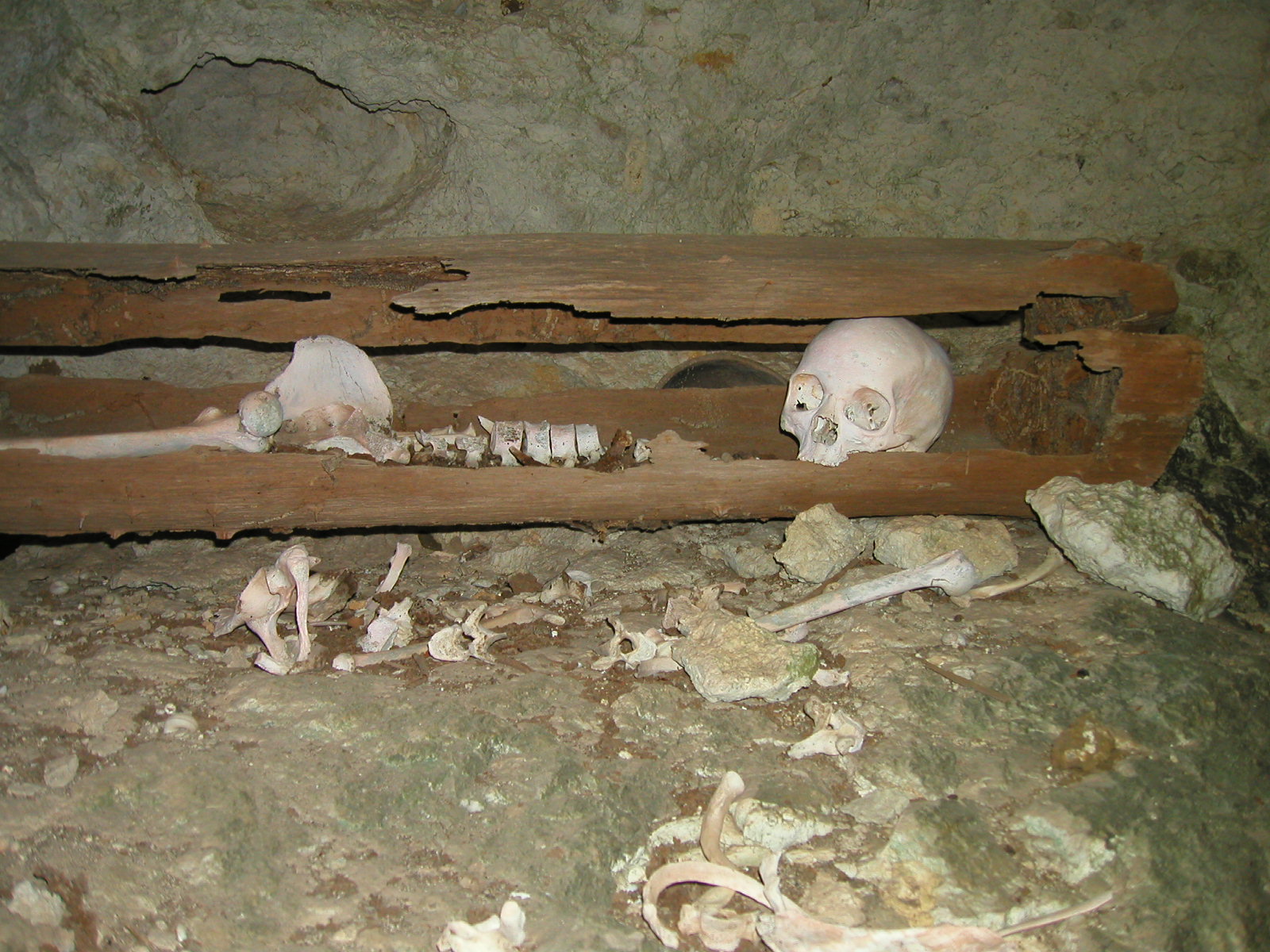
During the month long filming stint at Bemaraha, I was fortunate in being able to see and photograph a number of recent archaeological finds. Included amongst these was the gigantic 10-15 litre capacity egg of the extinct Malagasy elephant bird Aepyornis ('cousin' to the extinct New Zealand Moa); the sub-fossil remains of a 1000-2000 year old Archeolemur; and several cultural sites in cave entrances or overhangs where there were ancient fire hearths, cave wall paintings, raised bedding structures and a burial tomb site. All these cultural sites were located in elevated, dry and sheltered places, hence their remarkable state of preservation. Beside a cave entrance wall, partially blackened by the smoke of cooking fires eons ago, a series of pictograph 'paintings' depicted scenes and images of zebus; these appeared to have been drawn with a mixture of charcoal and animal fat. The bedding structures were made from forest tree poles lashed together with vines to form a frame on which slabs of bark were placed. The so-called 'Vazimba' tomb site was a new discovery and still remained in a fairly pristine or undisturbed state, although it was obvious that the skeletal remains had been scavenged by marauding animals.
I felt extremely privileged being invited to join the expedition archaeologist (Monsieur Ramilisonina) to visit the relatively inaccessible site with the Vazimba 'tombs' where bodies of Tsingy forest honey gatherers had been laid to rest. Ramilisonina estimated that the bodies were around 300-400 years old, based on factors related to the condition and surface staining of skeletal bones, plus associated artifacts including their honey pots, and the degree of decay (or rot) of the coffin wood. Some of the adult bodies - measuring 1.60m in length (height) - had been laid to rest in simple coffins made from two hollowed tree trunks placed under and over each body; other bodies (younger people) were simply wrapped in sticks or vines supported by slabs of limestone. With honey pots beside their heads (skulls), the adults had been laid to rest face up with their bodies generally positioned in an east-west orientation (although this E-W orientation is the norm, I was advised that the first priority for a burial place was the site suitability, so the orientation of bodies is more dependent on the cave morphology).
There were distinct differences in the shape of adult male and female coffins. Apart from the difference in coffin shape, one adult was obviously a woman: she had been laid to rest with a copper bracelet still on her wrist, a necklace made of small teeth and the bodies of three small (infant) children beside her, including one that was probably a baby. Adolescent children had been laid to rest (without honey pots) in separate tombs, with their heads on their side (facing north) and a rock lying against their skull to simulate lying against a pillow.
Archaeological evidence points to the fact that the early Vazimba people who occupied central Madagascar did not have the knowledge or ability to cut rock or carve wood to make coffins. Because it is known that the Vazimba inhabited the interior regions, there is the perception that these relatively isolated tomb sites are very ancient Vazimba 'burials'.
Although still incorrectly referred to as belonging to the Vazimba people, there is a some growing awareness in the villages neighbouring these 'tomb' sites (e.g. Bekopaka), that the human remains in the burial sites are probably the ancestors of modern Malagasy people from that same general area - being villagers who simply went 'bush' to escape life in the villages for whatever reason - possibly due to disputes with other villagers or to escape the wrath of feudal village chiefs or village bosses.
Karst management in the Tsingy
Although accessible parts of the Tsingy de Bemaraha national park are now being developed for eco-tourism, it's extremely unlikely that these previously mentioned archaeological sites would be open to tourists. However, there is a burial site with many more tombs (Middleton, 1996) that can be viewed from a distance, as you sit in a dugout canoe on the Manambolo River on one of the organised tours conducted by the Bemaraha Park guides. Listed as the Manambolo River gorge trip, this five hour long trip takes you via dugout canoe going upstream from the Bemaraha Park program reception office, with a visit to two of the river side caves described in Greg Middleton's 1996 report, then a return walk overland through some of the Petits Tsingy pinnacle karst and across a kamenitza limestone plateau. Prior to partaking in any of their river excursions or tsingy walks, Bemaraha park officials or guides provide all tourists with a set of guidelines that are strictly enforced in order to minimise impacts and help preserve this unique natural area.
Though poorly funded and often not yet adequately researched, some of the more natural areas in Madagascar are now protected by a system of national parks and reserves, though from an outsider's point of view, their management appears to be ad hoc. Declared as 'World Patrimonium to Humanity' by UNESCO, Le Parc National Tsingy de Bemaraha was formally made a national park on 16 October 1998. As the largest protected area in Madagascar, it is managed by ANGAP (Association Nationale pour la Gestion des Aires Protégées). Translating as the National Association for the Management of Protected Areas, ANGAP is an autonomous (non-governmental) Malagasy organisation established to administer the parks and reserves in Madagascar.
At Bemaraha, the management process involves two structures. Firstly, the ANGAP administration centre maintains jurisdiction across the whole 152,000 hectare area (with its head office in Antsalova and subsidiary office at Bekopaka). It is responsible for the development, maintenance and research activities in the park, including establishment of access tracks or associated infrastructure and issue of permits for projects such as our documentary.
Secondly, there is the ANGAP Parc Program - essentially the commercial side of management - providing park entry tickets, guides and interpretation services. I just happened to be in Bekopaka when ANGAP officials were pronouncing the 'Manifestation of the Tsingy' as part of the celebrations for International Day of the Environment on 5 June 2003. With support from local schoolteachers, the ANGAP Director for Bemaraha addressed school children and villagers in the concrete football stadium adjacent to their gravel surfaced soccer ground, stressing the need to protect and conserve the tsingy, which is being opened up for tourism.
Both the Petits Tsingy and Grands Tsingy are being developed for tourism, for trekkers or day walks, with tracks being positioned along strategic routes to minimise impact, including protection of tsingy flutes and karren edges. Large slabs or shaped pieces of limestone are bolted on to rock faces for use as steps up the side of karst pinnacles to access lookouts.
The Reception office for the Tsingy de Bemaraha Parc is located just inside the park boundary (about 2.3km east of Bekopaka) on the north side of the Manambolo River, near where the ferry carrying road vehicles crosses the river. Apart from flying into Bekopaka, the main access to the Bemaraha Parc is from Morondava, 220km SSW (a seaside resort on the west coast of Madagascar); you travel north via Belo - a 4WD journey all the way. Entry to the Bemaraha Park costs 50,000 Fmg - equivalent to $13.30 AUD - and your receipted 'ticket' is valid for three days. For the Manambolo River gorge trip, the two dugout canoes (one for me and one for the guide) cost another 20,000 Fmg ($5.30) that includes canoe hire and payment for the canoe man. You then pay another 30,000 Fmg ($8.00) for your English-speaking Malagasy guide. Monsieur Andrianirina Lala (Chief Technical Officer for Interpretation) told me that almost 99% of visitors speak French, but as part of their training, park guides are required to learn at least one other foreign language and the guide that I had been given was their best English speaker.
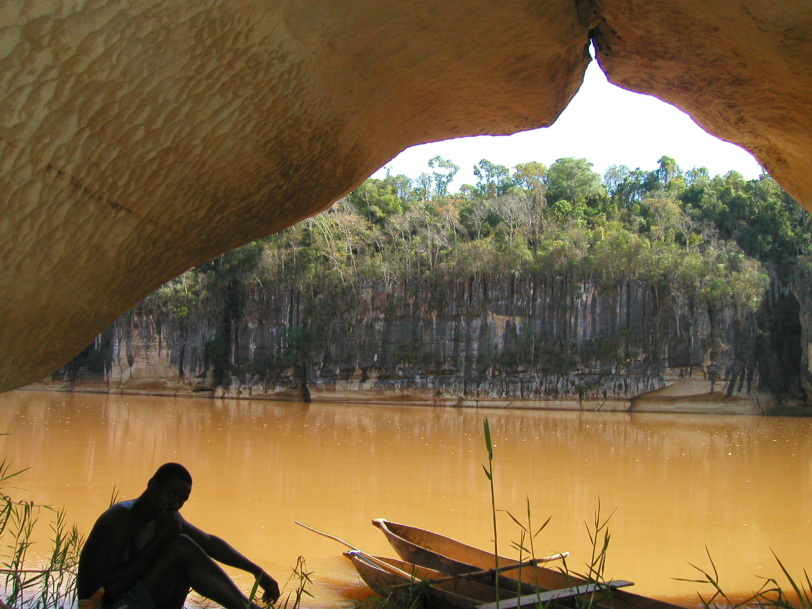
The guides have to wait all day at Parc reception, on the off chance that a punter (tourist) comes along, but then only get paid once a month for the guiding trips they are allocated. My guide told me that at this time of year (early June) they might only get two or three guiding trips per fortnight. Once aboard our two lakas (dugout canoes) - both loosely tied together to give added stability - the guide detailed all the park rules, many of which were commonsense or designed to help maintain the near pristine state of the area. However, first and foremost amongst the rules, it was fady (taboo) to use your finger to point; you had to use the knuckle of your forefinger! Our canoe man was initially paddling, and then poling as we progressed upstream into the fast flowing, shallower waters of the Manambolo River where the sculptured white cliffs of limestone were a marked contrast to the tan-orange coloured river waters.
 |
 |
 |
Arrival of zebu cart at Bekopaka airport |
Adult remains in a hollow log coffin |
Boa madagascarensis waiting for bats |
During my time at Bekopaka, I had discussions with the ANGAP Chief Conservatoire/Botanist for Bemaraha (Monsieur Ravelomanantsoa Herilala), providing a detailed written explanation for the formation of karst and reasons for the development of the tsingy: the limestone chemistry and physical properties; limestone structure (bedding and tectonic alteration); the roles of soil cover, vegetation and solution processes; plus the significant effect of past and present climate, particularly rainfall. After describing aspects of the cave ecosystems in the Bemaraha Parc and the species diversity therein, Mr. Herilala expressed a keen interest for me to return in mid-April next year to do a more comprehensive cave fauna inventory.
Although it will be possibly a good time for some cave animals, with the problems of access due to wet season (high stream levels and inaccessible roads), I am not convinced that it will be the best time, especially since it will be very hot and humid. However, the weather may be less intense further north - in the Berano area southeast of Antsalova, where there are better access roads and some larger more ventilated cave systems. I have also been tentatively invited to join a speleological/archaeological expedition around September 2004.
Unless you are tenting at the campgrounds under giant mango trees beside the Manambolo River, there are basically just two hotel accommodation options for tourists who arrive at Bekopaka. Both hotels are owned and run by the same person: Monsieur Decampe Choupa, who also manages two resort hotels in other parts of Madagascar. During our stay, we were based at the more primitive Auberge des Tsingy de Bemaraha, housed in poorly ventilated bungalows where the outdoor communal shower room was just a bucket of cold water with a small bowl to splash you. Marketed for budget travellers and backpackers, two person bungalows cost 45,000 Fmg ($11.90) and single (double bed) bungalows are 40,000 Fmg. When we first arrived there was no power and just one single communal squat toilet. The more modern up market Relais des Tsingy - built on a hilltop overlooking the Petits Tsingy and Manambolo River - has more modern spacious bungalows, showers, flush toilets and a modern grass thatched roof open-sided restaurant with satellite television and choice of wines. Bungalows are 150,000 Fmg for singles and 250,000 Fmg ($66.00 AUD) for doubles.
Concluding remarks and comments about Madagascar
Staying at a hotel anywhere in Madagascar was quite luxurious compared to the primitive conditions experienced at our campsite in the Grands Tsingy, where we had limited food resources and very basic amenities. Most expeditioners suffered some sort of stomach upset and towards the end of our stay, the creek that supplied our drinking water (before purification) stopped flowing. One of the major concerns for us in the food department was the distinct lack of vegetables (greens and root vegies), plus very little fruit apart from occasional bananas and papaya (paw-paw). Most Malagasy villagers are very poor and don't eat well; like us at our campsite, their staple diet appeared to be rice or noodles and meat, sometimes supplemented with Malagasy potatoes. I saw more poverty and deprived living conditions in western Madagascar than in all the more distantly remote parts of southwest China.
Towards the end of our time in western Madagascar, we were well and truly in the grips of sub-tropical winter ... the dry season, where many trees are losing their leaves, creeks start to stop flowing, roads and tracks revert to being initially muddy quagmires then hoof-holed, ankle-twisting hard crusty surfaces. Despite also being in the southern hemisphere, it takes a bit of time to get used to daily temperatures that average between 35 and 40 degrees C. The evenings get surprisingly chilly with heavy dew and on my way back to Tana, travelling in a cramped overnight taxi-brousse from the seaside resort of Morondava, I actually experienced a frost in the elevated central plateau region around 2.30am.
 |
 |
 |
Manambolo River view from Anjohy Mboro entrance |
Tsingy de Bemaraha overview |
Film director (Nicholas) descending from IKOS (with camera) |
There were two mishaps for me in Madagascar. Both happened on my return to 'civilisation' in Tana. Firstly, I was 'mugged' by street kids who stole some small money from my pockets, then later on the same evening had my wallet stolen while having a few beers in an up market bar in Tana. Having lost all my credit cards and money (after just cashing in my travellers cheques), I was in a real predicament and only just got out of Madagascar after being let off paying my hotel bill and getting an emergency flight back to Johannesburg. I would have liked to think that my money and valuables went to some one who was poor and needy, but I suspect professional thieves took it. The second mishap was more minor. I discovered that sending postcards from Madagascar is an occupational hazard for the intended recipient. If you were expecting a card and didn't get one, I apologise. If you did get a card, then you were lucky. I put a dozen postcards in the mail, but only know of one person who received one. It has since been pointed out to me that Malagasy postal officials are renowned for souveniring postcards from the mail sort, selecting attractive images to adorn the lounge or bedroom walls of their homes!
Despite its drawbacks - poor communication and transport infrastructure and the abject poverty - it has one of the most interesting and diverse cultures amongst the third world developing countries. There is also a diversity of biogeographical zones with a range of vegetation types and ecosystems from coastal to alpine and sub-tropical arid savannah or desert to lush tropical rainforest. Although there are vast areas of severely eroded landscape, there are also pockets of near pristine wilderness - some in quite remote areas (such as the Tsingy de Bemaraha) - most of which now lie in protected reserves and national parks or other partially protected regions.
REFERENCES
Clarke, A. (2003): The Tsingy de Bemaraha pinnacle karst of western Madagascar. Australian Caver #159: 4-12.
Middleton, G. (1995): The great Australo-Malagasy Speleo-Malacological Expedition, Ankàrana - 1994. Jnl. Syd. Speleo. Soc. 39 (4): 67-78.
Middleton, G. (1996): The 1995 Australo-Anglo-Malagasy Speleo-Ornitho-Malacological Expedition, Tsingy de Bemaraha, Western Madagascar. Jnl. Syd. Speleo. Soc. 40 (9): 141-158.