The broad Lune River valley of far southern Tasmania is surely one of the most geologically and geomorphologically fascinating places in Tasmania. The northern slopes of the valley boast Precambrian dolomite deposits which host the Hastings karst, including one of Tasmania's most popular show caves, Newdegate Cave in the Hastings Caves Reserve.
On the southern side of the valley Ordovician-age Gordon Limestone at Marble Hill is riddled with the rather large set of holes known as Exit Cave. With its spacious and lengthy passages, delicate speleothems, pyritic palaeokarst deposits representing multiple periods of ancient cave development stretching back to Devonian times, evidence of phases of sulphuric acid, hydrothermal and glacially-influenced cave development, sub-fossil megafauna bones and endemic cave fauna, Exit Cave is with good reason a part of the Tasmanian Wilderness World Heritage Area.
But the geological and geomorphic interest of the Lune Valley doesn't stop there; it also boasts several of Tasmania's few warm karst springs, Tasmania's only significant deposits of Jurassic-age basalts and sediments in a narrow fault slice, which host one of Tasmania's richest known agate and chalcedony gem fields together with abundant silicified fern and tree fossils that include outstanding features such as a 17 metre long intact tree trunk.
Then there's Pleistocene glacial deposits extending to unusually low altitudes for Tasmania, probable uplifted marine terraces, and - on the very summit of Coal Hill - some very strange unconsolidated boulder deposits of dolerite and mudstone which can only have come from somewhere above the present landscape. Which is to say, they are likely to be an isolated residual valley deposit of Tertiary or older age, now clinging precariously to existence on the highest point in the present day landscape.
All this geodiversity within an area of a few tens of square kilometres, criss-crossed by roads and visited by tens of thousands of tourists, cavers and gem-hunters every year, would surely be a magnet for geologists and geomorphologists keen to unravel its complex geological story, wouldn't you say? Wrong. Geologically, the Lune Valley is one of the most poorly mapped areas close to roads anywhere in Tasmania.
It has never been systematically mapped by the Tasmanian Geological Survey, or anyone else for that matter.
Just how poorly the geology is known is highlighted by the fact that the most reliable published geological mapping available for the area is the Geological Survey of Tasmania 1:250,000 scale Geological Atlas, which for the Lune Valley part of the map is based on a reconnaissance geological map provided by Sharples (1994). As it happens I have it on excellent authority that the map provided by Sharples (1994) is nothing but a compilation of a handful of scattered previous observations by others and some outcrops noted by Sharples, all stitched together with a lot of assumptions and wishful thinking....err, I mean, geological interpretation!
Just being one of the most geologically fascinating - and yet accessible - parts of Tasmania has never really been a good enough reason for the Geological Survey to spend money systematically mapping the Lune region. For that, you need the promise of money rocks of interest to the mineral exploration industry, and that's one thing the Lune Valley has precious little of.
 |
 |
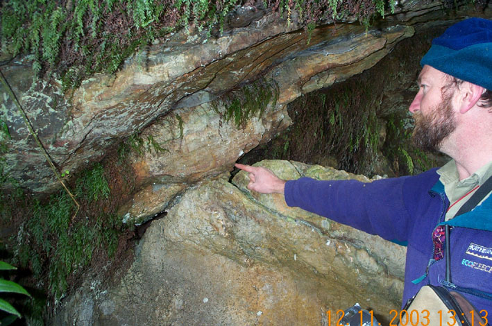 |
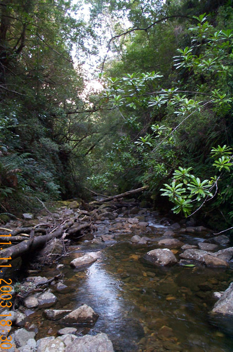
Figure 1: The vertical-sided gorge of Hot Springs Creek, upstream of Newdegate Cave, has been cut through an ancient terminal moraine complex. Glacial and periglacial processes have played a significant role in controlling the spatial pattern of karst development at Hastings. |
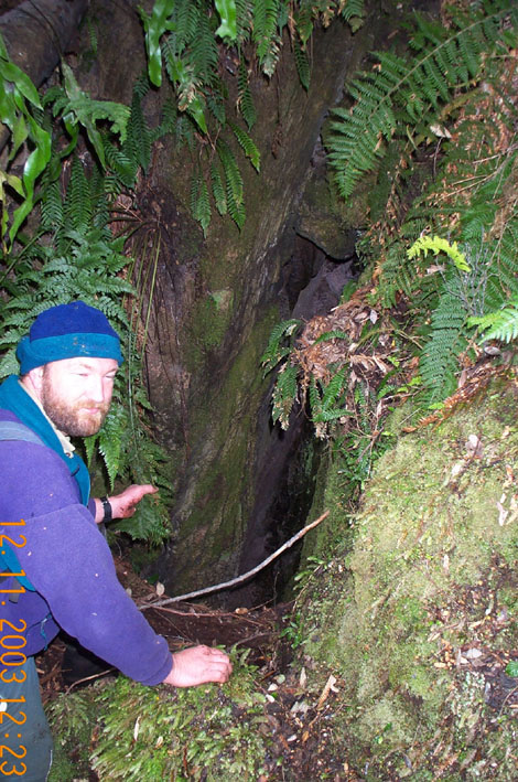
Figure 2: Ian Houshold not looking into a newly discovered vertical shaft in dolomite about a kilometre north-west of Newdegate Cave. A large stream could be heard flowing at least 15 metres down this shaft, and a large spring emerges from the valley side about 150 metres away and downhill. |
Figure 3: Ian Houshold points at the contact between dolomite and an overlying siliceous laminated sediment interpreted as a possible palaeokarst fill, on the northeast slopes of upper Hot Springs Creek to the northwest of Newdegate Cave. The laminated sediment may have been deposited on or in a karst feature that could be as old as Devonian age. |
As a result, we have the odd situation that Exit Cave, a listed World Heritage karst system of huge size and considerable geoconservation value, lies in an area of Ordovician limestone whose (probably quite close) physical boundaries are unknown.
Well, the unconformity surface on Marble Hill directly above the cave is fairly well known, and the faulted eastern boundary of the limestone can be reasonably inferred. But where is the northern boundary of the limestone? Does the limestone extend south of Exit Cave beneath the D'Entrecasteaux Plains to the flanks of Mt Leillateah? How far west does the limestone extend along the steep southern flanks of Moonlight Ridge, immediately west of Exit Cave? Sharples (1994) hazarded a guess, based on assumptions about topography, but the fact is that nobody really has a clue. And has more karst developed in limestones along those hill flanks? If you were to walk only a kilometre or less west of the well-travelled cavers tracks on Marble Hill, you could be the first to know!
Which brings me to the Hastings Karst, on the north side of the Lune Valley. Despite Newdegate Cave having been one of Tasmania's most popular and well-trodden show caves for the best part of a century, the boundaries of that dolomite karst have remained similarly unknown, except for a short stretch of the unconformity on Hastings Ridge above Newdegate Cave, whose position has for some years been roughly known in the area from the Wolfhole doline to the hill flanks above Newdegate Cave.
Yet, despite anecdotal reports - dating back roughly a century - of dolomite caves on the north side of Hastings Ridge, barely a kilometre northeast of Newdegate Cave and only about 200 metres downhill from the popular Adamson's Falls walking track, the extent and boundaries of dolomite on that side of the ridge has remained steadfastly in the realm of speculation. As has the degree of karst and cave development.
Worse, on the southern side of Hastings Ridge, just a short step up the valley from Newdegate Cave, the extent and boundaries of dolomite in the Hot Springs Creek valley were only guessed at by Sharples (1994) - and thus by the published 1:250,000 Geological Survey mapping. Based on extrapolation of the known boundary adjacent Newdegate Cave, it seemed likely that the dolomite could extend at least two kilometres further up Hot Springs Creek valley to the northwest of Newdegate Cave.
However despite one or two rumours which could not be substantiated with actual information, absolutely no geological observations or reports of caves and karst could be found for any location further upstream than the Newdegate Cave car park (I exaggerate, but only by a few metres).
One could of course regard this situation with pleasure, and in many respects I do. Its nice to know that plenty of little places remain almost literally unexplored, even places less than half an hour's walk from a major show cave.
Its comforting to contemplate how easily people can become focussed on one or two well-known features, to the extent that they will leave surrounding areas almost entirely mysterious and undisturbed.
And its interesting to note how easily people can spend years spinning yarns about legendary rumours of "caverns measureless to man" that somebody reported somewhere less than an hours walk from a road, yet nobody has got around to actually attempting to relocate them.
I'm not complaining of course. I originally drew some speculative boundaries on the Hastings Dolomite as long ago as 1979 (Sharples 1979), but I had never set foot much further up the Hot Springs Creek valley than the car park either, until November 2003.
Then, for reasons relating partly to a desperate need to get away from the computer and partly to the desirability of better information upon which to base a Management Plan, I teamed up with Ian Houshold on a quest to do something about finally sorting out the extent of dolomite, and assessing the likelihood of significant karst, in the upper Hot Springs Creek valley above Newdegate Cave. Ian of course should require no introduction - a household name in ACKMA circles I'm sure. (Ha ha Ian, I suppose you get people making jokes about your name all the time, eh? What do you mean it never occurred to you before!)
I won't bore you with details (or do I really mean, I'm not ready to reveal them yet?). Ian had previously made a brief excursion up Hot Springs Creek, during which he had noted several springs, cave entrances and a possible moraine (glacial deposit).
In order to revisit these and extend exploration further, we spent three days camping at an idyllic spot a kilometre upstream of Newdegate Cave, and stumbling around the valley sides looking at the ground with GPS in hand and satellite phone in pack. Wouldn't do to get lost, after all, and Occupational Health & Safety regulations say Ian's not allowed out in the bush without a sat phone connecting him to the global communication network.
It seems like only a little while ago that I used to regularly go out in the bush alone without telling anyone, sans GPS, sans radio, EPIRB or sat phone. Those were the good old days, sigh.
Despite a surface mantle of fairly extensive unconsolidated slope deposits in the upper part of the valley, we succeeded in convincingly nailing down the position of the unconformity (upper boundary) of the dolomite on the north-west and north-east valley sides.
Interestingly, we found the unconformity to be quite irregular in parts, with notable low points where we found hard siliceous laminated and brecciated sediments overlying the dolomite and underlying the Permo-Carboniferous marine sedimentary cap-rocks.
We've tentatively interpreted these as palaeo-karst sediments, potentially laid down on or in a karst environment (a big doline?) that could conceivably be as old as Devonian (circa 380 million years ago).
The primary interest of course was the present day karst. Yes, we found plenty. A big subjacent collapse doline, numerous smaller dolines and stream sinks, and at least 4 vertical cave entrances were noted in a single pass through one particularly interesting area barely more than a kilometre from Newdegate Cave.
Perhaps the most interesting was a vertical shaft of unknown depth, in which a large stream could be heard flowing. We also found a big spring disgorging from the slope about 150 metres away and downhill. There exists a need to return with a length of mum's old clothes line and go down that shaft for a look!
None of these features had been reported or recorded previously, however it is evident that a significant degree of karst development is present in the dolomite well up-valley from Newdegate Cave and the Hastings Cave Reserve.
The area in which we found the karst is part of a small reserve which was created as an outcome of the 1997 Tasmanian Regional Forest Agreement, and was then added to the Southwest National Park. In so doing, a logical link was created between the main part of the Southwest National Park and the small, formerly-isolated Hastings Cave Reserve.
The karst we found has some political significance since the area concerned (and the original Hastings Cave Reserve) has not yet been incorporated into the adjoining Tasmanian Wilderness World Heritage Area (which is not the same thing as the National Park, you follow?).
Since karst was one of the key geoheritage values for which the Tasmanian Wilderness World Heritage Area was listed by UNESCO in 1989, our demonstration that a significant degree of karst development is present in the new reserve area provides a strong argument for extending World Heritage status to the Hastings Caves Reserve, via this linking area.
If this happens - and a bureaucratic process is in train which may result in certain adjoining areas being added to the existing World Heritage Area - it will potentially have significant benefits in terms of legal protection and potential management funding for Hastings Caves Reserve.
Our little excursion also showed that the karst is not the only thing of interest in the upper Hot Springs Creek valley, either. Pleistocene glacial and periglacial processes have left their fingerprints all over the valley.
For several hundred metres of its course, the creek carves a 20 metre deep vertically sided gorge through a notably compacted but unlithified deposit of dolerite and sandstone boulders which range up to 5 metres diameter in a finer matrix.
We interpret this as a rather old till (glacial deposit) laid down in the terminal moraine zone of a glacier that formerly flowed down the southern slopes of Adamson's Peak.
During subsequent less extensive glaciations, intense freeze-thaw (periglacial) erosion processes on Adamson's Peak have shed a thick mantle of dolerite, sandstone and mudstone debris over the upper Hot Springs Creek valley slopes, whilst strong meltwater flows carved a narrow gorge through the terminal moraine complex on the valley floor, before disgorging into a network of braided channels that deposited a broad alluvial fan which can be discerned spreading across the valley floor south of Newdegate Cave.
The thick periglacial slope mantles have evidently played a key role in determining the distribution of karst development in the Hastings Dolomite: a large spur below Adamson's Peak has deflected the slope debris away from the Hastings Ridge, thickly covering the dolomite bedrock in more upstream areas of Hot Springs Creek Valley but leaving it exposed further south-east along the flanks of Hastings Ridge.
The area of karst described above is situated immediately to the south-east of the point on the valley sides where a thick slope mantle abruptly appears, covering the dolomite and evidently considerably inhibiting karst development since only a few subjacent sinkholes were found further up-valley, in contrast to considerable evidence of karst on the adjacent uncovered dolomite slopes.
All of this information, and a very nice map, will in due course be published. However at present I'm under considerable pressure from the editor of this worthy Journal, who in turn is under considerable deadline pressure, and so I have not even had time to draw up a map from my field notes!
In the meantime, does this story have a moral or is it just filling space? It's certainly a comment on how much karst remains, not only to be discovered, but even simply to be looked for - and some of it in areas very close to major caves of long-standing popularity.
With a bit of a grasp of how geological structures work, and a working understanding of karst system development processes, there's plenty of potential for karst exploration - and basic geological mapping, for that matter - in areas just around the corner from places you thought were "done to death".
On the other hand, I'm not sure that the moral of this story is "get out there and get looking!" Unless there's a particular purpose to be served in exploring for more karst, maybe it doesn't really matter that much if some "caverns measureless to man" remain undiscovered a while longer. But it is fun to go looking for them!
REFERENCES
SHARPLES, C., 1979: The Ordovician System in the Ida Bay Area; Unpublished B.Sc. (Hons) Thesis, University of Tasmania, 2 vols.
SHARPLES, C., 1994: Landforms and Geological Sites of Geoconservation Significance in the Huon Forest District; Report to the Forestry Commission, Tasmania (2 vols.).