Of all the striking relationships in karst areas one that stands out is the potential for caves to tell us about the history of nearby surface landscapes and vice versa. A lot of landscape history has relied on using datable basalt flows to work out how long it has taken for valleys to be eroded.
Most of these are too old to cover many younger landforms, giving a sense that most of the Australian landscape is very very old. This is not necessarily so - new cave sediment dating techniques will allow us to piece together a much more accurate picture of the history of younger parts of the landscape - I predict some surprises!
So, how do you do it? Whenever I go on a fieldtrip to a new area and botanists are snapping bits off plants and zoologists are tormenting small helpless creatures I generally spend my time looking for rounded stones. This isn't usually just a random march, but focussed on areas in which I expect them to have accumulated, such as on flat benches in valley sides or coastal slopes, saddles on spurs, etc.
The reason I do this is that particular types of rounded stones indicate the presence of running water or wave action either currently or at some stage in the past, right? Well in an ideal, simplistic world, yes and if we are really lucky the stones would mark a depositional stage in the river's or coastline's history where accumulating sediments prevented surface lowering for long enough to have maintained regional water tables at a consistent level.
 |
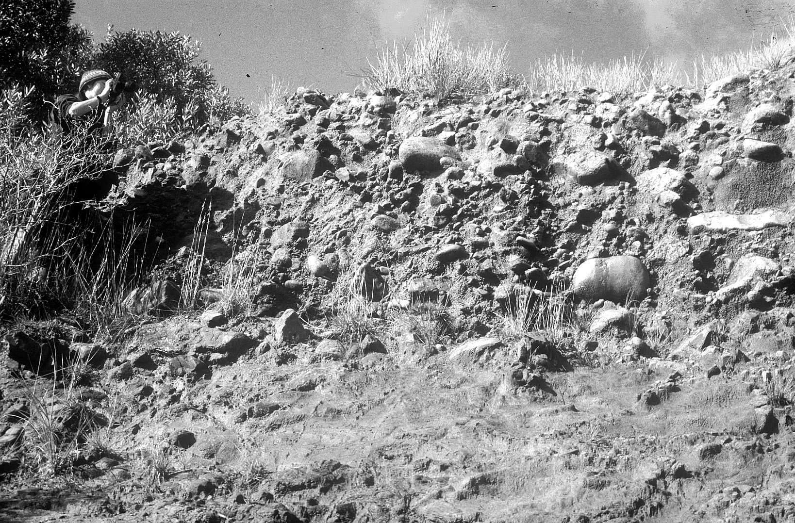 |
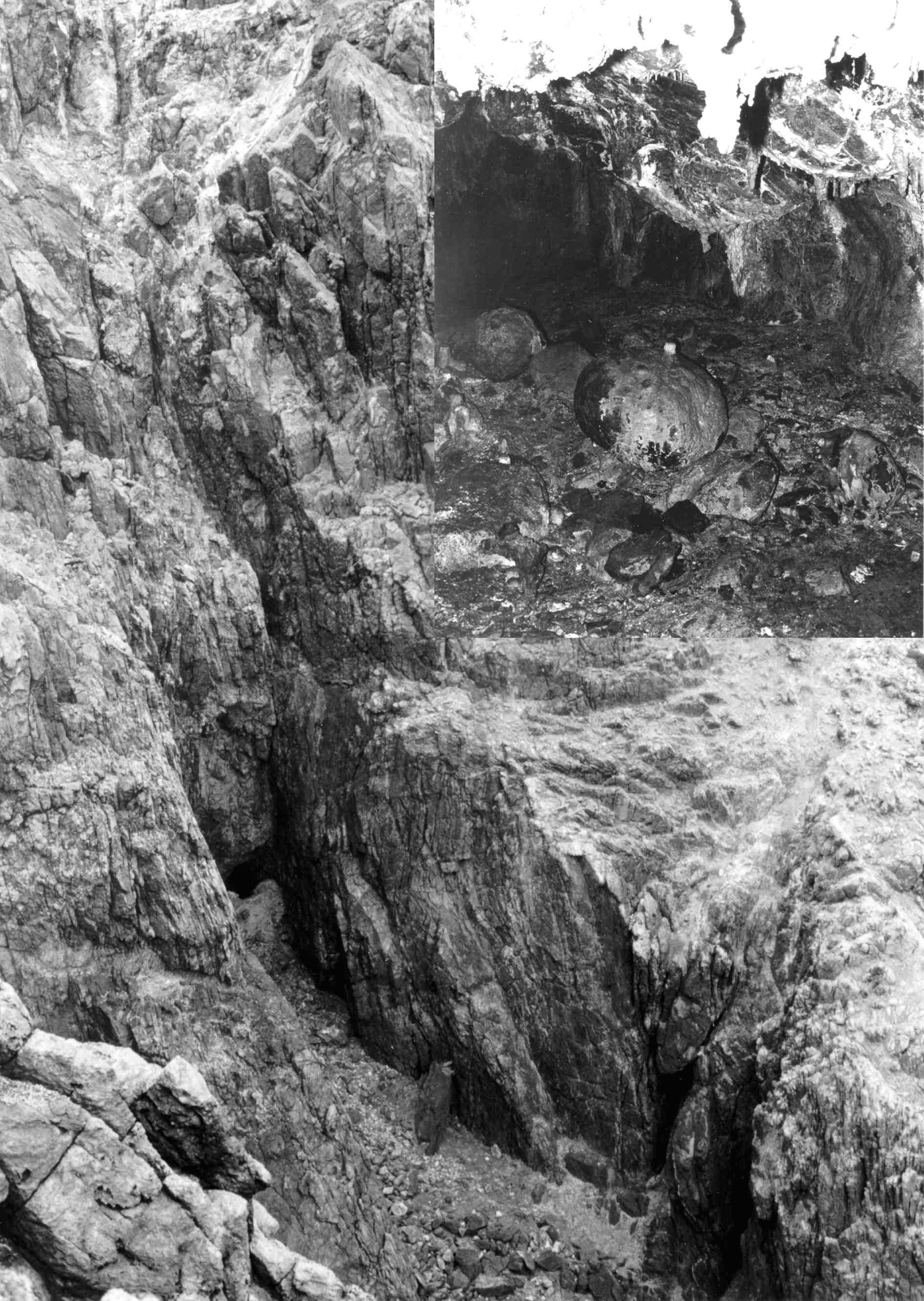
Figure 1. Left: Fossil beach deposits in Blister Cave, a raised sea cave on the west coast of King Island. Right: A raised beach exposed near Grassy on the east coast of King Island, at a similar elevation to Blister Cave. Dating of the speleothem growth on the large boulder would provide a minimum age for the beach deposits both within the cave and at similar elevations on the surface. From Jerie et al 2000 | |
If a karst area is nearby, or the river is in a karst area, it is logical to assume that, given sufficient time, horizontal cave levels should develop at this water table level (piezometric surface).
That being the case, it should be possible to correlate information from the sediments in that cave to corresponding time periods on the surface. The types of information that may be extrapolated are many and varied, including:
- Rates of valley deepening, stability or filling
- Surface climatic changes as recorded in speleothems or cave sediments
- Surface faunal composition from bone deposits in caves
For this to work though, a pretty specific set of criteria must be fulfilled, as the mere presence of rounded stones on a landscape often means little more than just that. We need to:
- Try to gauge whether the stones have come from a remote area or locally, to determine whether flowing water or waves were involved in their transport and deposition. If they have been transported, they may contain rock types not present either in the immediate deposit area or the hillslope above (in many areas, conglomerates upslope of your deposit may weather and release rounded stones - which has been known to cause momentary confusion at times). Some rounding may not be caused by transport at all. It is quite common for many igneous rocks to weather to a rounded form in the lower horizons of soils, then accumulate through slope processes or soil processes as a stone line in or on the soil. (But ... it is still possible that rounded deposits of a similar rock type to the local geology may have been transported by water if the area of that rock type constitutes much of the catchment).
- Most importantly be certain that the pile of rounded stones that you are cavorting around is actually a deposit in situ. By this I mean that they are still in the original position where they were placed by the river or waves that carried them. This may be demonstrated by digging a hole and examining the fabric of the deposits - distinctive structures are present in sediments deposited by flowing water, by wave action, wind or slope processes. A distinctive feature of river gravels (fluvial gravels), is that they are well sorted into either uniform or graded beds and commonly imbricated - that is the surfaces of stones are stacked at a more or less constant angle representing the most stable position within that flow system.
- Try to work out whether the deposit or the surrounding region has been disrupted by faulting (or other earth movements) since it was laid down. This would mean that cave deposits are no longer at the same level as nearby surface deposits. This tends not to be a problem in Australia if you are looking at material which is less than 2 - 3 million years old (and potentially much older), however I would imagine it could be difficult in NZ. (where you have to wear gaiters to stop the landscape falling off into your boots). Geological maps are the first source, however field observations will be helpful and may even contribute to future editions of the geology maps! Another potential trap in karst is that the surface below the deposit may have been dissolved away, particularly if the deposit is thin and a good acid source exists. Look for any unusual deformation in the deposits, particularly if dolines are nearby.
If these criteria are met then you may be reasonably sure that the deposit you are looking at represents a stillstand in the development of the local or regional landscape.
 |
 |
Figure 2. Cave deposits and correlated surface river terraces at Limestone Creek in NE Victoria. | |
That is, streams were not at that time incising in relation to the local bedrock mass, or sea levels remained relatively stable in relation to the land. This is corroborated if the deposits rest on a flat bedrock surface where a river terrace or ancient coastline has been planed off.
These flats in the landscape range from ancient erosion surfaces which may have developed at sea level then uplifted, to coastal terraces and river terraces (which may be graded to local base level controls) which are really just smaller versions of the same thing.
However, the flat bedrock does not need to be there - I have seen many imbricated fluvial deposits and raised beach deposits that no longer have any flatness about them at all. In limestone areas horizontal solutional notches in cliffs and outcrops are a giveaway also, particularly if (as they commonly do) they contain fluvial or coastal deposits.
If these criteria hold there is every reason to think that something correlating to the planed surface or deposit will be found underground. The same process of analysis is followed within caves - fluvial or coastal gravels, flat planed bedrock, horizontal solution notches, flat solutional roofs are all clues to local or regional stillstands all may be correlated with surface landforms by surveying levels.
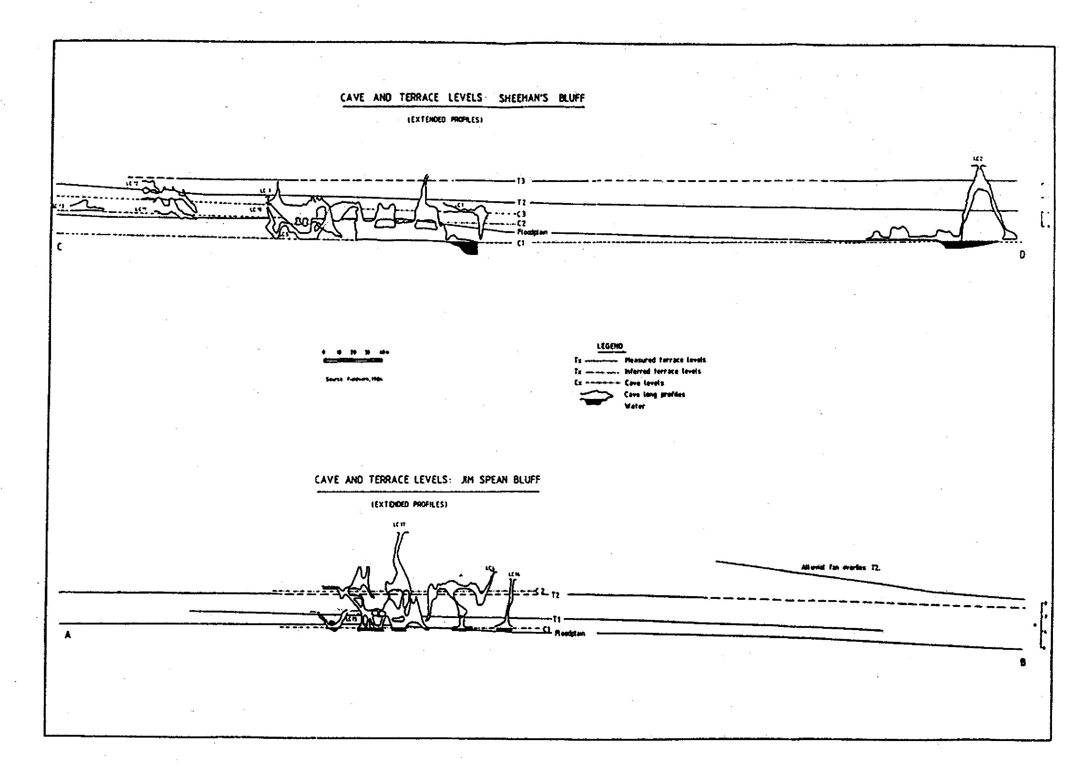
Figure 3. This diagram illustrates the relationships between inflow and outflow cave systems, and associated river terraces at Limestone Creek. From Houshold (1989)
If a correlation is found, dating and analysis of cave sediments may then reveal distinct changes in the landscape and associated environments described above.
Recent advances in dating technologies have made it possible for a wider range of deposits to be dated and much finer time resolution to be achieved than even a few years ago (to be discussed in future articles). Figures 1, 2, and 3 illustrate the types of correlation that may be made.
Old and young in the same place?
An important feature of Australian landscapes (and not just those in the Eastern Highlands!) is the juxtaposition of ancient river valleys and erosion surfaces with much younger features - often at very similar scales. Examples include the Gibbo and Mitta Mitta valleys (NE Victoria) and Porcupine Gorge and its catchment (N Qld) where young basalt flows demonstrate rapid erosion into ancient surfaces.
Some significant coastal landforms are also quite young - the magnificent 400m high flight of coastal and fluvial terraces south of Birchs Inlet in SW Tasmania has developed over the last 4 million years or so, concurrent with the gorges of the lower Gordon River.
Neotectonics - the study of relatively recent earth movement - is currently in vogue after a period in the dark ages where every Australian landform had to be ancient as if by decree. Significant, recent uplift in Gippsland, Western Victoria, Southwest Tasmania and even the Flinders Ranges has recently been proposed by Melbourne University's Mike Sandiford and others (eg Holdgate et al 2003), but many of the associated landforms have no datable deposits or basalt flows to determine their age. If the uplift has been recent, this raises the possibility of relatively young caves in associated areas such as Princess Margaret Rose, Buchan, the Lower Gordon and central Flinders Ranges karsts (and the potential for these caves to provide information about related surface landforms).
So, where there is no datable basalt in a young landscape the caves might come to the rescue, through correlations described above. Because caves may be found along the length of a river system they may also tell us how the river has eroded its valley as well as how long it took. In the Eastern Highlands, cave systems whose levels have been controlled by nearby ancient coastal plains such as the Exit system, Hastings and the Macleay valley karsts are likely to have developed in response to the slow incision of graded rivers. If so they are likely to be relatively old. A similar story is likely for systems on the highlands crest. However, karst areas which straddle the Great Escarpment such as Bungonia, Yarrangobilly and Cooleman Plain, containing elements of the ancient highlands crest landscape along with a very much younger gorge system, can potentially be used to trace the history of recent nickpoint retreat (look it up!) in a very actively incising landscape - young and old caves in the same place. In Tasmania, glaciers have carved valleys hundreds of metres deep in the order of hundreds of thousands rather than millions of years. Again, the potential for old and very young caves in the same area.
Armstrong Osborne's excellent work on palaeokarst deposits of karst areas in the central parts of the NSW Great Escarpment has also raised interesting questions about the age of caves and surrounding landscapes. Whilst it has been possible to demonstrate the great age of some elements of cave systems in a purely geological sense, it has been difficult to reconcile the apparent lack of a relationship between surface landforms and the ancient caves he describes.
The growing realisation that hydrothermal and deep sourced CO2 (or even sulphuric acid driven solution) may have developed some significant cave systems at great depth in carbonate rocks could go some way towards reconciliation. We know that these deep sources of acid water do not rely on surface inputs of CO2 to develop caves, and hence are not necessarily constrained by well known principles of near-surface hydrogeology. It means that caves of great age may develop far beneath the surface, only to be revealed as rivers and streams cut down to intersect them, potentially many millions of years later. What you would then expect is a second phase of cave development intersecting ancient hydrothermal passages, but showing strong genetic relationships with surface landforms.
Many parts of Jenolan and Wombeyan Caves in particular show elements of both styles of development, often interacting in complex ways. In Eastern Australia progress of cave and associated surface geomorphology will involve differentiating the ancient free-form hydrothermal systems from modern horizontal components associated with the incision and filling of surface rivers and gorges.
New dating and sediment analysis techniques will help constrain ages and rates of development. What has been a dilemma for Eastern Australian karst geomorphology for over 40 years may now potentially be reconciled.
REFERENCES
Holdgate, G. R., Wallace, M.W., Gallagher, S.J., Smith, A.J., Keene, J.B., Moore, D. and Shafik, S. 2003 Plio-Pleistocene tectonics and eustacy in the Gippsland Basin, southeast Australia: evidence from magnetic imagery and marine geological data. Aust. J. Earth Sci. 50 (403-426)
Houshold, I. 1989. Resources and management of karst in the Pilot Wilderness and Cobberas-Tingaringy National Park. in Good, R (ed) The scientific significance of the Australian Alps. Proceedings of the first Fenner conference pp. 370-379
Jerie, K. Houshold, I. and Watt, E 2000 Report on the conservation and management of rivers and streams of King Island. Unpub. rept. Dept Primary Industries, Water and Environment, Tas.