As I described in a previous article (Ins and Outs of Karst, ACKMA No 59), karst geomorphologists are basically storytellers - our stories revolve around the history of the different processes that have controlled the development of the Earth's surface (and subsurface). Stories are backed up by theories which are continually being tested and refined. We operate on two basic approaches - process geomorphology focuses on the accurate measurement of rates of landform development going on today. Historical geomorphology uses clues from the landscape to deduce how those rates have varied over timescales well beyond which we could ever hope to directly measure. One of the most fascinating aspects of our science is looking at the anomalies between the two approaches and how they may be explained.
For example, almost without exception if today's limestone solution rates (such as those measured over many years by Joe Jennings at Cooleman Plain) were extrapolated back to what we now know to be the age of the Eastern Highlands, Cooleman Plain would have virtually no limestone left at all. Clearly, rates vary over time - it is the job of the historical geomorphologist to explain those variations.
It is often repeated that Australia is a very old landscape, and in many areas that is true. It is also generally very flat, meaning that much of the historical evidence we have to work with is compressed into a small vertical range. In many frustrating cases the scale of landforms of different ages is similar, so geomorphic evidence overlaps in space and time. These areas are best avoided.
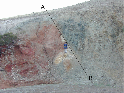
Other areas such as mountain gorges and valleys, and some coastal areas have been eroded or uplifted quickly enough to avoid most of this confusing overlap. Mike Sandiford at Melbourne University has recently demonstrated some spectacular examples of recent earth movement in the Flinders Ranges, SE S Australia and Western Victoria (Sandiford 2004: Fig 1).
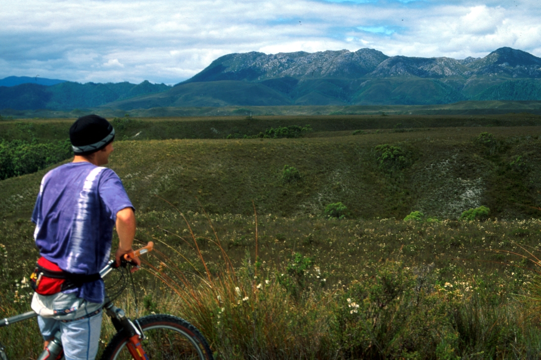
These are likely to have affected karst systems in those areas. In Southwest Tasmania there are also spectacular examples of landforms and landscapes which have developed as a result of uplift over the last 2-3 million years (Fig 2).
 |
 |
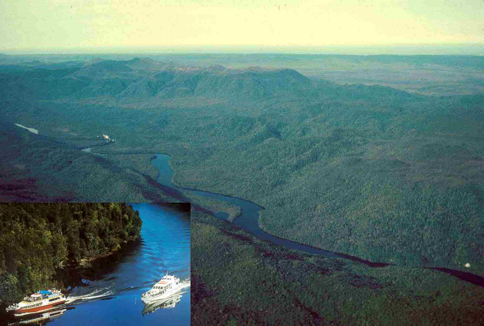 |
Figure 1. Milendella Fault in the Flinders Ranges (A-B). The west-dipping Milendella fault thrusts Cambrian metamorphics (550 million years old -dark, right) over Quaternary mottled clays (<2 million years - left). Photo: Mike Sandiford |
Figure 2. Terraces on the Sorrell River, Birchs Inlet. The high terrace on the D'Aguilar Range (background) is 300 m above sea level. Cyclo-geomorphologist Damon Telfer in the foreground. |
Figure 3. The Lower Gordon karst, Birch's Inlet terraces (background) and cruise boats (inset) |
I have just begun a program (with Mike, John Chappell [ANU] and Kevin Kiernan [UTas]) to investigate the implications of this for the geomorphic history of the Gordon River valley in SW Tasmania, using the relationships between cave and karst features in the Gordon and surface landforms at Birch's Inlet. Every now and then I'll update ACKMA on the progress of the work to describe the process of unravelling one of these stories in my part of the world.
Luckily some new dating tools are available, which may be universally applied in karst areas in our region. Twenty years ago, when I first attempted this work, uranium series speleothem dating methods were very coarse, required large amounts of sample, and were not particularly sensitive to low concentrations of uranium in samples. These days methods are much improved, allowing previously (and frustratingly) undatable samples to be successfully analysed. We hope to use them in our work, and potentially many will be applicable at cave and karst landscapes throughout the region.
Recent advances in Uranium series dating techniques.
The most common form of uranium series dating relies on accurate measurement of small quantities of Uranium-238 and 234 in a speleothem and comparing that ratio with the concentration of Thorium-230 incorporated in the crystal structure.
As Thorium-230 is insoluble, any present in the speleothem could have only come from two sources: stuck to pieces of dust or other solid detritus blown or washed over the developing speleothem or grown in situ as a daughter product of the decay of uranium. The first source has to be excluded from the analysis, and if this is possible the ratio of uranium to thorium can then be used to provide an age for the particular growth band in the speleothem being analysed.
In the past, concentrations were measured by alpha counting - measuring the rate at which atoms of radioactive uranium and thorium are presently decaying (giving off alpha particles at a rate proportional to their concentration). Because this doesn't happen very quickly, large lumps of sample were needed to provide enough alpha particles to measure, and long counting times were often needed too. Inaccurate, expensive and environmentally questionable.
These days, mass spectrometers are being used more and more to directly measure the concentration of individual elements. Single growth bands may now be targeted. Thermal ionisation mass spectrometry is the most sensitive of these methods, allowing samples from individual growth layers to be dated back as far as 600 000 years, rather than the 350 000 year limit of older alpha counters.
From our perspective it means that scientific sampling is more environmentally sensitive than even ten years ago, and researchers have developed miniaturised coring devices to extract only what is necessary from a speleothem in situ, rather than having to break it to take the whole thing back to the lab. In many cases it is possible to hide the scar from view, or use a combination of epoxy and drill dust to 'rehabilitate' the core site. As karst managers we need to ensure that these scarce and effectively irreplaceable resources are used appropriately, and most importantly to ensure that any unused sample is properly stored and catalogued, to allow future work as technology advances.
More exciting are recent advances in the use of uranium and lead isotopes which potentially expand the dating range from 600 000 years to a few million years (or maybe further). Lead is the stable end point of the uranium series decay chain, however in the age range important to geomorphologists the concentration of lead which has developed as a result of uranium decay is usually very low - until now beyond the capability of spectrometers to accurately detect. Also, in a similar way to thorium, detrital lead potentially contaminates samples giving inaccurate measurements. However, John Woodhead at Melbourne University believes he is on the verge of cracking this method and has successfully carried out trials on speleothems apparently 2-3 million years old. If successful, his method will allow a frustrating gap to be plugged in the datable age range of speleothems, associated cave deposits and surface landforms.
Cosmogenic Isotope dating
What a wonderful name! Apart from visions of 1970s psychedelica it conjures up visions of the earth spinning in a cosmic mist, gradually being infused with the radiations of the universe. People who use the method call it "cosmo", often with a wistful glance to a misspent youth.
Cosmo dating relies on the fact that cosmic rays - sub-atomic particles coming from space that continuously bombard the Earth - cause reactions in the atomic nuclei of some minerals at the Earth's surface, splitting them to create lighter nuclides. Some of these are radioactive. The most useful of these reactions occurs when elements within quartz (SiO2) grains are split - the Silicon converted to radioactive Aluminium-26 (26Al), and the Oxygen to radioactive Beryllium-10 (10Be). These new particles then remain in the quartz grains and build up at a known rate over time - with 26Al being built up at a rate six times faster than 10Be. Because they are radioactive they also decay, so eventually a balance is achieved with an 26Al:10Be ratio of 6:1 (Granger & Fabel 2005).
This allows us to use cosmo to date sediments in two ways: exposure dating and burial dating.
Exposure dating is possible whilst the cosmogenic nuclides are currently being built up to equilibrium. If, for example, quartz grains (either eroded from primary veins, or which have been long buried) are deposited at the surface there is a certain, known time it will take for a concentration of 26Al or 10Be to be built up (the rate of cosmic ray bombardment is assumed to be constant). This allows quartz-rich surface sediment deposits such as river terraces or glacial moraines to be dated if you can demonstrate that initial concentrations of 10Be or 26Al were initially negligible (or if not, a constant correction may be applied).
Burial dating may be used to work out how long a quartz-rich sediment has been buried in a cave, remote from cosmic rays (where 26Al and 10Be are no longer produced). Because both 10Be and 26Al are radioactive, and their half lives are different, measuring the ratio of the two nuclides and how it differs from the original 6:1 allows us to work out how long it has been buried.
Cosmo requires the use of very sensitive accelerator mass spectrometry to measure the concentration of nuclides. With sufficient precision it is theoretically possible to produce dates for samples buried up to 5 million years before present, however the method is not yet as accurate as uranium series dating - sometimes errors of 100 000 years must be expected for burial ages.
Birchs Inlet
In our Birchs Inlet study, Keith Fifield at ANU has used 10Be to produce exposure dates on three river terraces and the current bedload of the stream. Dates range up to an age of 600 000 years before present for the highest terrace sampled so far, at 145m above sea level (the highest surface is at approximately 400m asl at Flat Top Hill, above the Gordon River estuary). Our work suggests that major terraces in the area were developed in interglacial stages, with subsidiary terraces formed in glacial stages. Very roughly, this allows us to calculate an uplift rate for the area on average 0.1m per 1000 years - very fast compared with, for example, the Eastern Highlands. This rate will no doubt be modified as further ages are calculated.
Because the river terraces appear to merge into coastal terraces and associated beach deposits it may be possible to correlate sea-level changes with development of river terraces. Also, we intend to look for sediments suitable for dating, using both uranium series and cosmo, in uplifted caves and stranded sediment deposits along the Gordon River, inland from the Macquarie Harbour. Comparing uplift rates at both inland and coastal sites will be interesting, to see how the age of surface landforms and caves in this 'intraplate' area compare with those in the Eastern Highlands (Houshold et al, 2005).
Cruises across Macquarie Harbour and into the lower reaches of the Gordon River allow well over 100 000 people per year to experience this special landscape of pristine karst and active landscape development (Fig 3). We aim to integrate these stories of the landscape into the visitor interpretation program for the area as results emerge from our investigation.
REFERENCES
Granger, D. E. & Fabel, D. 2005. Cosmogenic Isotope dating. In: D. C. Culver & White, W. B. 2005. Encyclopedia of Caves. Elsevier.
Houshold, I., Chappel, J. & Fifield, K. 2005. Geomorphic response to intraplate neotectonics - Birchs Inlet, SW Tasmania. Paper abstracts, 12th conference Australian and New Zealand Geomorphology Group, Taipa Bay.
Sandiford, M., Wallace, M. & Coblentz, D. 2004. Origin of the in situ stress field in south-eastern Australia. Basin Research 16: 325-338.