Ecosystems at Risk: Limestone caves
Name:
1. Introduction
1ai. Define the terms:
| ecosystem: |
|
| troglobite: | |
| speleothem: | |
1aii. Explain why caves are 'ecosystems at risk'.
2a. World Location
 a.
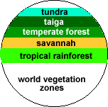
Vegetation forms general latitudinal bands around the world with tropical
rainforests near the equator and tundra near the poles. However the location
of limestone geology where limestone caves form does not follow a similar
neat zonation. Describe limestone geology under the following headings:
a.
Vegetation forms general latitudinal bands around the world with tropical
rainforests near the equator and tundra near the poles. However the location
of limestone geology where limestone caves form does not follow a similar
neat zonation. Describe limestone geology under the following headings:
| 2ai. latitude | |
| 2aii. continuity | |
| 2aiii. size and shape | |
2aiv. describe the world location of limestone caves.
2av. List the countries with the 5 longest and 5 deepest cave systems.
| Countries with the longest caves. | Countries with the deepest caves. |
New South Wales, location
2avi. Name 5 towns located near limestone caves.
2avii. Describe the continuity of cave areas in New South Wales.
2b. Topographic Map
2bi. What features are located at the following grid references (GR):
| i. GR345453 | ii. GR343454 | iii. GR351459 |
2bii. What are the approximate straight line distances of:
| i. Radio Hut to Jersey Cave | ii. Thermal Pool to Jersey Cave | iii. Jersey Cave to Ranger Station |
2biii. What is the altitude of the following features:
| i. Radio Hut | ii. shed at GR 349449 |
2biv. North is to the top of the map. What is the direction of:
| i. Ranger Station from Thermal Pool | ii. Thermal Pool from Glory Hole Cave |
2bv. Landform
Describe the general landform using all of the information on the page.
3a. Climate
3ai. How does the climate inside caves differ to that outside? List 5 of the major differences.
3aii. Name the three main climatic zones in caves.
3aiii. Compare the seasonal temperature range inside caves to that outside in the Yarrangobilly area.
3aiv. In which months of the year is the temperature inside the caves warmer than the average daily temperature outside.
3b, c&d. Climate of the entrance, twilight and dark ecosystems
3bi. Fill in the following table after calculating the readings. Record
the light and wind readings for 10 seconds then obtain the averages and
record them.
| climatic element |
entrance
|
twilight
|
dark
|
| air temperature (deg. C) | |||
| relative humidity (%) | |||
| light intensity (lux) | |||
| wind speed (m/s) |
3bii. Describe how the following change as you go deeper into the cave:
a. air temperature
b. relative humidity
c. light intensity
4a. Landform: cave formation
| 4ai. What is the term which describes the breaking down of rock? |
|
| 4aii. Which type of weathering, physical or chemical, is mainly responsible for cave formation? |
|
4aiii. Name the weak acid responsible for the dissolving of limestone
and state where most of the carbon dioxide for its formation comes from.
4aiv. How did the limestone for these caves form and how long ago did this occur?
| 4av.. Soil forms from weathered rock. Soil acidity is an important soil characteristic. What is the approximate pH of the small soil sample tested? |
|
 4b.
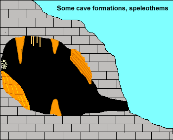
Landform: speleothem formation
4b.
Landform: speleothem formation
4bi. Write the names of speleothems (cave formations) on the diagram.
4bii. Explain how stalactites form.
4c. Landforms: catchments
4ci. What term is used to describe limestone areas and what are some of the major landform features found there?
![]() 4cii.
Calculate the average gradient from spot height 1143 m to the river at
the Natural Bridge.
4cii.
Calculate the average gradient from spot height 1143 m to the river at
the Natural Bridge.
(gradient = difference in height divided by horizontal distance and is
expressed as a fraction)
4ciii. Why might using this gradient give the wrong impression if you used it to describe landform here?
4civ. Construct a transect from spot height 1143 m to the river at the Natural Bridge.
4cv. Explain why are limestone areas often dry on the surface?
5a. Ecology
5ai. What do food chains show?
5aii. Explain how are cave food chains different to typical forest food chains?
5b. Ecology: food chains
5bi. Describe how species diversity (the number of different types
of plants and animals) and biomass (the weight of plant and animals in
an area) vary as you move deeper into a cave from the entrance?
5bii. Compare the world averages for the biomass of tropical rainforest and dark cave ecosystems?
5biii. Describe cave floor and cave roof communities.
5c. Adjustments to stress
a. Fill in the following table.
| Features of the cave environment | Animal adaptations to the cave environment |
6. Change
a. Explain why most cave animals are unable to survive minor changes
to the cave environment.
 7a.
Human impact in catchments
7a.
Human impact in catchments
7ai.Explain why human activities in cave catchments have a large impact on the caves which are underground?
7aii. List some of the activities people do which change cave catchments.
7aiii. Draw a precis map in the space showing human changes shown in the Yarrangobilly air photo.The topographic map on page 2b will help.
7b. Human impact in caves
7bi. List the different changes made to show caves to allow guided tours.
7bii. Describe some of the impacts people have on caves when the visit them.
8a. Catchment Management
8ai. Explain how the government has protected caves.
8aii. Why is catchment management important?
8aiii. Give three examples of catchment management in the Yarrangobilly and Cooleman Plain areas to protect the caves.
8b. Cave Management
8bi. Name the 6 categories of caves in the NPWS cave classification system often used to assist cave management?
8bii. List 6 of the specific cave management methods used at Yarrangobilly.
8biii. Explain the dilemma for the NPWS when managing caves?