Ecosystems at Risk: limestone caves
management scenario:
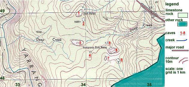
Source: © Land and Property Information Panorama
Avenue Bathurst 2795
Cave features:
- 1. large cave with vertical shafts which require abseiling
- 2. small cave with bat colony and cave floor beetles living on bat guano
- 3. large cave which floods rapidly after storms
- 4. small cave with good variety of speleothems
- 5. good range of speleothems but they are not scientifically valuable
- 6. large cave with easy access, variety of speleothems but do not warrant special protection
- 7. cave has large chambers with variety of speleothems but human access is difficult because of very small entrance and narrow passages between large caverns
- 8. large cave with small creek, easy access, variety of speleothems
Development Proposal
The present Yarrangobilly Caves site has been suffering from over use.
Visitor numbers have exceeded the carrying capacity of the public access
caves and the speleothems are getting damaged and cave temperatures have
been rising 1.5 deg. during tours, from human body heat. You are a member
of the NP&WS Speleological Planning Team and have been asked to investigate
the opening up of a new site shown on the map above which is about 10
kms from the present site shown. (For the purposes of this exercise the
original map has been modified to include and area of granite, a non limestone
rock.)
The Planning Team will submit a report to the Director, NP&WS for her consideration. In you report you will include the map above to show any proposed infrastructure developments and a written explanation. Keep in mind that although there are only 8 cave entrances shown, the caves themselves, extend under the whole limestone area. You will need to:
- give each cave a classification using the NP&WS scheme below;
- decide which caves you will allow public access to;
- the location of infrastructure including walking tracks, roads for vehicle access, toilets, ranger office and information buildings and car parks for cars and buses (consider the impact of soil erosion, possible water pollution and construction on the caves beneath);
- you have been asked to pick the best position for an over night tent camping area. It is very unlikely this would be allowed but the boss has asked for it to be included for discussion purposes.
- Whether you like it or not, people will walk to the river, it is a focal point. They will take their lunch and spend some time there. You need to include a walking track to the river so you can plan the safest route and the one which will cause the least damage to caves from soil erosion.
Prepare a management plan for each cave you decide is suitable for public access. How will you allow public access but at the same time protect them for sustainable use? You will need to consider:
- location of access tracks to the entrance
- internal cement paths and steps will destroy cave floor ecosystems and their construction will cause much damage. Is there an alternative?
- Protection from visitors who should not be there, perhaps either they have not paid for admittance or do not have a guide.
- Lighting systems for safety and the display of special features require wiring and the installation of other equipment. Is there an alternative?
- Are any caves suitable to be self-guided or will they need a guide?
- How many people will you allow in a group inspecting a cave?
- Will you allow accredited caving groups, members of the Australian Speleological Federation, to use some caves which are normally closed to the public? If you allow this, how will you manage it?
Prepare a Fieldwork Plan to investigate the impact of people on Cave 8 one year after you have implemented your management plan.
NP&WS Cave Classification Scheme.
Category 1. Public Access which are open to the public and have
been developed as public inspection caves either with a ranger or as self-guided.
Category 2.1 Special Purpose caves are managed to keep them as unmodified as possible consistent with some recreational use. Two caves have been set aside at Yarrangobilly as scientific reference caves to protect their faunal communities. Access to these will be by bona fide scientific researches holding NP&WS Scientific Consents. Other caves will only be entered in the company of NP&WS staff. Levels of visits are be closely monitored.
Category 2.2. Outstanding Natural Value caves are also subject to limitations on numbers and frequency of visits but not as strict as 2.1 caves. Parts of category 2.2 caves may be classified as 2.1.
Category 2.3 Dangerous No caves at Yarrangobilly have been classified as 2.3. Several entrances to the Glory Holes caves have been classified as 2.3 to avoid dangers to tourists from cavers above.
 Category
3.1 Wild Caves There are about 120 wild caves at Yarrangobilly which
require permits from NP&WS to enter.
Category
3.1 Wild Caves There are about 120 wild caves at Yarrangobilly which
require permits from NP&WS to enter.
Category 3.2 Unclassified Caves are closed to access until classified.
Good luck and remember the future of the caves depends on you, don't stuff it up.