A
Field Guide
to
BENDETHERA CAVES
by
Illawarra Speleological Society Inc.© 2002
MAP
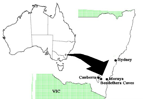
SHOWING LOCATION OF DEUA NATIONAL PARK
GENERAL DESCRIPTION OF THE
LANDFORMS
SUGGESTED CAVE
CLASSIFICATIONS FOR BENDETHERA KARST 2002
Return to the
Bendethera Title page
Return
to the Welcome Page of this CD
PURPOSE OF THE FIELD GUIDE
Over 110 years ago, caves were found at Bendethera!
In the late 1950's and early 1960's, the Wollongong Speleological and Expeditionary Group searched for the caves but to no avail. In October 1960, Jim Goold and Lloyd Robinson found the caves after spending a week in the area. From then until May 1963 when the Illawarra Speleological Society (ISS) was formed, only a couple of trips to the area were undertaken.
From May 1963 to 1973, numerous trips to the area occurred, and a great deal of time and energy was expended in enlarging BD-2, the Efflux, but with little result. Most caves were tagged and very general locations were entered on a map that O. Trickett drew almost 70 years previously. In the late 1970's when the area was incorporated into the Deua National Park, ISS ceased research into the area.
Since the 1980's many caving groups returned to the area to again search for the elusive caves - a few new caves were found and few caves were surveyed. Unfortunately, much of this work was duplicated and there was an uncoordinated approach into the investigation of the karst.
Little scientific research has been conducted in the area, save a hydrology study in 1989, a vegetation study in 1981 and a few geological studies in the 1890's.
The purpose of this guide is, therefore, to be a compilation of all known information about the area that has been undertaken since the caves were discovered. Only a few copies of the guide will be published for those who are still investigating the karst at Bendethera to allow for a systematic approach to the study of the caves and associated scientific studies, and to stop the futile duplication of effort by speleologists in the 21st century.
This guide will also assist in the revision of the Deua National Park Management Plan and increase the knowledge of the karst resources.
Hopefully future scientific investigations could include:
v further hydrological studies;
v surface mapping;
v geology of the caves; and
v cave fauna studies.
Wolfgang Stengal reported that "the Main Cave, BD-1, had deteriorated greatly since he last saw it in the early 1970's." ISS Newsletter Volume 3 no 5 December 1996 page 10.
A study of visitors by ISS over the year September 1999 to November 2001 showed that at least 1000 people had visited the cave. Many had not signed the visitor’s book - personal observation in October 1999 by Bob Kershaw, so the true figure could well be over 1200 people per annum. The heaviest traffic times are Easter with 200 people and October and January holidays.
The information on cave locations must be strictly
controlled so as to minimise environmental degradation as mentioned in the
statement above, both on the surface and in the caves themselves, with the
exception of BD1, which is already well known to many bushwalkers, horse riders
and 4W drive clubs.
As stated on the NPWS and Eurobodalla Shire Tourist information web pages:
With the exception of Bendethera Main Cave and the first 200m of Wyanbene Cave, permits are required for caving from the NPWS Narooma District Office,
phone (02) 4476 2888.
LOCATION
Bendethera Caves are found at 35o 55' S latitude and 149o 42' E longitude in the central south- western part of the Deua National Park, just below and east of the Minuma Range, approximately 250 kilometres south of Sydney and 40 kilometres west of Moruya.
The Caves are located between Con and Little Con Creeks, in the headwaters of the Deua River, which is an upstream tributary of the Moruya River.
Bendethera is one of a related group of caving areas known collectively as the Upper Shoalhaven Karst Region. These are, from north to south, Cheitmore (or Cleatmore), Marble Arch, Big Hole, Wyanbene and Bendethera.
The Deua National Park covers some 117, 557 hectares in some of the most rugged ranges in southeast New South Wales.
The caves are accessible from the West via the Dampier Mountain Fire Trail or via the Sugarloaf and associated fire trails from Moruya (the easier access). Both of these routes require 4WD, although one 2WD vehicle has been known to travel into the camping ground from Moruya.
MAP SHOWING LOCATION OF DEUA NATIONAL PARK
An excellent location map can be found on page 42 of John and Jan Tait's 4WD
Weekends published by Gregory's in 2000.
On page 40 to 43 is an excellent description of the route taken from Moruya to travel into Bendethera.
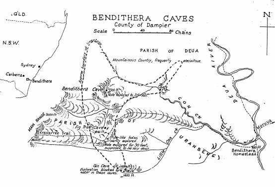
Oliver Trickett’s original map of Bendethera
GENERAL DESCRIPTION OF THE LANDFORMS
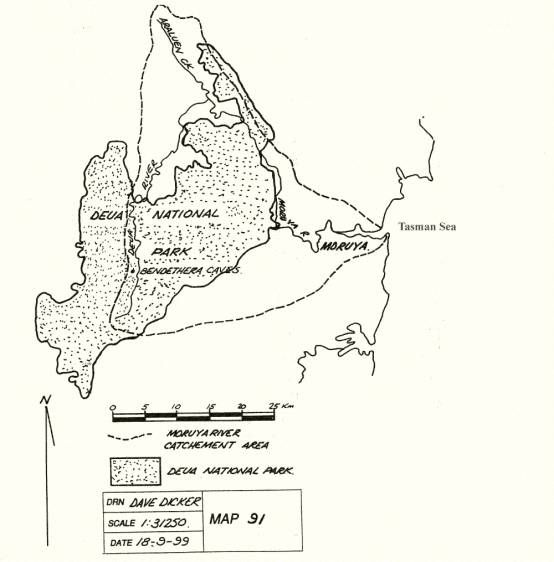
Bendethera Caves are apart of the triangular shaped Moruya River catchment that drains an area of approximately 1,500 square kilometres. The upper part of the catchment of which the caves are situated are in the rugged ranges of the central part of the Deua National park.
The Minuma range is at the western extremity of the Moruya River Catchment and near the caves are the headwaters for Con and Little Con Creek that flows into the Deua River near where the Old Homestead was located.
The topography of the caves area is rugged and steeply incised valleys. The highest areas, on the Minuma range, of 1000m provide the backdrop for summer orographic rainfalls and protection of the region from the drying westerly winds in summer and cold winds of winter. To the west of the Minuma range is the area known as the Krawarree region and this area is the headwaters of the Shoalhaven River, which eventually reaches the sea at Nowra.
The caves are generally found in the range of 450m to 650m ASL.
The Deua National Park covers an area of over 80,000 ha, a great deal of which is wilderness. The Deua River flows north-south through the centre of the catchment and to the east of the caves. The only vehicular access to Bendethera is from Moruya, approximately 30 kilometres to the east via the Sugarloaf Fire Trail, or from the west and south via the Minuma and Dampier Mountain Fire Trails. To reach the caves the vehicles must be left at the car park and speleos and the general public have to walk approximately three and half kilometres to BD1.
CLIMATE
This region in South Eastern NSW experiences a Warm Temperate Eastern Maritime Climate, with hot summers and mild winters. The escarpment to the west of the Deua River and the caves, that is the Minuma Range, provides shelter from the hot and drying north-west summer winds and the cold south-westerly winter and spring winds. The Australian Alps also assists in protecting the region from the westerly winds. As a result, the months from August to November are relatively dry. However, the escarpment provides the impetus for afternoon summer and autumn thunderstorms as the escarpment enables the formation of precipitation by orographic methods.
Heavy rains are often the result of deep low pressure systems off the south coast pushing warm, moist air on-shore. These systems occur approximately twice per year and can bring rains in excess of 350mm in a 24hour period. Other heavy rainfalls occur with the advancing cold fronts in summer as they pass across the region. Floods at Moruya are more likely to occur in the months from February to May.
The difference in rainfall is quite noticeable between the coast and the caves area as the mean annual rainfall at Moruya Heads is 967mm while for Bettowynd where records were available from 1897 to1967, give a mean of 744mm. Bettowynd is approximately 20kms north of the caves area.
It has been noted in the study of the rainfall records that rainfall at Bettowynd has increased over the record keeping period:
648mm from 1897 to 1914;
697mm from 1915 to 1932;
798mm from 1933 to 1950; and
878mm from 1951 to 1976.
Mean Rainfall record for Bettowynd for 71 years from 1897 to 1976(mm)
|
J |
F |
M |
A |
M |
J |
J |
A |
S |
O |
N |
D |
Yr |
|
74 |
76 |
74 |
60 |
64 |
65 |
53 |
44 |
48 |
62 |
57 |
67 |
744 |
However extremes of rainfall can occur which is typical
of the unreliable and erratic nature of rainfall in Australia. This is shown in
the table below from the records of Bettowynd.
|
|
J |
F |
M |
A |
M |
J |
J |
A |
S |
O |
N |
D |
|
Highest |
343 |
355 |
298 |
361 |
696 |
263 |
431 |
193 |
230 |
420 |
344 |
216 |
|
Year |
1934 |
1898 |
1961 |
1945 |
1925 |
1913 |
1922 |
1901 |
1962 |
1959 |
1961 |
1960 |
|
Lowest |
2 |
2 |
0 |
1.5 |
0.5 |
0 |
0 |
1.8 |
0 |
1.5 |
1.5 |
6 |
|
Year |
1932 |
1902 |
1922 |
1911 |
1901 |
1953 |
1943 |
1948 |
1930 |
1900 |
1926 |
1946 |
Temperatures for the area are not available but a
comparison with Moruya will give some indication of the monthly and seasonal
variations. A degree or two should be subtracted for the caves for winter and
added for summer as they are at about 500m ASL.
|
|
J |
F |
M |
A |
M |
J |
J |
A |
S |
O |
N |
D |
|
Mean max |
24 |
24 |
23 |
22 |
19 |
17 |
16 |
17 |
19 |
20 |
21 |
23 |
|
highest max |
42 |
43 |
40 |
33 |
28 |
24 |
24 |
29 |
35 |
36 |
42 |
41 |
|
Mean min |
16 |
16 |
15 |
12 |
9 |
7 |
6 |
6 |
8 |
11 |
13 |
15 |
|
lowest min |
8 |
9 |
6 |
5 |
2 |
0.5 |
0 |
0 |
1 |
3 |
5 |
6 |
|
mean |
20 |
20 |
19 |
17 |
14 |
12 |
11 |
12 |
14 |
15 |
17 |
19 |
Hot summer days are often experienced and low temperatures in winter when cold
clear skies exist. Frosts often occur at the camping sites
along the Deua River and last until midday if in the shade in winter.
The area experiences strong winds under the following conditions, which often accompany heavy rainfall:
1) easterly to southerly winds that are associated with the deep lows off the NSW south coast;
2) strong west to NW winds as the pressure gradient steepens ahead of an approaching southerly change;
3) strong gusts associated with afternoon thunderstorms.
The mean relative humidity (%) is also an indication of
the coastal nature of the region, the rainfall patterns and associated general
wind pattern over the area throughout the year.
|
|
J |
F |
M |
A |
M |
J |
J |
A |
S |
O |
N |
D |
|
9am Mean |
74 |
77 |
77 |
77 |
79 |
79 |
76 |
73 |
70 |
68 |
71 |
73 |
|
3pm Mean |
71 |
72 |
71 |
66 |
64 |
63 |
59 |
59 |
62 |
65 |
69 |
70 |
CLIMATE REFERENCES
Bureau of Meteorology, Moruya climatic statistics
Eurobodalla Council, Moruya River Floodplain Management Study, August 1995
GUTTERIDGE, HASKINS AND DAVEY, NSW Coastal Rivers Flood Plain Management Studies-Moruya Valley, July 1981
HOUSHOLD, I. (1989) Bendethera Karst Area - Resouces and Significance NPWS
PUBLIC WORKS DEPT NSW, Moruya River Flood Study, December 1992
PUBLIC WORKS DEPT NSW, Moruya River Flooding 8-13 June 1991, November 1991
SALE, C. (1982 ) World Water in Environment and Development, Shakespeare Head press
STATE EMERGENCY SERVICE NSW, Flood Operations Manual, "The Eurobodalla Flood Plan", September 1994
WATER CONSERVATION AND IRRIGATION COMMISSION, Water Resources of the Moruya Valley, Report no 18 July 1970
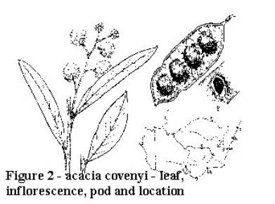
BENDETHERA WATTLE [acacia covenyii] (Blue Bush)
GLOSSARY
axil the upper angle between a leaf and the stem that bears it
axillary arising in the axil
bloom a powdery-waxy secretion
calyx lobes the free part of the calyx-segment or sepal (the outermost whorl of the floral parts)
ciliate with fine marginal hairs
mucronate with a short stiff point (mucro) often as an extension of the midrib
Phyllodes leaf-like structures, which perform the functions of leaves.
peduncle the main stalk of an inflorescence
penniveined feather-like structure
glabrous without hairs or bristles
glaucous coated with a bluish-white 'bloom'
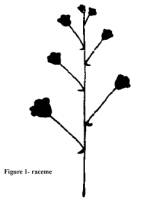
inflorescence the arrangement of a group of flowers along a stem
racemes a simple inflorescence with stalked flowers along the axis, the youngest near the top
Habitat
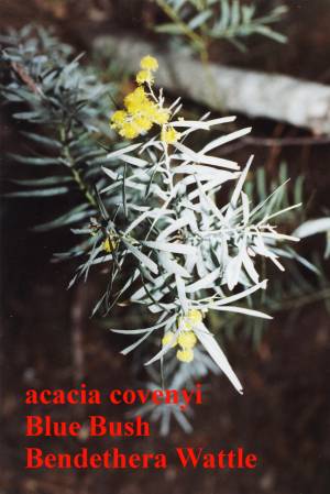 The plant is named after
R. Coveny, a botanical collector at the Royal Botanic Gardens in Sydney.
The plant is named after
R. Coveny, a botanical collector at the Royal Botanic Gardens in Sydney.
This species of wattle commonly called "Blue Bush" is endemic to the
Bendethera area of NSW growing over the limestone, and occasionally on
quartzite, that is found in the area.
It is a Shrub or small tree, 1.5-7.5 m.
The bipinnate leaves of typical wattle trees have been replaced by leaf-like structures called Phyllodes, which perform the functions of leaves. The leaves alternate, are linear and have only one main vein per face being faintly penniveined, they are vertically flattened and have a central leaf-axis 2-6 cm x 5-10 mm. The leaves are glabrous and very glaucous sometimes leaving the leaves a grey or silvery appearance.
 The apex of the
phyllodes is acute usually with an oblique, curved mucro.
The apex of the
phyllodes is acute usually with an oblique, curved mucro.
The gland is small and below the centre of the phyllode margin.
The inflorescence or Flower heads of 5-8 bright yellow flowers, flowers in spring (Aug-Sept). in racemes.
There are 5-16 heads of the racemes. The flowers are sparsely ciliate with short calyx lobes
The legumes or Pods 2-7 cm x 9-13 mm, straight and scarcely constricted between the longitudinal seeds.
FIRE
In 1968 a major fire burnt all of the limestone outcrops and killed all the surface vegetation on the limestone which resulted in major tree falls. It appears that the Acacia covenyi recovers rapidly after fire and because of its high seed production it is a resilient plant community. Again in January 2002 the area was extensively burnt from Bendethera Trig through the Duea River valley and up to Wyanbene Mountain trig.
 sketches based on
L. Costermans
Native Trees and Shrubs of South-eastern Australia
VEGETATION REFERENCES
DAVIES*, S.J. AND GILLIESON, D.S. (1985) The Limestone Flora at Bendethera
* NPWS South Eastern Region, Queanbeyan, NSW
T.TAME (1992) Acacias of South East Australia Kangaroo Press, Kenthurst
COSTERMANS, L. (1989) Native Trees and Shrubs of South Eastern Australia
Weldon Publishing Australia
A report from W.S. Leigh below is the earliest report on the geology of the
area.
Appendix No. 8A
Report in Bendithera Caves.
W.S.Leigh
Geological Survey Branch, Department of Mines, Sydney, 29 April, 1890
Sir,
I have the honour to report, as requested, on the caves recently discovered at Bendithera, near Moruya, the discovery of which was reported to the Department by Mr. Warden Maunsell. They are situated in the parish of Uranbene, county of Dampier, being about 25 miles (40 Kms) due west of the township of Moruya, about 40 miles (65 Kms) south of Braidwood, and the same distance N.E. of Cooma.The surrounding country is very rough and mountainous, and so far no roads have been made in the vicinity, the only means of access to the caves being by bridle tracks, that form Moruya, the eastern outlet, crossing some very high ranges, an altitude of over 2,400 feet (731.5m) being reached. On the western side the track connects with the Braidwood road at Krawaree, about 12 miles (19 Kms) distant, and from information received I understand that it would be quite practicable, and not a very costly undertaking, to continue the road from this side down to the caves, and thus open up a growing pastoral and mining district.
The belt of limestone in which the caves occur runs north and south, and is identical with that of Wyanbene, about 8 miles (13 Kms) south of Araluen, at which place a cave was discovered eighteen months ago, but on account of its flooded state it was not deemed advisable by the Department to take further action in regard to it for the time being.
The discovery under notice is of far more importance, three distinct caves having already been found, and considering the wide extent of limestone country here it is very probable that others, and perhaps better ones, will soon be brought to light. The principal cave is situated on the northern slope of the mountain, about 250 feet (76m) above the level of Cow Creek, which runs at its base, the waters of which rise principally from underground channels, bursting up through the limestone at two or three different places.
Passing through the entrance, an opening about 10 ft. (3m) by 6 ft.(1.8m), you stand on the threshold of a large chamber, being about 50 ft. (15m) in height by 50 ft. (15m) in width, containing some massive stalactites of a curtain-like form hanging 20 feet below the roof. Beyond this chamber the cave takes two levels, or is divided into an upper storey, being on level with the entrance. Descending by an opening to the left by an almost natural staircase leading to the lower levels, two immense columns are met with, on of which, about 20 feet (6m) in diameter and known as "The Pulpit", rises to a height of 60 or 70 feet (18m to 21m), and seems designed to support the long stretch of roof beyond. Descending 25 feet (7.5m) more the lowest level is reached, the floor at this point forming a basin containing water, the depth of which averaged 3 feet(1m), and 25 feet (7.5m) wide, being the drainage of the whole cave, caused principally by the late heavy rains. At this point the width of the cave is about 60 feet (18m) and roof, only discernible with the aid of the magnesium light, must be close on 90 feet (27m) overhead. A wall of rock, forming an angle of about 60 degrees with the horizontal, is next ascended 45 feet (14m), this being on a level with the upper storey of the cave before-mentioned. Glancing back from this point a splendid view of the entrance, 150 yards (117m) distant, is obtained, and by viewing daylight so far back after traversing the lower levels, has a very novel and pleasing effect. Beyond this is gradual ascent is made for about 100 yards (91m), when the end of the cave is reached. The floor at the extreme end is thickly covered with guano, bats being very numerous on this part of the cave.
The whole cave resembles an immense straight drive into the mountain and about 250 yards (229m) in length by an average width and height of 40ft (12m) and 50 ft. (15m) respectively. Some very fine specimens of dripstone formation, mostly massive, are met with, amongst which may be mentioned a number of fine statue-like stalagmites standing out in bold relief against the sombre background, also some large natural niches in the walls with rounded canopy-like formations fringed with fine stalactites hanging gracefully above each niche, at the floor of each is a large basin projecting form the wall and enclosing the base, some of these canopies are 20 ft. (6m) in height. A large slab of calcite, over 20 ft. (6m) in height by 4ft (1.2m) wide and 2 inches (50mm) thick, in the form of a screen projecting form the wall, attracts general attention. this slab, I am sorry to say, has been much chalked over by visitors.
The formations, as a rule, in this cave are not pure white
but of a brownish-yellow tint.
One of the other caves referred to and known as the "Gin Cave", is
about 2 miles (3.2Kms) distant from the principal cave, and being rather
inaccessible, has not yet been explored, but when better appliances for this
purpose are procurable, and important discovery will most probably result. The
other cave, about half a mile (0.8km) distant, is rather small and contains
little dripstone formation.
An area of land (1,180 acres) (478 Ha) on which the caves are situated, was reserved
from sale, for public recreation on the 22nd February last (1889).
Mr. Warden Muansell and Mr. Barlow, of Moruya, two gentlemen who have
interested themselves in the preservation of the caves, accompanied me form
Moruya and gave me valuable information as to the surrounding country, routes,
&c.
Although one or two instances of disfigurement by chalking occur in the caves,
on the whole they are in a good state of preservation, and in order that they
may be preserved to the country in this state, and that intending visitors may
rely on the services of a guide when inspecting the caves, I would suggest that
a keeper be temporarily employed, and such improvements, including gate at
entrance, carried out as deemed necessary.
Benjamin George, the discoverer of the caves, who lives within 2 miles (3.2km)
of them, would I think, be the most suitable man to employ, and as an incentive
to properly exploring the present caves and their vicinity, he might perhaps,
in the first case, be temporarily employed for, say two years at £50 per annum,
his further employment to depend principally on the amount of exploration work
carried out during that period.
W.S. Leigh
Superintendent of Caves.
Below is
another Report in the Bendithera Silver-field and Currowan and Brimbermala
Gold-field, Geological Survey, Department of Mines, 22 January 1891
[editor's definitions are enclosed within the brackets]
At Moruya there is an isolated patch of granite, whose outcrop is about 8 miles
(13 kms) in diameter. This granite has been used for the building and
monumental purpose, and is of considerable economic value, as it takes a high
polish, and is a very durable stone.
The track from Moruya to Bendithera passes for the most part through a wild and mountainous country, and has been used for a number of years by Mr. George, the discoverer of the caves and silver-lodes.
About a mile (1.6Kms) to the west of Moruya the granite junctions with the slates, and after crossing Burra Creek, about 8 miles (13Kms) out, the country becomes very mountainous and rugged. Shortly after crossing Diamond Creek and near the half-way house, another outcrop of granite is crossed, which is a southern extension of the great mass of Araluen and Major's Creek. The valley of the Dena (Deua) River, in the neighbourhood of the George's Station, is formed by Siluro-Devonian Slates. On its western slope, among these are a series of lenticular beds [lentil shaped or referring to the biconfex nature like a lens] of limestone of limited extent in which the Bendithera Caves occur, and which in some parts are encrinital [covered in crinoid fossils - those with radiating arms or with a mouth up on an attached stalk], and capped by a considerable thickness of Devonian conglomerate and shales having a decided dip to the north-west; while still further to the west another mass of granite occurs, which is probably a southern extension of Major's Creek granite.
The reefs known as the Bendithera silver-lodes are on the western slope of the Duea River Valley, in the belt of slates among which the limestones occur. Those reefs which have been discovered and partially prospected are in close relation to the limestone, and at Bendithera Silver-mining Company's claim the lode occurs in the centre of the limestone alongside a dyke of quartz porphyry, which has intruded the limestone in a north-westerly and south-easterly direction. This dyke mass evidently dips in an easterly direction, and the shaft which has been sunk upon the gossan lode [filling the upper parts on mineral veins], occurring, at its junction with the limestone, has passed through the lode into the dyke at a vertical distance of 25 feet (7.6m).
The lode stuff consists of ferruginous [iron bearing or colouring-deposit] gossan, showing a little galena [a very common heavy mineral, lead sulphide] and traces of zinc-blende [sulphide] with arsenic pyrites. Another shaft has been sunk on a blow of gossan ore, which occurs on the bedding planes between the limestones and the slates, but I do not think there is any evidence of a permanent lode of any great extent in this latter position; of the two places, the former is certainly that in which a permanent lode might reasonably be expected to occur, because of the presence of the presence of the porphyry dyke. There are, no doubt, great facilities for working this lode at a considerable depth by means of a tunnel carried in on the lode alongside the dyke, from the gully to the north, but to prospect and prove the lode to a depth, the best method would be to continue the shaft to its underlay, because the presence of the porphyry dyke would always be a guide to enable the prospectors to again pick up the lode if it should pinch out at any point. As is generally the case where lodes pass through limestone, the lateral extent of the lodestuff will be found to be very irregular locally, because of the fact that the lode and the edges of the dyke act a vehicle for the downward percolation of the surface water, which, in its course, will have excavated cavities in the limestone, many of which have no doubt been subsequently filled with lodestuff redeposited form the lode. So far as has been proved, the gossan lode is of no great width near the surface, and the assays have not given phenomenal returns of silver, still form all appearances the lode seems well worth prospecting to a depth. A bulk test of nearly one ton was made at the Clyde Works, the expense being defrayed the Government out of the Prospecting vote.
This ore was crushed and concentrated by Frue Vanner, and the assay of the concentrates yielded at the rate of 3oz. 1dwt. 9gr per ton. (Approx. 90 grams).
Some distance to the north-east another gossan lode has been partially opened up by Mr. George, the prospector. This lode occurs in the slate rocks, a short distance to the east of the limestone, Its outcrop is traceable for a considerable distance through the 80-acre (32 hectares) lease taken up by this party, and it is of considerable width. It has been driven upon for 25 feet (7.6m), and two shafts have been sunk upon it, one 10 feet (3m) and the other 25 feet (7.6m). The ore at the surface is in the form of a ferrunuginous gossan, showing galena and iron pyrites. The assays of this ore show returned of a few ounces of silver per ton, with traces of fine gold. The lode has all the characters of a permanent lode, and as the assays have only been taken from that portion of the outcrop on which the party have worked, they can hardly be sad to give a reliable idea as to the payable nature of the lode.
W. Anderson, Geological Surveyor
Annual Report 1891
Lishmund, et al (1986) The Limestone Deposits of NSW states:
The Bendethera limestone consists of two separate bodies- a large western one about 5km long by up to 750m wide, and a eastern body measuring approximately 1km long by 500m. The latter is possibly dislocated from the former by a fault trending along the upper part of Con Creek (see figure 23).
The Limestone is mid to very light grey and finely to very finely crystalline with small zones of recrystallisation. It is generally massive, but the eastern body contains several irregular ferruginous quartzite masses. Bedding is not preserved. However, a thin fossiliferous band in Bendethera cave dips towards 040 degrees M at 53 degrees. The overall trend of the western deposit is north-south while the eastern body appears to strike more to the northeast. A strong east-west cleavage is present in places.
Fossils occur in various parts of the deposits, and the Late Silurian corals Pycnostylus sp. and Favosites Sp. have been identified by (Kennedy et al 1963).
The limestone is interbedded with poorly exposed quartzite, slate, grit, fine sandstone, shale and other sediments. To the east these rocks are unconformably underlain by highly deformed slate, quartzite and chert of Ordovician age, the contacts possibly being faulted in part. To the west the silurian rocks are unconformably overlain by flat-lying purplish conglomerate and sandstone of the Late Devonian Minuma range Group, which forms the prominent cliffs of the Minuma range extending several kilometres to the north and south. The Bendethera Limestone and associated sediments probably occur in the keel of a tight synclinal structure, the limestone being dislocated by faulting to form two separate bodies.
To the north and east the sediments of the De Drack
formation are flanked by the Late Silurian Flash Jacks Volcanics (Wyborn and
Owen 1980) which consist of felsic ignimbrite and lava, agglomerate, and
airfall tuffs, and are in part equivalent in age to the De Drack Formation.
East of the Deua River these rocks occur in a large decollement (the Bendethera
Decollement - Wyborn and Owen 1980) whose boundary with the underlying
Ordovician sediments is a flatly westerly dipping faultplane. Wyborn and Owen
recorded a further small exposure of the Bendithera Limestone within this
decollement on the western bank of the Deua River about 2km downstrean from the
Bendethera Caves Fire trail crossing.
A ferruginous gossan containing sulphides can be traced along the eastern side
of the smaller limestone body in the slates and quartzites a few metres from
the contact.
GEOLOGICAL REFERENCES
Lishmund, S.R. et al 1986 The Limestone Deposits of New South Wales, Dept Mineral Resources
Lishmund, S.R. and Dawood, A. D. 1972 "The Bendethera - Wyanbene Limestone Belt" Department of Mines, NSW
Anderson, W. Report on the Bendithera Silver-field and Currowan and Brimberermala Gold- field, Annual Report of the Department of Mines, 1891
Wallis, G.R. "Report on Bendithera Caves" , NSW Geological Survey Report 1964
For many visitors to Bendethera Main Cave who walk beside and cross many times the beautiful clean clear waters of Con Creek whilst trekking on their journey to the main cave, the thought of where the water originates is of little concern.
However, to the speleologist, the source of the creek is of extreme interest and it has puzzled many of us for several years!
The catchment area of Con Creek is bounded on the west by the escarpment of the Minuma Range to a height of 1000m ASL and to the east by the Duea River at 300m.
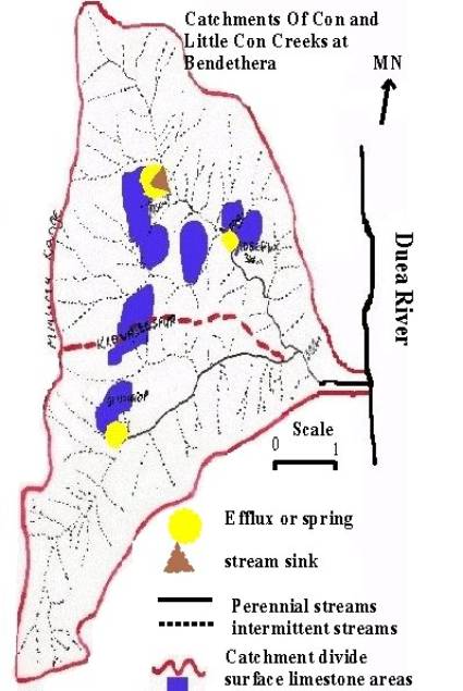 As the diagram at left
shows, the approximate 11 square kilometres of catchment for Con Creek and the
approximate 8 square kilometres for Little Con Creek, provided an almost 20
square kilometre catchment area that collects water before emptying into the
Duea River near the current Horse yards near the site of the old homestead.
As the diagram at left
shows, the approximate 11 square kilometres of catchment for Con Creek and the
approximate 8 square kilometres for Little Con Creek, provided an almost 20
square kilometre catchment area that collects water before emptying into the
Duea River near the current Horse yards near the site of the old homestead.
However, Con creek is only a perennial stream from the efflux at BD6 and Little Con Creek begins from a spring at the base of the Gin Outcrop. The rest of the creeks are intermittent.
As the year 2002 heads into a severe drought and Eurobodalla Council begins to impose water restrictions on its towns the water from the BD6 efflux continues to flow at an unabated rate and the water in Little Con creek reduces it’s flow. The information from the Bureau of Meteorology supports this from the automatic weather station information shown in the climatic chapter of the field guide and as shown below.
Mean
Rainfall record for Bettowynd for 71 years from 1897 to 1976(mm)
|
J |
F |
M |
A |
M |
J |
J |
A |
S |
O |
N |
D |
Yr |
|
74 |
76 |
74 |
60 |
64 |
65 |
53 |
44 |
48 |
62 |
57 |
67 |
744 |
Bendethera
over a 3 year period - Bureau of Meteorology remote site details
|
Year |
Jan |
Feb |
Mar |
Apr |
May |
June |
July |
Aug |
Sept |
Oct |
Nov |
Dec |
Year |
|
1999 |
0 |
0 |
0 |
74 |
2 |
32 |
61 |
30 |
17 |
5 |
37 |
58 |
316 |
|
2000 |
2 |
14 |
89 |
27 |
13 |
3 |
4 |
15 |
36 |
17 |
149 |
25 |
394 |
|
2001 |
66 |
31 |
41 |
11 |
0 |
2 |
66 |
17 |
24 |
27 |
55 |
12 |
352 |
|
2002 |
30 |
103 |
0 |
0 |
0 |
0 |
0 |
0 |
0 |
0 |
0 |
0 |
133 |
|
avge |
33 |
49 |
65 |
37 |
5 |
12 |
44 |
21 |
26 |
16 |
80 |
32 |
354 |
As Speleologists we are concerned with KARST HYDROLOGY—The branch of Hydrology that deals with the hydrology of geological formations having large underground passages or fractures which enable underground movement of large quantities of water. (From the 2002 North American Lake Management Society Karst Dictionary.)
From the SEKI Natural Resources Home page “Karst hydrology is the study of the movement and properties of groundwater flowing through karst areas. It is the actions of this water that makes caves, sinkholes and other karst features. Karst hydrology has become an important area of research in recent years because groundwater in this setting behaves very differently from groundwater in a normal geologic region. Usually groundwater moves through the earth very slowly through tiny pores, spaces and fractures in rock. These small spaces may act as filters that clean and purify groundwater. In a karst system, groundwater flows rapidly through open conduits and passages in the rock.”
In an attempt to understand the hydrology of the Bendethera karst lets follow the water downhill from above Bendethera Main Cave BD1. As the water infiltrates through the thin soils of the region that cover the limestone, the water percolates into the limestone and either seeps into the porous vadose zone forming spelothems or continuing on its journey downwards to the water table where it becomes apart of the phreatic zone and emerges at the BD6 Efflux. There is a large underground reservoir in the area of BD6 and BD4 Water Cave and this possibly extends under the Flagpole Flat area as evidenced by the only doline in the area adjacent to the track at Flagpole Flat. The reservoir possibly extends further north east and westward as the water that emerges from the BD2 Efflux fails to flow now and disappears into the stream bed near this efflux. The water then possibly becomes part of this large underground reservoir.
The description below of the BD 2 Efflux area is from and ISS Journal Vol 4 number 3
“About 2 tons of rock was
removed and we cleared about 10 feet of passage”. This large amount of rock has assisted in the disappearance of
what was a small swimable pool just downstream of the BD 2 Efflux as depicted
from the following extract:
From Southern Star Vol 2 no 135. December 20th 1972
Bendethera
Vandalised!
The Eurobodalla Shire's most outstanding natural
attraction - the Bendethera Caves - have been subjected to a vandalism which is
steeped in irony.
Ironic because the people who have contributed to the vandalism have done so in the name of conservation.
Organised groups of cave hunters have, in their efforts to seek out new caves, despoiled the natural beauty of the area and have left behind them what can only be described as a mess.
Where once there existed a fascinating and beautiful fresh water deep pool, fed by an underground stream, there now exists only a pile of rubble.
The pool, which previous admirers have described as hypnotic in its depth and beauty has been virtually filled in by the debris.
What water is left is covered by green algae.
The debris is the remains of a futile effort to discover what was thought might have been a chain of caves along the underground stream.
The cave hunters, in their efforts at discovery, dug into the side of the hill in a fashion similar to sinking a horizontal mining shaft.
The rubble from their diggings was deposited at the entrance - located immediately above the former pool - and the debris eventually filled a large portion of the pool.
And the digging also served to cut off the stream water which now seeps through the area to form a sort of marsh.
"The crazy thing about the whole effort is that these people believed that they were doing the right thing", said Bruce Robinson, one of the two persons now living permanently in the Bendethera Valley which once was alive with thousands of people during the gold mining days.
"They spent days in their digging, thinking they were going to open up a new beauty spot for people.
"Instead they destroyed one of the most beautiful deep water pools you could imagine", he said.
People used to come and sit by the pool, watching the depths for hours - it was beautiful to watch.
"Now there is just that pile of rubble", he said sadly.
And the people of the Eurobodalla Shire have lost a rare beauty spot in a most beautiful valley - because a misguided efforts at conservation.
A similar situation exists on the southern extremities of the Gin outcrop. The water used to exit at the Wet Cave (BD36) Efflux BD37. A description of BD36 below intimates that there is a great deal of water in the area. But now the water seeps from a spring on the western side of Little Con Creek at the base of the Gin Outcrop.
from the Journal
of SSS 1995 volume 39 no 6 page 125/126 by Bruce Stewart
trip
report 2 October 1993
I ... had
been given a good description of what the sump looked like, I decided that it
was a marginal prospect for anything amazing. So, I only packed a 12cu foot
pony bottle, a lightweight 3mm wetsuit, a helmet, shoves and dive reel. The
little sump was the usual clear turquoise blue, with a silty bottom and what
had been described to me as a slight squeeze hole, was the way on. So, I geared
up and put my head through the hole and realised there was definitely a way on,
but water having magnifying properties, this little hole was a bit of a
concern. Anyway, going through feet first and trailing dive line, my positive
buoyancy was a bit of a problem (as carrying a weight belt down here would have
been awful), so I came back through the hole and surfaced with thoughts of what
could I use as a weight belt. Unfortunately there was nothing that I could use
and I didn't want to wear a pack full of rocks, so I went back through the hole
again for a further look. The water now had zero visibility in the squeeze and
it was back to diving by feel.
After coming out of the silt cloud, I noticed a lead on the left hand side and a passage heading off in front of me. Diving into the passage, I found my positive buoyancy made it very difficult, so I stopped and gathered my dive line and looked at the air remaining and decided to turn back, with a mudbank rising in front of me.
References
Gillieson, David. (1998)– Processes, Development, Management,
Blackwell UK
Ian Household (1989) Bendethera Karst Area – Resources and Significance – A field Trip 18-2-1989 for NPWS
Internet
SEKI Natural
Resources Home Page
Cave and Karst Management
http://www.nps.gov/seki/snrm/geology/karst_hydrology.htm
Hydrology,
Hazards, and Geomorphic Development of Gypsum Karst in the Northern Black
Hills, South Dakota and Wyoming
By Jack B. Epstein
U.S. Geological Survey, National Center, MS 926a, Reston, VA 20192
http://water.usgs.gov/ogw/karst/kigconference/jbe_hydrologyhazards.htm
WHAT IS KARST?
http://www.dyetracing.com/karst/ka01000.html
Lake and Water Word Glossary
In-Cave Dye Tracing and Drainage
Basin Divides in the Mammoth Cave Karst Aquifer, Kentucky
http://water.usgs.gov/ogw/karst/kigconference/jm_incavedye.htm
Karst Features
and Hydrogeology in West-central Florida -- A Field Perspective
By Ann B. Tihansky and Lari A. Knochenmus
U.S. Geological Survey, 4710 Eisenhower Blvd. B-5 Tampa, FL 33634
http://water.usgs.gov/ogw/karst/kigconference/abt_karstfeatures.htm
Compiled by Dave Dicker
INTRODUCTION & ACKNOWLEDGEMENTS FOR THIS ARTICLE
The first part of this history is necessarily brief. The main aim of this chapter is to log the history of Bendethera and particularly the caves. However brief the Aboriginal part is, I think it is essential to the whole, if only from the standpoint of stimulating further research. Most of the notes on the Aboriginal influence were gathered from two books: The Moth Hunters by Josephine Flood, and Illawarra and South Coast Aborigines 1770 to 1850 by Michael Organ. Both of the publications makes interesting reading. I haven't been able to find much objective information on the Walbanga people's way of life prior to 1770.
The Bendethera history from 1860 to 1939 was mainly taken from "Genie's Journal Vol 2, No 2 by the Moruya Historical Society. This should be essential reading for anyone interested in Bendethera's European history. There seems to be a gap between 1909 and 1960, which I'm trying to fill. With two major wars and a depression, it may be difficult to gather information on this period.
The post 1860 record is written in tabular form - originally so that I could place all events in order, but eventually, I realised that this would be a good way to present the information.
The post 1963 period was the easiest to research. Illawarra Speleological Society was formed in 1963, and I believe that we still have a complete set of trip reports from this era. Some of the earlier reports make entertaining reading, while others indicate the dedication necessary to carry out a difficult project, often under arduous conditions. Some people reckon we must have had bees in our bonnets and bats in our belfries! Much information was also donated by other people and other groups. For a listing of these, refer to the end of this article. The ease of gathering post 1963 information certainly underlines the importance of recording what we are doing. History is happening all the time - what we do in the present is history next year.
Unfortunately, I arrived on the caving scene at the very end of the old Bendethera era, so I didn't see the spectacle of rocks flying from around the entrance of the Efflux. Looking up the trip reports to put these notes together was almost as good as being there - and a lot safer!
SOME ABORIGINAL HISTORY - WHO WERE THEY?
The Bendethera area was inhabited by the Walbanga tribe, their territory extending from Burril Lake in the north to Narooma in the south, and as far west as the headwaters of the Shoalhaven River - an area of about 6500 square kilometres. Their neighbours to the north were the Wandandian tribe, to the south the Djiringanj, and to the west the Ngarigo and Ngunawal tribes. Their tribal area was partly defined by the catchment area of Deua/Moruya River, Araluen Creek and the Clyde River. This was not an unusual definition of boundaries. Their dialect was the Dhurga, which they shared with their neighbours to the north and south.
THEIR WAY OF LIFE
The diet of the Walbanga people varied according to the season, and with the simple desire for a change in food. Their vegetable diet would have included edible roots, fruit, and the seed of the Burrawang palm. Their animal food would have included kangaroo, wallaby, possum, koala, snake, goanna. Their land had an ocean frontage, and had several large rivers inland, so they were highly proficient fishermen, spearing their quarry either from the shore or from canoes. They built their canoes from the bark of the stringybark tree. Before cutting, it was checked for twig holes or any imperfections. The bark was cut, then the outer bark removed to improve flexibility. The two ends were thinned down, and the bark was folded in two, and the ends lashed together. Several sticks were lashed across the vessel to keep the sides apart, and the canoe was finished.
A high point in spring was the collection of eggs, both of land birds and sea birds. A popular egg collecting area for the Walbanga tribe was Montague Island, located about six kilometres off Narooma. Another reason for visiting Montague Island was to harvest the penguin and seal population. In such frail canoes, the situation would have been critical with the arrival of a southerly change.
The Walbanga people visited the Bendethera area for a number of specific reasons. "Con" in the Dhurga dialect means "good", and the waters of Con Creek were believed to cure many ailments. Newly married couples would spend their honeymoon in Gin Cave. When they emerged, they were officially accepted into the tribe as husband and wife. The main reason for visiting Bendethera was that it was part of their territory, and thus came in for its turn as a food gathering area.
CONTACT WITH EUROPEANS
The Walbanga tribe, as did most Aboriginal tribes, kept largely to their own land, and only mixed with their immediate neighbours on the occasional ceremonial gathering. Although they had their trade routes, they had little direct knowledge of people and places beyond their immediate neighbours. They had inhabited their land for countless generations, and little had changed in that time. Every rock and tree had its story. One can imagine their reaction to their first sight of a sailing vessel in 1770. Here was a huge white - winged bird, the like of which did not even appear in their Dreamtime accounts. They didn't know when this creature would descend from the sky and pluck some unfortunates from the scene. The tribe fled inland in panic, leaving all their tools, weapons and food behind to the mercy of this strange and terrifying creature. Only cold and hunger drove a few intrepid warriors to return, flitting from tree to tree, to find their camp undisturbed, and the white winged bird gone. As it happened, no members of Captain Cook's expedition landed, as there was a heavy sea running at the time. The first time members of Captain Cook's crew stepped ashore was at Botany Bay, so it's possible that it wasn't until a generation later that the South Coast Aboriginals sighted a white man.
Between 1770, when Captain Cook sailed up the east coast, and 1788, when the first fleet arrived, it is possible that other vessels sailed up the coast and may have made contact with the Aborigines. After 1788, escaped convicts would have reached the Illawarra area, and news of these white people may have filtered down to the Walbanga. In 1796, Bass and Flinders sailed south as far as Lake Illawarra, and certainly made contact with the Aborigines in the Illawarra area.
In 1797, the "Sydney Cove" was wrecked in Bass Strait, and a party of 17 survivors set out from Cape Howe to walk to Port Jackson. Many died of exhaustion and starvation, and two may have been killed by Aborigines near Wollongong. Three finally reached Port Jackson after a walk of several months. Therefore, the south coast Aborigines certainly would have had contact with Europeans by 1797.
The pre European population of the Walbanga people is not known with any certainty, but verbal reports from the early 1800's numbers them around the four hundred mark, and inter tribal gatherings of over a thousand were not rare at times of ceremony. A "census" of 1834 taken at Nullandarie, near Moruya, counted 44 adults and children, while another "census" taken at Batemans Bay in the same year counted 23 adults. This was certainly not the total Aboriginal population.
Disease, loss of food gathering areas, massacre, and a naturally low birth rate of 2 - 3 children per family (compare this with the George family) led to a downturn in the Aboriginal population.
It is sometimes difficult to separate fact from fiction when
putting together an article like this. Although this next story has come to me
from three separate sources, it should still be treated as a legend.
Sometime in the mid 19th century, an aboriginal from another area
arrived on the Deua, and was attracted by one of the local belles.
Unfortunately, the young lady was affianced to another member of the local
tribe. The situation continued for some time, but came to a head when the
outsider ran away with his enamour. As tradition dictated, the fiancé followed
up the couple and delivered swift justice by despatching the male half of the
conspiracy. The legend does not state the outcome in regard to the affianced
couple.
There is a pile of stones on a saddle just to the north of the northern
Bendethera paddock which is reputed to be the grave of the miscreant.
SOME EUROPEAN HISTORY
Some forestry and conservation issues mentioned in the following notes are
strictly speaking outside the context of "History of Bendethera".
However, they do affect the headwaters of the Deua River, and they reflect the
attitudes of governments at the time.
1860 Joseph George marries Mary Hart at Major's Creek. Joseph F born.
1862 James R is born. The George family move to Merricumbene, where Joseph has a butcher's business. Chasing a horse thief, Joseph follows the Deua River upstream and discovers Bendethera (and his horse).
1863 Joseph buys & leases a total of 840 acres at Bendethera & moves his family there. Mary A is born. James R's name disappears from the record. There is a lonely gravesite in the homestead paddock which may be James R's. The original homestead is built at the junction of the Deua River and Con Creek as are the bread ovens, and at least one barn - the bread ovens are still standing.
Post 1863 The original homestead is burnt down. The family live in a barn until the second homestead is built near the existing stockyards. This homestead stood until it was burnt down in the 1968 bushfires.
1866 Doranda born (called Jane)
1867 Charlotte born
1869 Benjamin J born
1871 Randolph G born
1874 Charles W born
1870's or 1890's The irrigation races are built by out of work miners. These miners may have been gold miners from the Araluen field in the 1870's, or silver miners from Bendethera in the 1890's
1876 Annie H born
1878 Maria born
1880 Bendethera Main Cave is discovered by Benjamin George - he was 11 years old at the time.
1882 James S born. At this period, it seems that Joseph George found himself in financial trouble with the banks. However, John Emmott came to his aid. It seems that John Emmott helped the Georges out from the earliest Bendethera days. Allen Rankin Snr is first mentioned - the Rankin family had a long association with Bendethera from about this period
1884 Ernest born
Dec 1886 Joseph George was using mechanical mowing, reaping and binding, threshing and corn shelling machinery (horse powered). Two mounds of stones reported (location not specified) supposed to be the resting places of two aboriginies. Reports indicate that Joseph and Mary George were very hospitable towards visitors. Allen Rankin lived 14 km (9 miles) from Bendethera. His father lived a further 40km away (25miles) at "Yongally". 6-8km (4-5 miles) further on again were the residences of Messrs Hughes, Ball & Morgan.
Apr 1889 Tourists were being shown through Main Cave. Lighting was generally by candle, but occasionally by magnesium ribbon. Some ladders were in place. Gin Cave was known, but not explored. First mention of silver in the area.
Apr 1890 T & J Quinn inspected the silver deposits and gave glowing reports.
May 1890 Gin cave still not explored due to volume of water emerging.
Nov 1890 A group of prospectors visit Bendethera and dig up samples from the silver lode. They are taken to Sydney. The "Bendethera Silver Mining Company" is in existence.
1890 The official Annual report of the Department of Mines on Bendethera Caves appears in the "Moruya Examiner". A natural shaft 250' deep is found 1/4 mile above the Main Cave (this sounds like BD3). A strong draught is reported emerging. 1180 acres on which the caves are located are made a reserve. 133 people visited Main Cave. Benjamin is made caretaker of the caves on 50 pounds per year.
Jan 1891 Several mining leases are taken up on the Bendethera silver lode - no reports of results.
1891 Strong petitioning for an improved track from Moruya to Bendethera to "open up the country" and exploit the silver deposits. Silver is mined at Bendethera for a short time. 50 people visit the Main Cave.
June 1891 The Government allocates 250 pounds to improve the track between Moruya and Bendethera.
1893 73 people visit the Main Cave
1894 107 people visit the Main Cave
Jan 1895 Benjamin George enters a cave about 1.6km (1 mile) away from Main Cave. (direction unspecified). The cave was previously known, but couldn't be entered at that time due to the outflow of water. He reports that100metres (100yards) in, he came to a large chamber 15m (50feet) high. Progress was halted by a "deep basin of water which will have to be bridged". Presumably, the cave continues on the other side of the pool. Which cave is this? Could it be Gin Cave Efflux, or Wet Cave?
1895 79 people visit the Main Cave
1897 Oliver Trickett's map is published, showing Main Cave, Figtree Cave and several others on the Krawarree Saddle, Water Cave (BD4), 210ft cave just south of Main, Gin Cave, + one other on the Gin Outcrop.
First reserves for timber and water conservation established west of Bodalla and Narooma.
1899 23 people visit the Main Cave
1892 Iree McCarron was born at Araluen and was taken home to Bendethera. She had three or four sisters and two brothers (?). Mr McCarron was born in c 1851 and married Charoltte who was born in 1867.
1903 Due to lack of visitors, the services of the caretaker are dispensed with.
1908 Mary George dies aged 70 years
1909 Joseph George Snr dies at Gundary aged 66 years.
1914 Mungerarie, Moruya and Corunna State Forests dedicated.
1917 Bodalla State Forest dedicated
1920 Annie H dies, aged 44 years. Myles Dunphy and Roy Davies visit the Deua Valley on a bushwalk to the Victorian Alps.
1930 Randolph George was living at Bendethera at this time, and running it as a cattle station
1932 Randolph George buys Bendethera at auction
1935 Joseph Jr dies aged 74 years
1938 Randolph dies aged 67 years
1939 Bendethera is bought by Allen Rankin for 500 pounds from the sons of Charles W. Iree McCarron and her parents leave Bendethera to live in Moruya. The family had lived on the property for 50 years. Iree was / is John Rankin's granddaughter.
Around this period (?) the story crops up concerning the time that Allan Rankin (?) bought a harvester on time payment. The equipment was needed to streamline the production of winter hay for his horses. The machine was placed on a sledge and was slid down the mountain using a bullock team to slow it down a bit. Although the deposit was paid on time, the rest of the payments were neglected. When the company's representative arrived to repossess the equipment, he was shown where it was and was told it was up to him to get it out!
Although it seems strange that Bendethera Caves could be
"lost", it must be borne in mind that two major wars in quick
succession resulted in many younger people not returning home. The Great
Depression of the early 1930's scattered more of the population. The older
generation which was left behind in the region had no-one to pass down the
information to. In evidence of this, most of the George family was scattered to
the far corners of the country and were lost sight of. In more recent years, many
caves have been "re-found" and "re-lost" again. This is due
to the rugged terrain, the dense wattle scrub, and the difficulty of
pinpointing a location on a map with the required accuracy. It's not unusual to
walk within a few metres of a cave, and not see it. The availability of
accurate GPS locations should alleviate the problem in the future.
1951 Dampier State Forest dedicated. Logging begins on Upper Deua and Diamond
Creek catchment
1957 The Wollongong Speleological and Expeditionary Group search the area for the caves but fail to find any.
1960's National Parks Association submits its Deua-Tuross National Park proposal to the NSW Government.
Oct 1960 Lloyd Robinson and Jim Goold, and locals Nita and Vernon Davis relocate Bendethera Main Cave.
May 1961 An earthquake with epicentre off Jervis Bay, hit the South Coast. No apparent damage to caves.
Feb 1962 A visitors book is installed in the Main Cave (BD1) by future members of ISS. It would be interesting to compare visitation figures for 1890's - 1960's & 1990's
May 1962 Members of the University of New South Wales Bushwalkers visit Bendethera Main Cave (BD1). They got the location from Myles Dunphy, who visited the cave in 1920. They came in from Moruya along Grorges Pack Track, and came out down the Deua to Araluen.
Oct 1962 A vehicle was almost lost in an attempt to drive to Bendethera from Moruya. The vehicle was recovered the following weekend. The event (particularly the recovery) prompted the formation of ISS.
May 1963 Illawarra Speleological Society (ISS) was formed.
Jun 1963 Members of ISS rediscover Windlass Pit (BD3), and Figtree Cave (BD14). Efflux (BD2) had its first attention from ISS in the form of gelignite and shovel. No entrance is found at this stage.
1964 Euroboballa Council constructs a road from Moruya to Bendethera
Mar 1964 First trip to Bendethera on the new road from Moruya
Easter 1964 Members of ISS rediscover Water Cave (BD4) after a bushfire sweeps through the Flagpole Flat area. Gin Cave rediscovered.
 Aug 1964 Members of
ISS enter Water Cave (BD4), and an unsuccessful attempt is made to free dive
the cave.
Aug 1964 Members of
ISS enter Water Cave (BD4), and an unsuccessful attempt is made to free dive
the cave.
Roland Knabe at the right of the photo and Gordon Sykes in the helmet emerge from BD4. Photo by John Redpath
Click on the photo to enlarge it.
Sept 1964 Members of ISS rediscover and explore the Pepeboke Holes on the Krawarree Trail.
Apr 1965 Members of ISS and SSS visit the Gin outcrop (via Moruya) & several holes were re found. Jack Milligan was the owner of Bendethera, but the "new owners" were with him. These people worked on the water race, and got it working again.
May 1965 ISS carry out one of the early trips in via Kahn Yunis to find the Gin outcrop from the West. Trip was unsuccessful. SSS was also in the area, and entered and photographed Main Cave (BD1) Various other minor caves also entered. Bendethera owned by R.W.R. McKinnon and T.H. Knowles of Nowra Rd, Moss Vale.
Oct 1965 Members of ISS rediscover Gin Cave (BD35).
1967 The old irrigation water race is cleaned up and got working again by members of the Moruya Historical Society.
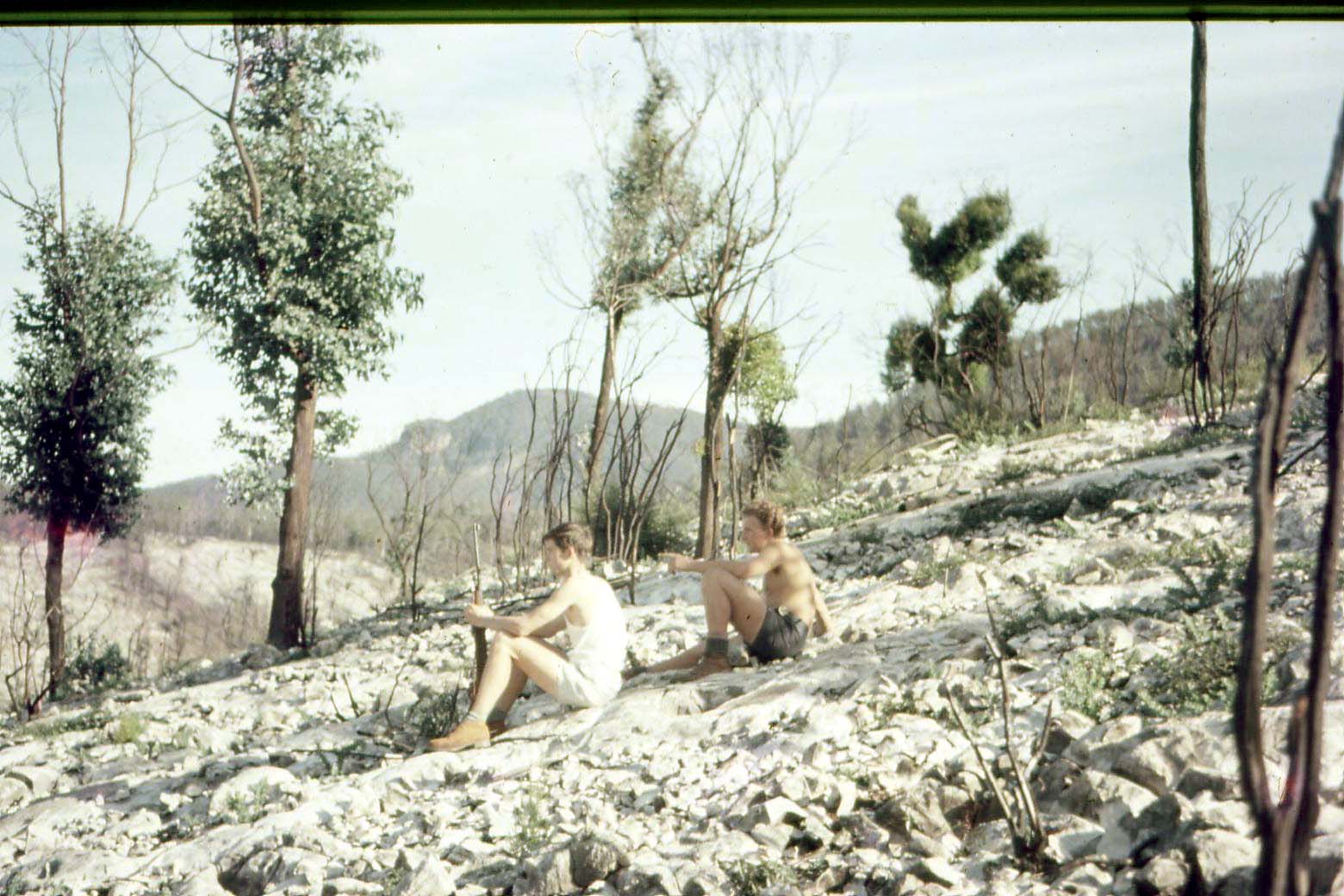 1968 A major
bushfire goes through Bendethera, burning down the second homestead, but making
it easier to find caves. Photo at left by John Redpath shows John Riggs and
Russell Ross.
1968 A major
bushfire goes through Bendethera, burning down the second homestead, but making
it easier to find caves. Photo at left by John Redpath shows John Riggs and
Russell Ross.
Click on the photo to enlarge it.
Easter 1968 Members of ISS carry out much work done on "upper Efflux".
July 1968 Members of ISS extend the track to Efflux (BD2). This makes it easier to carry in heavier things like pit props.
Aug 1968 Members of ISS fired several shots in the Efflux(BD2). Holes drilled using hand star drill.
Oct 1968 Members of ISS fire several shots fired in Efflux (BD2). Project halted due to failure of ignition coil In 240V DC generator.
Jan 1969 Bruce Robinson moves into Bendethera
Easter 1969 Members of ISS tag Main Cave (BD1) and Water Cave (BD4). Echidna Cave (BD55) found and descended, also BD50 - BD54 incl. 50 people visit Main Cave (BD1), at the time, probably a record.
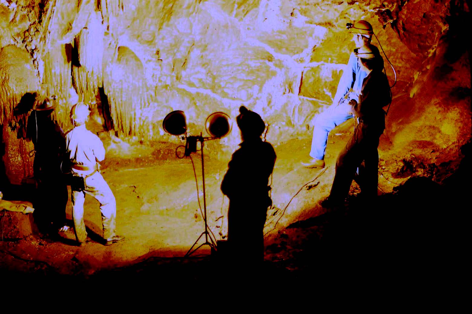 25 Apr 1969 Members
of ISS fire several shots fired in Efflux (BD2). 2 tons of rock removed. Main
Cave (BD1) lit up with 4 x 500W photo flood lights for first time by ISS as
shown at right. Photograph by John Redpath. Click on the photograph to enlarge
it.
25 Apr 1969 Members
of ISS fire several shots fired in Efflux (BD2). 2 tons of rock removed. Main
Cave (BD1) lit up with 4 x 500W photo flood lights for first time by ISS as
shown at right. Photograph by John Redpath. Click on the photograph to enlarge
it.
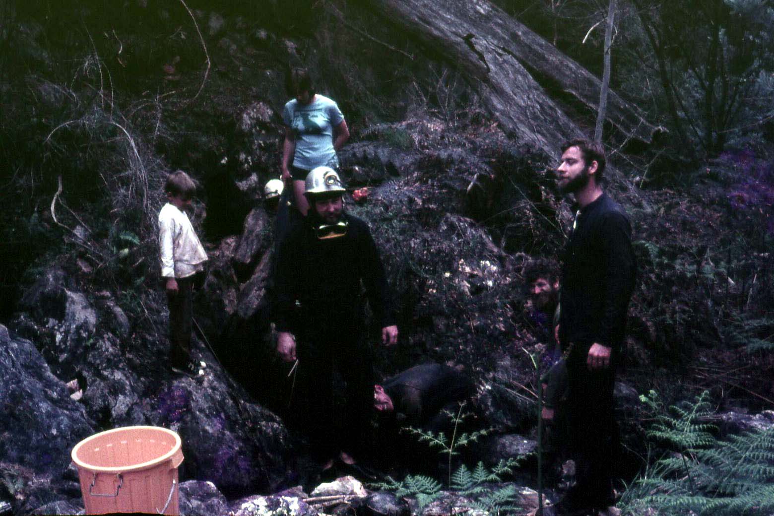
Jun 1969 Members of ISS fire several shots fired in Efflux (BD2). Water Cave (BD4) was dived by members of The South Pacific Diving Group" with backup from SSS. They got to a max depth of 50' before the water became hopelessly muddied. It was still muddy the next day. Members of ISS and SSS visit Echidna Cave (BD55).
Dec 1969 ISS had a big push to get the generator going - not much luck.
1970 Intensive logging of Wandella-Dampier State Forest
 13 Feb 1970 Members
of ISS remove a number of large boulders removed from in front of Efflux
(BD2)by blasting.
13 Feb 1970 Members
of ISS remove a number of large boulders removed from in front of Efflux
(BD2)by blasting.
20 Feb 1970 Members of ISS carry out more work on Efflux. Access gained to a small chamber.
27 Feb 1970 Under difficult conditions, (wet & many trees down) members of ISS remove 2.5 tons of rock removed from Efflux (BD2). Cortex tried (successfully) to break up rocks.
Apr 1970 Members of ISS carry out more work done on Efflux (BD2) - 2 shots fired.
Jun 1970 Members of ISS get the generator going reliably for the first time.
Jul 1970 Members of ISS carry out more work on Efflux (BD2). Vehicle access to Efflux improved making the transportation of timbering easier. Total distance excavated = 30 ft - 10 ft cutting, 20 ft tunnel. 3 shots fired.
Nov 1970 Members of CSS find Figtree Cave (BD14), and "Wet Cave" (Probably the efflux below Gin Cave - BD36 or BD37). Wet Cave surveyed.
Dec 1970 Under difficult and wet conditions, Members of ISS push the Efflux (BD2) further. Three shots fired.
Jan 1972 Bermagui Speleological Association (BSA) formed, some trips run to Bendethera, no specific achievements recorded
Apr 1972 Members of ISS tag Windlass Pit tagged (BD3). BD13 tagged. Several unsuccessful shots fired in Efflux (gelignite too old). Generator retrieved from Bendethera.
1973 Further logging in the Upper Deua catchment begins. Some areas
harvested were included in the Deua Wilderness nomination. May 1973 Members of ISS tag East Pot (BD29), BD30, BD31. Figtree Cave (BD14)
tagged. Jun 1973 Members of ISS tag Gin Cave (BD35), Wet Cave (BD36), Wet Cave
Efflux (BD37) BD38- BD40. August 1974 BSA visit Bendethera and explore Windlass Pit (BD3) to a depth
of 210 ft. Also entered a cave above BD2.They called this cave "KB
Cave". This cave is presently tagged BD-A1. Nov 1974 BSA entered Main Cave (BD1) and surveyed "KB Cave". They
reach a depth of 17.7 M Jan 1975 BSA visit Windlass Pit (BD3) with the intention of surveying it. They
are washed out on the Saturday, so they visit Water Cave (BD4) instead. They
note that BD7 is a dry entrance to BD6?? Windlass Pit (BD3) was surveyed on the
Sunday by Vassey, Warrild and Moore. Apr 1975 Bermagui Cavers locate Wet Cave (BD36), Wet Cave Efflux ( BD37),
BD39, Pipe Cave (BD23) and Figtree Cave (BD14). Aug 1975 Bermagui Cavers survey Water Cave (BD4) and Snake Cave (BD9) 1976 A small party including members of the Landrover Owners Club visit
Bendethera. 1977 Forestry Commission comes to agreement with NPWS to incorporate all of
Diamond Creek catchment in the proposed Deua National Park. 1978 As dedication of Deua National Park draws near, Forestry Commission
advises NPWS that it has withdrawn its agreement to revoke Diamond Creek from
the Dampier State Forest. Logging reaches its highest yearly cut in this area. May 1978 Capital Territory Caving Group (CTCG) visit Bendethera, Main Cave
(BD1) entered, BD13 found, Figtree Cave (BD14) found, BD31 found, Water Cave
(BD4), BD5 and BD6 found. 1979 Bendethera bought by NPWS for incorporation into Deua National Park.
Deua National Park dedicated. Further logging in Wandella-Dampier State Forest
suspended subsequent to an Environmental Impact Statement. Logging in other
areas increased to make up the shortfall. 1980 CTCG visit Bendethera and descend Windlass Pit. (BD3) 1981 Max Perkins, Richard Willson & Co re-discover Pipe Cave (BD23),
BD25, Jim's Cave (BD28) and BD31. Sept 1982 Macquarie Uni Caving Group (MUCG) Visit Bendethera and the
following caves located: Windlass Pit (BD3), BD5, BD6, BD13, BD38, BD39 + other
unnumbered caves on the Krawarree Saddle, two of which were surveyed. BD23 -
BD31 also found, Pipe Cave (BD23) surveyed. 1983 Environmental Impact Statement on Wandella -Dampier State Forest
produced. Forestry Commission reveals its intention to log 93 360 cubic metres
net from Wandella-Dampier State Forest up to 1989. Georges Creek and Diamond
Creek also to be logged at a future date. May 1983 Bushwalking members of SUSS enter Main Cave (BD1) and find the
lower parts of the cave submerged, forming a 10M wide lake. Oct 1984 MSS visit Bendethera and visit Efflux (BD2) and Main Cave (BD1) May 1985 Hills Speleos visit Main Cave BD1. Nov 1985 Hills Speleos find "a horizontal system with possibly 60M
passage and good decoration" above Main Cave (BD1). - Which cave is this-
possibly BD11. 1986 NPWS recommends against further logging in Upper Deua and planned
logging of Diamond and Georges Creeks, arguing for inclusion of these areas in
the Deua National Park. May 1986 Hills Speleos map a "tagless cave" (location unknown) -
"a large cave extremely well decorated" and visit Gin Cave (BD35). Sept 1989 Minister for Natural Resources expresses view that Diamond Creek
should be logged. Mt Dromedary removed from logging due to pressure from
Aboriginal community. Selective logging carried out in Georges Creek area. 1992 Logging in Diamond Creek and Upper Deua catchment continues. Oct 1993 SSS locate Wet Cave Efflux (BD37) (efflux below Gin Cave) and
attempt to dive the sump. A tight squeeze, zero visibility and low air prompted
a hasty retreat, but the report was optimistic. It will be noticed that ISS "lost interest" in Bendethera from
1974 to 1994.There were a number of reasons for this. In 1969, Bruce Robinson
moved into Bendethera, and access became more difficult. From 1974 to 1978, ISS
was busy photographing the Gunbarrel Aven in Wyanbene. The first trip to the
Kimberley was run in 1977, and we were quite active in the Kimberly until 1993
- often running trips on consecutive years. From 1985, ISS suffered a decline
in membership, which in conjunction with potential litigation fears, decided us
to put the club on hold in 1987. All these factors told against us visiting Bendethera
for a number of years. May 1994 First re-visit to Bendethera by ISS since the mid 1970's, start of
survey of homestead precinct. Oct 1994 Members of ISS start the survey of Main Cave (BD1). GPS location of
caves started. BD8 tagged. Water Cave (BD4) surveyed, BD5 surveyed, BD7
surveyed. May 1995 Government prevents logging in all NPWS identified wilderness
areas. June 1995 SUSS visit Bendethera and enter Main Cave (BD1) Oct 1995 Snake Cave (BD9) surveyed by ISS. Nov 1995 Government gazettes the upper catchment of Diamond Creek as an
addition to the Deua National Park. Apr 1996 The Terraces (BD10) located and surveyed by ISS. 1998 Logging in Dampier State Forest within the wilderness nominated area
continues. May 1998 Members of ISS survey East Pot (BD29) and BD24. Pipe Cave (BD23),
BD25, Jim's Cave (BD28) and BD31 re-discovered and positioned. Circa 1999 Endeavour located BD18 and several small caves nearby. Visited
the Efflux (BD2) and Main Cave (BD1), from which they removed much rubbish. June 1999 Members of ISS locate and survey Figtree Cave (BD14), BD60 &
BD61 found and positioned Sept 1999 Members of ISS locate and survey the following caves: Wet Cave
(BD36), BD38, BD39, BD41, BD42 and BD44. BD 46 found and tagged. Members of ISS
unsuccessfully search for the cave believed to be located between Bendethera
and Wyanbene cave (Duea Cave). They do, however, find limestone outcrops. ISS
place a visitor's book at the entrance of Main Cave (BD1). 55 people visit the
cave in September. Oct 1999 72 people visit Main Cave Nov 1999 78 people visit Main Cave Dec 1999 75 people visit Main Cave Jan 2000 210 people visit Main Cave Feb 2000 48 people visit Main Cave March 2000 57 people visit Main Cave April 2000 The following caves are found, tagged and surveyed: BD45, BD47,
BD48, BD49. 168 people visit Main Cave May 2000 42 people visit Main Cave June 2000 53 people visit Main Cave July 2000 22 people visit Main Cave August 2000 19 people visit Main Cave Sept 2000 39 people visit Main Cave Oct 2000 Members of ISS enter BD6 as far as the sump. 70 people visit Main Cave Nov 2000 35 people visit Main Cave Dec 2000 88 people visit Main Cave Jan 2001 185 people visit Main Cave Feb 2001 53 people visit Main Cave Mar 2001 18 people visit Main Cave April 2001 27 people visit Main Cave May 2001 2 people visit Main Cave June 2001 12 people visit Main Cave July 2001 7 people visit Main Cave Aug 2001 8 people visit Main Cave Sept 2001 4 people visit Main Cave Oct 2001 24 people visit Main Cave Nov 2001 20 people visit Main Cave to 17-11-2001 2002 Easter Sat and Sun - 96 April 2002 - 104 May 2002 - 24 June 2002 -56 July 2002 - 108 August 2002 - 19 September to date -13 HISTORICAL REFERENCES Josephine Flood The Moth Hunters, Australian Institute
of Aboriginal Studies, Griffin Press, Canberra 1980 Michael Organ Illawarra and South Coast Aborigines 1770
- 1850, Aboriginal Education Unit, Wollongong University 1990 W.S. Leigh Annual Report of the Department of Mines,1890,
1891, 1892, 1893,1894,1895 Macadoo Martin When Grandma was a Little Girl 1983 Moruya & District Historical Society Then and Now
Moruya & District Historical Society Genies Journal,
Vol 2 No 2 June 1992 Illawarra Speleo Society Bendethera trip reports 1960-1999
see below Sturgiss James Henry The Man From Misty Mountains
1986 Trickett, O. 'Reports on the Limestone Caves for 1899,
1900,1903' Annual Report of the Department of Mines Wallis, G.R. "Report on Bendithera Caves", NSW
Geological Survey Report 1964 "The Shoalhaven" Newspaper 14th June 1930 Colong Foundation for Wilderness NSW Wilderness Red
Index Moruya Examiner 27 Dec 1886, 3 Apr 1889, 18 Apr 1890, 23 May 1890, 6 Jan 1891, 12 June, 1891, 26 June 1891, 25 Jan 1895. TRIP REPORTS where possible the trip leader is mentioned then the club and that club's
newsletter Anderson, Neil, CSS The Very Latest April -June 1968 Biliger, K. "Bendethera" Oolite BMSS Vol 9 No1 June 1977 Bonwick, J. and Ellis, R, "Bendithera" Stop Press SSS, May
1965 pp5-9 Bradley Chris, NUCC 20-25 September 1994 Capital Territory Caving Group "Bendethera Caves" Newsletter 16/5/1978 Chatterton, P. And Philbey, A. "Bendethra" SUSS Bull vol 23
no 2 p45/46 CSS The Very Latest Vol 3 no 9 Ellis, Ross "Bendethera Caves", Stop Press, SSS March 1965
PP 3-5 Franks, Chris Bermagui Caver Vol. 2, No. 2 August 1974 23-24 August
1974 Kates, Graeme, Newsletter Hills Speleo Club Ltd Vol 1 no 3, November
1985, pp 13/14 Hills Speleo Club Ltd Newsletter Vol 1 no 2 Aug 1985 p 3 Hills Speleo Club Ltd Newsletter Vol 2 no 2 Aug 1986 p 12 Illawarra Speleological Society Newsletter Vol 2 no 2 August 1979 Illawarra Speleological Society Newsletter 1994 - 2000 Nichterlein, Dorothy Bermagui Caver, Vol.2 No.4 November 1974, Nichterlein, Dorothy Bermagui Caver, Vol 3 No.2 August September and
October 1975 NUCC, "Bendethera" Ed no 3 1988 p 5 Layton, Carol, "Bendethera" SUSS Bull vol 35 no 2 oct-dec
1995 pp 40/41 Palmer, K. "Annual Bendethera Pilgrimage", Speleograffitti
NUCC, V8 no 1 Feb 1971 Perkins, Max, "Bendethera Trip Report" Quaver MUCC no 4
September 1982 pp 13-16 Richards, Paul, Bendethera Caves Newsletter MSS no 30 1984 Robinson, L et al Bendethera Caves Journal of SSS 1975 vol 19 no 7 pp
170-171 Shiell, Peter, "Bendethera" Stop Press SSS vol 13 no 6 June
1969 pp 89-94 Shiell, Peter, "Bendethera" Stop Press SSS vol 13 no 7 July
1969 pp 117-122 Small, Bruce, "Bendethera" Newsletter Endeavour Speoleo
Assn No 5 August 1975 p 10 Stewart, Bruce, "Cave Diving Trips from Bendethera", Journal of
SSS, 1995 Vol 39 no 6 p 125 Taylor, John, Bermagui Caver, Vol. 2 No. 6 March April and May 1975 Other References ASF, Speleo Handbook Pp 129-130 Suggested Cave classifications for Bendethera karst
2002 From Gilleson Caves A classification system is that used by the National Parks and Wildlife
Service of New South Wales Australia (Worhoys et al. 1989): Group 1 Closed caves Those caves in which access is not permitted because of danger from
instability or foul air or awaiting classification Those caves which are the best representatives of particular attributes of
geology, geomorphology, biology or archaeology. The management aim will be to
preserve such caves in their natural state so that reference sets of caves and
cave life are available in perpetuity. Access will be strictly limited by
scientific research permit to experienced cavers. Each permit will indicate the
nature and value of the research and its likely impacts on the cave. Party size
and experience of users will be specified and impacts should be monitored. Group 3 Limited access caves These Caves have such a quality in their physical or biological attributes
that they warrant special protection, or have a high level of difficulty that
limits cave exploration to very experienced cavers. The principal management
aims are to preserve their high quality and/or maintain a high safety standard.
Gating is desirable where possible, standards of party size and experience will
be strictly maintained and detailed speleological research is to be encouraged. In this group are caves where the physical or biological attributes do not
warrant special protection and the degree of difficulty is suitable for cavers
and novices with some training. The principal management aims are to preserve
the cave's natural
features and provide recreational opportunities for cavers where this does not
conflict with its natural values. Gating is usually desirable where possible,
party size may be limited and each party must have an experienced or accredited
leader. Group 5 Adventure caves These are "walk in caves' with little or no inherent value other than
their morphology, suitable for exploration by inexperienced but properly
equipped groups such as organized youth groups, tourist groups led by
experienced guides, or novice speleologists. Group 5a These are caves as for 5 but require ladders or SRT equipment to assist
access. Group 6 Public access caves These include caves in open areas that have been developed as public
inspection caves or are suitable for that use, and require no special equipment
or clothing unless specified by the ranger. Public access would usually be
either with a ranger or as a self-guided tour. Unclassified Caves (UC) These caves are not yet classified because they have not been
"re-found" and surveyed and/or their significance is not yet known/or
been determined 
Group 2 Scientific reference caves
Group 4 Speleological access Caves
|
NUM |
CAVE NAME |
CLASSIF-ICATION |
REASON FOR CLASSIFICATION |
|
BD- 1 |
BENDETHERA MAIN |
6 |
well known and destroyed |
|
BD- 2 |
EFFLUX |
1 |
dangerous and unstable |
|
BD- 3 |
WINDLASS CAVE |
3 |
70m pit require SRT |
|
BD- 4 |
TRICKETT'S WATER CAVE |
2 |
hydrology/scientific |
|
BD- 5 |
UNNAMED |
4 |
|
|
BD- 6 |
UNNAMED |
2 |
protection of helictites passed the sump |
|
BD- 7 |
UNNAMED |
4 |
|
|
BD- 8 |
SMALL UNNAMED CAVE |
5 |
|
|
BD- 9 |
SNAKE CAVE |
3 |
formations and bat colony at end |
|
BD-10 |
The Terraces |
5 |
|
|
BD-11 |
BAT CAVE |
UC |
|
|
BD-12 |
TINEE TINY FOSSIL CAVE |
5A |
small pits SRT |
|
BD-13 |
UNNAMED |
5 |
|
|
BD-14 |
FIGTREE |
5 |
hard to locate |
|
BD-15 |
UNNAMED CAVE |
uc |
|
|
BD-16 |
UNNAMED CAVE |
uc |
|
|
BD-17 |
SMALL UNNAMED CAVE |
uc |
|
|
BD-18 |
SMALL UNNAMED CAVE |
uc |
|
|
BD-19 |
SMALL UNNAMED CAVE |
uc |
|
|
BD-20 |
SMALL UNNAMED CAVE |
uc |
|
|
BD-21 |
SMALL UNNAMED CAVE |
uc |
|
|
BD-22 |
SMALL UNNAMED CAVE |
uc |
|
|
BD-23 |
PIPE CAVE |
3 |
SRT required |
|
BD-24 |
|
3 |
7M POT |
|
BD-25 |
|
UC |
|
|
BD-26 |
|
3 |
8M POT |
|
BD-27 |
|
UC |
7m pot |
|
BD-28 |
JIM'S CAVE |
3 |
7M POT |
|
BD-29 |
EAST POT |
3 |
20M+ |
|
BD-30 |
KRAWARREE SADDLE |
3 |
|
|
BD-31 |
|
5 |
|
|
BD-32 |
UNEXPLORED HOLE |
UC |
|
|
BD-33 |
UNEXPLORED HOLE |
UC |
|
|
BD-34 |
UNEXPLORED HOLE |
UC |
|
|
BD-35 |
GIN CAVE |
4/UC |
|
|
BD-36 |
WET CAVE |
3 |
wet and muddy/hydrological study |
|
BD-37 |
WET CAVE EFFLUX |
4 |
|
|
BD-38 |
SMALL POT |
5 |
|
|
BD-39 |
UNNAMED |
5A |
|
|
BD-40 |
|
UC |
|
|
BD-41 |
|
5 |
|
|
BD-42 |
SMALL UNNAMED POT |
4 |
|
|
BD-43 |
|
UC |
|
|
BD-44 |
Bent Tree Pot |
5 |
small pot |
|
BD-45 |
|
5 |
|
|
BD-46 |
|
5 |
|
|
BD-47 |
|
5A |
|
|
BD-48 |
|
5 |
|
|
BD-49 |
|
5 |
|
|
BD-50 |
|
UC |
|
|
BD-51 |
|
UC |
|
|
BD-52 |
|
UC |
|
|
BD-53 |
|
UC |
|
|
BD-54 |
|
UC |
|
|
BD-55 |
ECHIDNA CAVE |
UC |
13M DEEP |
|
BD-56 |
possibly KB cave |
UC |
|
|
BD60 |
Paul's Cave |
3 |
SRT deep pot |
|
BD61 |
|
3 |
small pot |
|
BD62 |
|
UC |
LEADS INTO BD6 EFFLUX |
|
BD63 |
|
UC |
|
|
BD64 |
|
5 |
|
|
BD65 |
|
5 |
|
|
BD66 |
|
5 |
|
|
BD67 |
|
5 |
|
|
BD68 |
|
5 |
|
|
BD69 |
|
5 |
|
|
BD70 |
|
5 |
|